Route Editor

| Guide | ♦ | 13 Triplogs | 0 Topics |
details | drive | permit | forecast | 🔥 route |
stats |
photos | triplogs | topics | location |
| 35 | 13 | 0 |
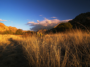
Annual wildflowers, perennial deer by PrestonSands   At the far west end of Chiricahua National Monument is the Bonita Creek Trail, which takes hikers through grassy meadows and creekside woodlands near the mouth of Bonita Canyon. This short and easy trail connects with the Silver Spur Meadow Trail at Faraway Ranch on its eastern end, providing the opportunity for a longer hike. This description begins at the Bonita Creek Picnic Area, which is the western trailhead. At the far west end of Chiricahua National Monument is the Bonita Creek Trail, which takes hikers through grassy meadows and creekside woodlands near the mouth of Bonita Canyon. This short and easy trail connects with the Silver Spur Meadow Trail at Faraway Ranch on its eastern end, providing the opportunity for a longer hike. This description begins at the Bonita Creek Picnic Area, which is the western trailhead.The area that this hike traverses is noted for its wildlife. If you hike this trail during the early morning or late afternoon, you will likely encounter Bonita Creek's resident whitetail deer herd. On every trip I have made to the Monument, I have seen them here.
After about a half-mile or so, the Bonita Creek Trail reaches its end at the Faraway Picnic Area parking lot. On the return trip, consider going straight at the "T" intersection. This western fork of the "T" heads down canyon along the creek for a short distance before wrapping around to the south, where it comes to an end back at the Bonita Creek Picnic Area. Have fun. Hopefully, you'll meet the local deer. Check out the Official Route and Triplogs. Leave No Trace and +Add a Triplog after your hike to support this local community. | ||||||||||||||||||||||||||||||||||||||||||||||||||||||||||||||||||||||||||||||||||||||||||||||||||||||||||||||||||||||||||||||||||||||||||||||||||||||||||||||||||||||||||||||||||||||||||||||||||||||||||||