Route Editor

| Guide | ♦ | 3 Triplogs | 0 Topics |
details | drive | permit | forecast | route |
stats |
photos | triplogs | topics | location |
| 68 | 3 | 0 |
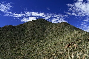
Picture Perfect by fricknaley  Peak 3263 is a perfect desert peak in the northern part of Saguaro West National Park, sitting a few miles north of Wasson Peak. A broad pyramid offers superb views of the desert for those interested in a fun little bushwhack to its summit. Unless you are out wandering in the desert, you'd probably never know it was there. Peak 3263 is a perfect desert peak in the northern part of Saguaro West National Park, sitting a few miles north of Wasson Peak. A broad pyramid offers superb views of the desert for those interested in a fun little bushwhack to its summit. Unless you are out wandering in the desert, you'd probably never know it was there.From the popular trailhead off Picture Rocks road, cross the street into the broad wash that heads out into the desert. I've talked about this before on the Cactus Canyon and Brittlebush routes, so you can also refer to those. The trail that takes off from the parking lot is the Ringtail. It skirts around the western base of Picture Rocks, through the lovely desert. In about 0.4 miles, you come to a signed intersection for the Mule Deer trail, breaking off to the right. Take this short connector for 0.3 easy miles to the intersection for the Ironwood Forest Trail. Take a left onto the Ironwood Forest trail and head out to Picture Rocks Wash. The Ironwood trail is a very nice, rambling desert trail with fantastic views of the park and the Tortolita and Catalina mountains. Wasson is always present, and towards the end, you can start to see the picturesque Peak 3263 to the right, with its smooth north ridge (your route of attack). After roughly 1.2 miles or nearing 2 miles total, you will dead-end in Picture Rocks Wash.
Check out the Official Route and Triplogs. Leave No Trace and +Add a Triplog after your hike to support this local community. | ||||||||||||||||||||||||||||||||||||||||||||||||||||||||||||||||||||||||||||||||||