username
X
password
register
for free!
help
 This is likely a great time to hike this trail!  Check out "Preferred" months below, keep in mind this is an estimate.
   🔥

Samaniego Ridge Trail #7, AZ

Guide 32 Triplogs  0 Topics
  3.6 of 5  
Fav
Wish
0
details
drive
permit
forecast
🔥
route  
stats
photos
triplogs
topics
location
367 32 0
Statistics
tap row or icons for details
Difficulty 1.5 of 5
Distance One Way 6.8 miles
Trailhead Elevation 7,213 feet
Elevation Gain -2,143 feet
Accumulated Gain 922 feet
Kokopelli Seeds 9.87
 Backpack Yes
Photos Viewed All MineFollowing
Will recalculate on button tap!
10  2025-09-21 Pivo
17  2023-06-17
Samaniego Ridge Pines
Jim
68  2023-06-17
Mount Lemmon Trail #5
Mike_W
12  2017-10-20
Samaniego Peak
markthurman53
16  2017-05-08
Charouleau Gap Samaniego Ridge
markthurman53
24  2016-09-09
Catalina Mts Samaniego Ridge
markthurman53
24  2014-05-28
Samaniego Peak
Mountain_Rat
11  2012-10-29
Canada del Oro Trail #4
nicolelee
Page 1,  2
Author
author avatar Guides 16,832
Routes 17,471
Photos 24
Trips 1 map ( 6 miles )
Age Male Gender
Location HAZ, TrailDEX
Associated Areas
list map done
Tucson Region
Historical Weather
Trailhead Forecast
Radar Map
Expand Map
Preferred May, Sep, Aug, Oct → 7 AM
Seasons   Spring to Autumn
Sun  6:31am - 5:45pm
Official Route & 3 Rts
 
7 Alternative
 
Historic Fire Perimetersacres
🔥 2020 Bighorn Fire119.5k
🔥 2003 Aspen Fire87.7 mi*
🔥 View (All) - over Official Route 🔥
*perimeter length in miles


remove free decal offer
Where in the world did the ridge go?
by HAZ_Hikebot

 Likely In-Season!
Expand Map
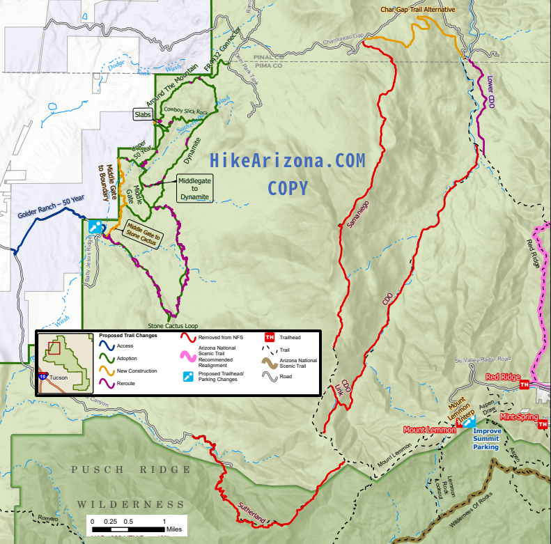
Bushwhackers beware, the National Forest manages by abandonment.
June 2023 - Decommissioning 5.28-miles
Notes: Long distance northside trail offering expansive views, connecting CDO and Charouleau Gap road but unsustainable in places and difficult to follow
Proposed: Change to Class 2. Lower portion: complete reroutes just south of Charouleau Gap to improve usability. Middle portion: remove 5.28 mi from NFS. Upper portion: extend trail to Sutherland Trailhead, what is currently named CDO


    Check out the Official Route and Triplogs.
    Leave No Trace and +Add a Triplog after your hike to support this local community.

    One-Way Notice
    This hike is listed as One-Way.

    When hiking several trails on a single "hike", log it with a generic name that describes the hike. Then link the trails traveled, check out the example.
    WARNING! Hiking and outdoor related sports can be dangerous. Be responsible and prepare for the trip. Study the area you are entering and plan accordingly. Dress for the current and unexpected weather changes. Take plenty of water. Never go alone. Make an itinerary with your plan(s), route(s), destination(s) and expected return time. Give your itinerary to trusted family and/or friends.

     Permit $$
    Coronado Permits

    Four specific day-use areas require a Coronado Recreational Pass or a National Pass/America the Beautiful Pass.
    1) Sabino Canyon - located on the Santa Catalina Ranger District (520)749-8700
    2) Madera Canyon - located on the Nogales Ranger District (520)281-2296
    3) Cave Creek - located on the Douglas Ranger District (520)364-3468
    4) Mt. Lemmon at 11 day-use sites.

    2025 Catalina State Park
    Per vehicle (1 person): $10.00
    Per vehicle (2-4 people): $20.00
    Individual/bicycle: $5.00

    2022 Sabino Canyon Tram is $15 extra. [ website ]

    Coronado Forest
    MVUMs are rarely necessary to review unless mentioned in the description or directions
    Coronado Motor Vehicle Use Maps (MVUMs)


     Directions
    or
     Road
    Paved - Car Okay

    To hike
    helpcorrectionissue

    end of page marker