username
X
password
register
for free!
help
   🔥

Sabino Canyon Trail #23, AZ

Guide 92 Triplogs  1 Topic
  3.7 of 5  
Fav
Wish
4
details
drive
permit
forecast
🔥
route  
stats
photos
triplogs
topic
location
513 92 1
Statistics
tap row or icons for details
Difficulty 2 of 5
Route Finding 1 of 5
Distance One Way 2.65 miles
Trailhead Elevation 3,350 feet
Elevation Gain 498 feet
Accumulated Gain 859 feet
Avg Time One Way 1.5 hours
Kokopelli Seeds 5.51
 Backpack Yes & Connecting
 Dogs not allowed
feature photo
Photos Viewed All MineFollowing
Will recalculate on button tap!
22  2025-04-19
Santa Catalina Mountains - AZT #11
DarthStiller
4  2025-03-31
Sabino - Bear Canyon Loop
fricknaley
15  2025-01-20
Sabino Canyon to Catalina State Park
ddgrunning
8  2024-12-29
Sabino - Bear Canyon Loop
fricknaley
19  2024-12-07
Sabino Canyon to Catalina State Park
fricknaley
26  2024-04-03
Catalinas Loop
LindaAnn
13  2024-04-03
Cathedral Rock - Hutch's Pool Traverse
Mountain_Rat
3  2023-01-28
Sabino - Bear Canyon Loop
fricknaley
Page 1,  2,  3,  4,  5,  6
Author
author avatar Guides 34
Routes 249
Photos 2,197
Trips 592 map ( 4,584 miles )
Age 38 Male Gender
Location Portland, OR
Associated Areas
list map done
Sabino Canyon Recreation Area
Tucson Region
Historical Weather
Trailhead Forecast
Radar Map
Expand Map
Preferred Mar, Nov, Feb, Jan → 7 AM
Seasons   Autumn to Spring
Sun  6:01am - 6:43pm
Official Route & 1 Rt
 
26 Alternative
 
Historic Fire Perimetersacres
🔥 2020 Bighorn Fire119.5k
🔥 2003 Aspen Fire87.7 mi*
🔥 View (All) - over Official Route 🔥
*perimeter length in miles


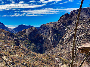
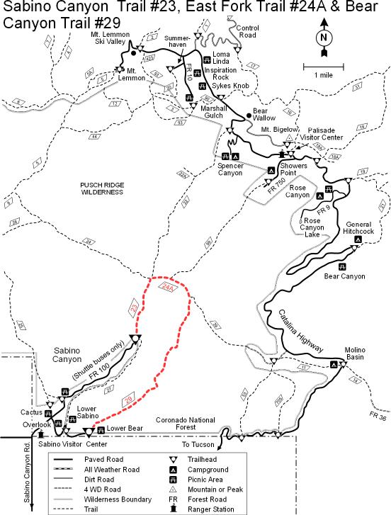
Get Above the crowds!
by keepmoving

Overview
Sabino Canyon #23 is an excellent choice for hikers wishing to escape the tram-infested Upper Sabino Canyon Road in search of more solitude. Upon arriving at the Northern end of Sabino Canyon #23, hikers will be treated with a variety of trails that lead into the heart of the Pusch Ridge Wilderness.


Hike
From the end of Upper Sabino Canyon Road, head North from the pavement to the signpost that marks the beginning of Sabino Canyon #23. Follow the trail as it begins to work its way up a series of switchbacks. As the trail gains elevation, views of Sabino Canyon quickly open up as you leave the tourists and the trams behind. Half a mile later, the trail arrives at the top of the switchbacks at a signed junction with the Phone Line Trail. Sabino Canyon #23 turns left at the junction and begins to curve along the hillside, eventually passing an old sign that warns hikers not to shortcut the switchbacks you just finished climbing. Immediately after this sign, the trail passes a well-worn spur trail that leads along a short, narrow ridge to a great viewpoint high above the canyon floor.
remove free decal offer
Continuing past the side trail, Sabino Canyon #23 contours along the hillside as it approaches Sabino Basin. For the next mile or so, Sabino Creek is hidden from view far below at the bottom of the canyon. However, it is not long before the views begin to open up once more and Sabino Creek is soon visible again as it drains from Sabino Basin. As Sabino Basin comes into view, look for another spur trail off to the West that follows a short path to an overlook that affords great views into Sabino Creek and Sabino Basin. Beyond the side trail, Sabino Canyon #23 begins to rapidly lose elevation as it approaches its Northern Terminus with West Fork #24 and East Fork #24A.

2009-08-27 keepmoving
  • S_map.JPG
    guide related
  • Sabino Canyon Recreation Area Map
    area related
    Sabino Canyon Recreation Area Map
Coronado FS Details
These three trails offer access to the dramatic landscape of the Santa Catalina Front Range, famous for its deep canyons and soaring ridges. When traveled as a loop, they form a long but rewarding day-trip that offers memorable views and access to the riparian environments they shelter. A trip along either trail or around the entire loop will treat you to good views of the high ridges and peaks of the Front Range and, at sunset, of the city of Tucson with its lights framed by the black silhouette of surrounding mountains.

Since both Bear Canyon and Sabino Canyon trails are accessible from the extremely popular Sabino Canyon Recreation Area, both are used heavily. Sabino Canyon Trail begins at the end of the recreation area shuttle bus route and contours along the canyon’s eastern slope a good distance above the canyon floor. A number of paths branch off the trail along this stretch and lead down to the streambed.

Bear Canyon Trail leads upstream from the Lower Bear Picnic Area at the end of the Bear Canyon shuttle route. The trail crosses the stream several times in its first two miles and provides spectacular views of both Sabino and Bear canyons as it climbs to Bear Saddle. There it intersects the East Fork #24A and the Sycamore Reservoir #39 trails. The East Fork Trail follows Sabino Creek 2.1 miles to the junction with Sabino Canyon Trail. From this point it is 2.5 miles back to the end of the road where hikers can catch a shuttle bus ride (for a fee) or walk back to your car to complete a 13.4 mile loop. Since horses are not permitted on the shuttle road, equestrians must use the Phone Line Trail #27 (4.5 miles) to complete a loop.

Attractions: Spectacular canyon, lush desert, long distance views, backcountry access, more difficult loop possibilities, access to trail #24A a segment of the Arizona Trail.

Check out the Official Route and Triplogs.
Leave No Trace and +Add a Triplog after your hike to support this local community.

One-Way Notice
This hike is listed as One-Way.

When hiking several trails on a single "hike", log it with a generic name that describes the hike. Then link the trails traveled, check out the example.
WARNING! Hiking and outdoor related sports can be dangerous. Be responsible and prepare for the trip. Study the area you are entering and plan accordingly. Dress for the current and unexpected weather changes. Take plenty of water. Never go alone. Make an itinerary with your plan(s), route(s), destination(s) and expected return time. Give your itinerary to trusted family and/or friends.

 Permit $$
Visit overview & permits.
2024 - FAQ
$8 per vehicle per day
$10 per vehicle per week
$40 per vehicle per year (valid for one year from the date of purchase)

There are four specific day-use areas that require a Coronado Recreational Pass or a National Pass/America the Beautiful Pass.
1) Sabino Canyon - located on the Santa Catalina Ranger District (520)749-8700
2) Madera Canyon - located on the Nogales Ranger District (520)281-2296
3) Cave Creek - located on the Douglas Ranger District (520)364-3468
4) Mt. Lemmon at 11 day-use sites.

2022 Catalina State Park
Per vehicle (1-4 Adults): $7.00
Individual/bicycle: $3.00

2022 Sabino Canyon Tram is $15 extra. [ website ]

Coronado Forest
MVUMs are rarely necessary to review unless mentioned in the description or directions
Coronado Motor Vehicle Use Maps (MVUMs)


 Directions
or
 Road
Paved - Car Okay

To hike
From Tanque Verde Road in Tucson turn north on Sabino Canyon Road and follow it 4 miles to the Sabino Canyon Recreation Area Visitor Center. From the Visitor Center, between the hours of 9 a.m. and 4 p.m., hikers can take the shuttle bus (for a fee) to Bear Canyon and Sabino Canyon trailheads. If you prefer, or if the shuttle bus is not running, you can hike to the trailheads along the shuttle bus route. Equestrians must stay on the designated horse trails.
 90+° 8am - 6pm kills
helpcorrectionissue

end of page marker