 Route Editor

| Guide | ♦ | 209 Triplogs | 3 Topics |
details | drive | permit | forecast | 🔥 route |
stats |
photos | triplogs | topics | location |
| 666 | 209 | 3 |
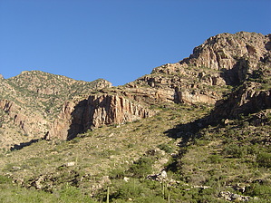
The flagship of the Front Range by Jeffshadows  Background BackgroundPima Canyon is one of the gems of the front range of the Santa Catalina mountains. The canyon has been occupied by humans since long before a European ever set foot in the New World, as evidenced by the mortar holes ground into the bedrock in the canyon which has been dated to around 750AD. The holes were left by the Hohokam, and the canyon is named for one of their presumed descendant groups, the Akimel O'Odham (formerly the Pima). A good portion of Pima Canyon is riparian and the initial course the Pima Canyon Trail (#62) follows is not strenuous, making it a very popular day-hiking destination. The trailhead and easement developed to allow access to Pima Canyon is named in honor of Iris O. Dewhirst, a former member of the Governor's Advisory Board on the Arizona Environment and a consummate lobbyist for outdoor recreation. Near the beginning of the trail stands a plaque dedicated to Tom Bingham, a local conservationist and a man who was instrumental in securing access to Pima Canyon for future generations in wake of the development that had begun to overtake the area. Bingham fell to his death while climbing alone in Pima in 1992. Signs in the area orient visitors to the fact that the first 3/4-mile of the trail is an access corridor flanked by private property.
The parking area at the trailhead has a water fountain and refuse bin, and is gated. The gate is locked at "dusk" and then opened again at "dawn", which seems to mean roughly 10 PM and 6 AM most of the year. Hike Pima offers several different hike opportunities. In addition to linking to numerous side routes to attractions that tower above the canyon, the Pima Canyon Trail meets the Finger Rock Trail at its terminus, allowing for through-hiking opportunities. The trail itself also offers several hike options, as detailed below: ( figures appear incorrect... )
Notes: The length listed is one-way as measured by GPS, not map; the times are based on an average formed from times posted in triplogs. The hike from the trailhead to the first dam is by far the most popular. After departing the trailhead, the first three-quarters of a mile follows the bottom of a rocky wash that is flanked by ranch wire fences and no trespassing signs. Beyond these fences lie private property. The track turns north, climbs a small foothill, and encounters a horse barrier that marks the original trailhead location and the official entrance to the National Forest and Wilderness. Dogs and bicycles are forbidden beyond this gate. Immediately after passing through the boundary gate, the track again turns north and steeply scales a short foothill to achieve the general elevation it will follow for its course along the ridgeline until reaching the Pima stream course. This section of trail is riddled with social trails and vistas and is a popular destination for groups seeking to watch sunsets or the city lights. This is also a good area to see Gila Monsters in the spring months. After continuing along the ridge for almost a mile, the track turns south and descends a series of boulder steps into the first major stream crossing. The track climbs around to the south bank of the stream and takes up a course through the canyon bottom that winds through scrub and catclaw while flanking the stream course. This continues for about a half-mile before the track encounters another, sometimes confusing, wash crossing. Hikers unacquainted with Pima have cut a deep track due south across the stream here; ignore this track and follow the one that heads east through the grass on the bank of the stream. After crossing the stream, the track begins to scale the south wall of the canyon for a bit, then follows along a rocky ridge above the canyon before descending again to meet the stream course and a lovely riparian zone. The track crosses the stream twice, once near an unnamed V6-rated boulder problem, and then approaches an area that is popular for picnics. Large cottonwoods grow here, and there is usually water to be found even in the driest months. Rosewood point looms high above to the south and the Cleaver can be seen on the north canyon rim. After leaving the riparian zone, the track climbs slightly again and reaches the southern bank of the canyon through a series of grassy ruts that are frequently muddy in wet months. Here the track encounters the confluence of the major drainage joining Pima Canyon from the unnamed canyon dropping in from the southern wall. A sidetrack departs due south, here, and can be followed to Rosewood Saddle and Point. The track winds through a stand of tall creosote and past a seat that has been fashioned into the trunk of a large palo verde tree. This grass area is popular with campers. Another route departs into the confluence, here, that climbs into Prominent Point. The track follows the south bank of the canyon for a time, climbing slightly, then dropping again to cross over to the north bank. After passing through a large grouping of ocotillo, the track winds in and out of a drainage flanking the major stream course before beginning to ascend the north bank and the lower northern wall of the canyon. The track ascends a minor ridge and then drops into the stream course and turns sharply south. After climbing a few boulders, the track passes by bedrock with metate holes ground into its surface. A minor spur trail departs due north, here, to the first dam built by the AZ Fish and Game service in the 1960s to help provide water for bighorn sheep and other wildlife in the wilderness area. Make sure to return to the trail after visiting the dam, as a well-worn social trail leaves the dam toward the stream course resulting in an unnecessary bushwhack. After leaving the first dam spur trail, the track takes up a familiar pattern of winding through the canyon bottom around scrub which becomes increasingly grassy. Oak and other chaparral foliage begin to appear and the track winds its way around a large rock outcropping. After rounding the outcrop, the track drops into the canyon, crosses the stream course, and then follows the north wall of the canyon for a short time. Soon thereafter, the track drops back into the canyon and crosses at a point that is surrounded by a lush riparian zone, passing near a small natural waterfall. After the falls, the track begins to climb the south wall of the canyon and winds through the scrub for another half-mile gaining some elevation as it approaches the second dam. This section of trail offers awesome views into the canyon bottom, below, and to the left, which is populated with small riparian zones and pools of water when in wetter months. Views back to the west of Tucson also begin to open up, dominated by Wasson Peak and Baboquevari in the distance. After turning north and descending steeply into the canyon bottom, the second dam appears above series of natural pools in the bedrock lining the stream course. The track crosses over to the north wall of the canyon after the second dam and begins to climb much more steeply than before. The course of the track becomes sandy and rocky with knee-high walls for a time before approaching a canopy of juniper and mixed oak-scrub, the beginning of which is heralded by a large, lone pinyon pine. The track continues to ascend with a steeper grade as it winds through this juniper forest and climbs, almost vertically at times. The course of the track straightens out and continues along the south wall of the canyon for a time before turning back into the stream course and approaching Pima Spring. The spring is on the east wall of the canyon and is dry most of the year. Water can be found nearby in the stream course to the south of the spring. Near the spring are several leveled and cleared areas with accompanying rock fire rings suitable for comfortable wilderness camping. After leaving the spring, the track climbs the north wall and ascends steeply, leaving the juniper canopy and becoming exposed. It climbs the north wall for a time and encounters a track leading off to the north which appears to be heading to a saddle, above. This route leads to the saddle and the summit of Buster Mountain and provides a rare view of the backside of Finger Rock. The track of the Pima Canyon Trail turns sharply south at this junction and drops back toward the canopy of trees in the canyon bottom. The ascent becomes difficult as the track climbs into the saddle beneath a canopy of juniper and pinyon. This new strenuous grade continues for roughly a half-mile as the track approaches Pima Saddle. Larger pine begins to appear and a small metal sign points out the small spur trail that leads two-tenths of a mile to the north and the saddle. The views from the saddle are amazing, including a view of the backside of Mount Kimball and a nice, unobstructed view of Mount Lemmon. After leaving the saddle, the trail winds to the south, and the climbing starts up, again. The track becomes less distinct as it winds around a large rock outcropping and over loose rock and tree roots. The grade is familiarly steep but now the footing becomes precarious. The views here are unmatched anywhere in the Catalinas, which makes the climb a little easier. After roughly three-quarters of a mile, the track widens and begins to level, slightly. The track becomes sandy and begins to wind east through a forest of pinyon and gneiss boulders that will remind those familiar with the Catalinas of Windy Point. After taking up an almost straight course, the track appears to be climbing into Mount Kimball, which is the case. Soon, the pinyons begin to give way to a pine forest and the track approaches a large white pine whose roots are growing beneath the track and creating a natural speed bump in the course. The Pima track turns southeast here, but another track appears to continue to the north, this is the unofficial Mount Kimball spur trail and this junction is unsigned and often missed. The craggy summit of Mount Kimball is three-tenths of a mile of easy climbing along the spur trail after this intersection. The track continues southeast from the intersection with the Kimball spur trail and begins to descend along a wide course through the pine. The pine canopy soon becomes more sparse and then disappears, entirely. The track continues to descend, now through a series of red sandy gullies flanked by pinyon. As the gullies disappear, the track becomes wider and rockier before approaching the signed junction with the Finger Rock Trail after a half-mile descent from the junction with the Kimball spur. Gate Policy: If a gate is closed upon arrival, leave it closed after you go through. If it is open, leave it open. Leaving a closed gate open may put cattle in danger. Closing an open gate may cut them off from water. Please be respectful, leave gates as found. The exception is signage on the gate directing you otherwise. Coronado FS Details Though the stream in Pima Canyon is dry for most of the year, it supports an excellent example of a desert riparian habitat located conveniently close to the Tucson metropolitan area. Unfortunately, that accessibility has resulted in significant overuse of this beautiful and fragile area, especially during the winter, its season of highest use. From the trailhead, located among suburban ranchos, the trail ascends a V-shaped notch carved along the south face of Pusch Ridge. Views down the canyon get better as you climb, encompassing the city of Tucson as well as distant mountains and valleys. The riparian area on the floor of the canyon provides excellent birdwatching for a wide variety of resident and migratory species that make use of this most productive of all desert habitat types. Other desert creatures you may encounter in this area include javelina and jackrabbits, but the real viewing prize of Pima Canyon and the entire Pusch Ridge area are the desert bighorn sheep that maintain a surefooted existence here among rocky crags and rugged canyons. Beyond Pima Spring, the trail becomes steeper and harder to follow as it continues to climb to the upper slopes of Mt. Kimball. Incentives for persevering here are good views of Window Rock and Cathedral Rock. Trail #62 ends at its junction with the Finger Rock Trail #42. Attractions: Riparian forest, canyon hike, craggy peaks, watchable wildlife and Tucson views! Check out the Official Route and Triplogs. Note This is a difficult hike. Arrive fit and prepared or this could get ugly. Leave No Trace and +Add a Triplog after your hike to support this local community. One-Way Notice This hike is listed as One-Way. When hiking several trails on a single "hike", log it with a generic name that describes the hike. Then link the trails traveled, check out the example. | |||||||||||||||||||||||||||||||||||||||||||||||||||||||||||||||||||||||||||||||||||||||||||||||||||||||||||||||||||||||||||||||||||||||||||||||||||||||||||||||||||||||||||||||||||||||||||||||||||||||||||||||||||||||||||||||||||||||||||||||||||||||||||||||||


