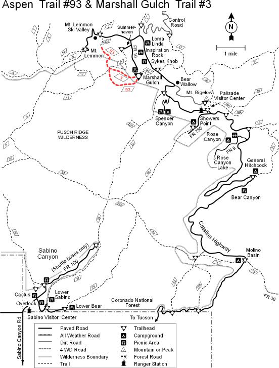
The loop formed by these two trails is one of the most heavily used upper elevation routes into the Pusch Ridge Wilderness. This moderate hike leads through an area of diverse habitats that include excellent examples of Canadian Zone riparian areas and ponderosa pine forests. If you're a bit of an amateur naturalist, you might want to bring a guide to Arizona's trees as well. You'll see quite a few different species along this trail which changes aspect and life zones as it loops around a false summit of Marshall Peak. You'll find aspens here, of course, but you'll also pass by Douglas-fir and white fir, Gambel and silverleaf oak, madrone and more.
Notable sights along this view-rich trail include the bare granite walls of the uppermost reaches of Sabino Canyon, through which the first half mile or so of the Aspen Trail passes. Along this part of the route the pathway literally sparkles with flakes of mica and quartz. After taking in the wide angle overlooks at Lunch Ledge and Marshall Saddle, both of which include overlooks of the Wilderness of Rock area, towering Lemmon Rock, and Romero Pass, take the Marshall Gulch Trail back to your starting point. It leads down a cool, shady canyon which is usually well stocked with wildflowers and pleasant little pools.
Attractions: Great views, scenic canyon, cool mountain setting, fall colors and easy access!
WARNING! Hiking and outdoor related sports can be dangerous. Be responsible and prepare for the trip. Study the area you are entering and plan accordingly. Dress for the current and unexpected weather changes. Take plenty of water. Never go alone. Make an itinerary with your plan(s), route(s), destination(s) and expected return time. Give your itinerary to trusted family and/or friends.
Four specific day-use areas require a Coronado Recreational Pass or a National Pass/America the Beautiful Pass.
1) Sabino Canyon - located on the Santa Catalina Ranger District (520)749-8700
2) Madera Canyon - located on the Nogales Ranger District (520)281-2296
3) Cave Creek - located on the Douglas Ranger District (520)364-3468
4) Mt. Lemmon at 11 day-use sites.
2025Catalina State Park
Per vehicle (1 person): $10.00
Per vehicle (2-4 people): $20.00
Individual/bicycle: $5.00
Coronado Forest MVUMs are rarely necessary to review unless mentioned in the description or directions Coronado Motor Vehicle Use Maps (MVUMs)
Directions
Road
Paved - Car Okay
To Marshall Gulch Trailhead From Tucson, at the intersection of Tanque Verde and Catalina Highway, go North on the Catalina Highway just over 30 miles. You will pass the small community of Summerhaven. The road ends at Marshall Gulch picnic area. You really can't miss it, it's all the way to the end. The parking is limited so come early!
Take the Catalina Highway off Tanque Verde Road in Tucson. Drive 4.2 miles to the Forest boundary and continue 26 miles through Summerhaven to the Marshall Gulch Picnic Area. All roads are paved, but chains or 4-wheel drive may be required in winter because of snow. The trailhead is at the end of the road. You'll have to walk the last couple of hundred yards in winter when the road into the picnic area is gated closed.
 Route Editor

 The loop formed by these two trails is one of the most heavily used upper elevation routes into the Pusch Ridge Wilderness. This moderate hike leads through an area of diverse habitats that include excellent examples of Canadian Zone riparian areas and ponderosa pine forests. If you're a bit of an amateur naturalist, you might want to bring a guide to Arizona's trees as well. You'll see quite a few different species along this trail which changes aspect and life zones as it loops around a false summit of Marshall Peak. You'll find aspens here, of course, but you'll also pass by Douglas-fir and white fir, Gambel and silverleaf oak, madrone and more.


