Route Editor

| Guide | ♦ | 176 Triplogs | 0 Topics |
details | drive | permit | forecast | route |
stats |
photos | triplogs | topics | location |
| 503 | 176 | 0 |
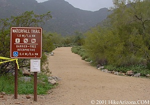
Desert Gusher by joebartels   Here's a small jewel very close to the valley. The trail starts ridiculously wide and turns into nothing. Folks of all ages will be seen heading out on this trail. Seemed odd as I saw two families pushing strollers. Midway into the trail where it narrows I passed several strollers stashed alongside the trail. There's nothing wrong with that I just got a good chuckle. Here's a small jewel very close to the valley. The trail starts ridiculously wide and turns into nothing. Folks of all ages will be seen heading out on this trail. Seemed odd as I saw two families pushing strollers. Midway into the trail where it narrows I passed several strollers stashed alongside the trail. There's nothing wrong with that I just got a good chuckle.It's best to tackle this easy to moderate trail after a good rain. If it poured the night before head on out. A rare early morning shower would be best. The trail skirts the creek then turns into an easy scramble near the waterfall. Choose your steps wisely or you'll get a little wet. Personally, I'd put on the Tevas and slosh right through it. Be careful as the wet rocks are slippery. After a mild to average rain, some small pools get about knee-deep. It's not necessary to get wet, but you may not get as close to the falls. The falls curve around a bend to the right. The falls are multi-tiered. Sometimes it's only possible to see the top section if you risk a shallow wade. - 2/98 joe
Nevertheless, it was a good trip. Like the lower Four Peaks and Superstition Wilderness areas, rain brings the desert to life. In addition, I checked out the Mesquite Trail. In the past year, I've gained more of an interest in mapping. The White Tank Mountains viewed from valley mountain peaks appear to be a single north/south ridge. In reality, it's several parallel east/west ridges including countless tiny peaks. Not perfect ridges and canyons but still an interesting twist on my previous thoughts. Signs all over remind you to stay on the trail. There used to be a connecting trail to the Mesquite Trail. It's history. I chatted with six or seven small groups. Everybody had a previous waterfall story. I always get a kick out of these kind of stories! Note although I prefer a hike after heavy rain, I should forewarn of possible flash flooding Warning Climbing on or near the falls is extremely dangerous, several deaths have resulted in the past
Check out the Official Route and Triplogs. Leave No Trace and +Add a Triplog after your hike to support this local community. | ||||||||||||||||||||||||||||||||||||||||||||||||||||||||||||||||||||||||||||||||||||||||||||||||||||||||||||||||||||||||||||||||||||||||||||||||||||||||||||||||||||||||||||||||||||||||||