 Route Editor

| Guide | ♦ | 155 Triplogs | 0 Topics |
details | drive | permit | forecast | 🔥 route |
stats |
photos | triplogs | topics | location |
| 680 | 155 | 0 |
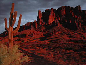
Fossicking On The Trail by AZLOT69  In the broad definition, prospecting is the search for minerals, oil, flora, or fauna, so in one way or another, everyone on the trail is prospecting. The Lost Dutchman State Park has a trail system for nearly all abilities. Named for Jacob Waltz, the fabled Lost Dutchman, even the easiest trails in this park can give you an up-close personal experience with the Superstition Mountains. As you experience these trails, imagine the old prospector who historically would be on his hands and knees inspecting and combing thru the washes, ridgelines, and rock outcroppings looking for the color gold or other minerals. In the broad definition, prospecting is the search for minerals, oil, flora, or fauna, so in one way or another, everyone on the trail is prospecting. The Lost Dutchman State Park has a trail system for nearly all abilities. Named for Jacob Waltz, the fabled Lost Dutchman, even the easiest trails in this park can give you an up-close personal experience with the Superstition Mountains. As you experience these trails, imagine the old prospector who historically would be on his hands and knees inspecting and combing thru the washes, ridgelines, and rock outcroppings looking for the color gold or other minerals.To describe the Prospector trail as short would be a disservice because the only thing it is short on is distance. The trail can be accomplished in either direction and can be used in various ways to create larger loops within the park.
The trail is a moderate climb and gains 317 feet in the next 0.6 miles. Rocky and sometimes loose footing describe the trail as it climbs up compacted scree which has come off the mountain over the centuries. Ahead and to the right are tailings from the Palmer Mine. Equipped with binoculars, you can easily spot some diggings. Equally viewing the towering crags in front of you with bionic eyes, you may spot some wildlife and natural caves. At one-quarter mile, a bench should encourage you to turn around and look how far up you are from the valley. You can see the skyline of downtown Phoenix from here on a clear day, the Goldfield Mountains, the Goldfield Ghost town, South Mountain, and the San Tans to the south. After the switchbacks and just past the second bench at 0.4 miles, an unmarked trail to the right is the trail to the Palmer Mine although it is much easier to access off the Siphon Draw trail. Reaching the highpoint of the trail gives you additional views of Four Peaks to the north. Arriving at the third bench, marks the end of the Prospector trail as the Praying Hands feature looms above. Joining the signed Treasure Loop Trail #56 at this point offers options on your return to the trailhead. Check out the Official Route and Triplogs. Leave No Trace and +Add a Triplog after your hike to support this local community. One-Way Notice This hike is listed as One-Way. When hiking several trails on a single "hike", log it with a generic name that describes the hike. Then link the trails traveled, check out the example. | |||||||||||||||||||||||||||||||||||||||||||||||||||||||||||||||||||||||||||||||||||||||||||||||||||||||||||||||||||||||||||||||||||||||||||||||||||||||||||||||||||||||||||||||||||||||||||||||||||


