 Route Editor

| Guide | ♦ | 324 Triplogs | 1 Topic |
details | drive | no permit | forecast | 🔥 route |
stats |
photos | triplogs | topic | location |
| 2.3k | 324 | 1 |
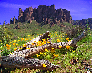
Drifting by AZLOT69  History HistoryOne method miners used to attempt to find gold in the Superstition Mountains was to make a trench across the grain or flow of rock in an attempt to locate a vein of gold underground. Once located, the vein was accessed by drift mining, the method of following the aimless vein of gold in whatever direction it took. It reflects the lifestyle of the namesake for this trail Jacob Waltz, The Lost Dutchman, a drifter who crossed the country on his quest for gold. His drifting ended according to legend in the Superstition Mountains where he located a source of gold and spent the last twenty years of his life living his dream and maintaining the anonymity of this source of gold. Overview Jacob's Trail #58 drifts along the front range of the Superstitions at a right angle to the many trails that lead up to the Superstitions. It is a great moderate introduction to the terrain and condition of the rugged trails making up the Superstition Wilderness. It offers an amazingly diverse display of Sonoran vegetation and awesome views of this intriguing mountain range. The trail is described as one way from north to south starting at the Crosscut Trailhead off First Water Road and ending at the Broadway trailhead. It makes a great key exchange, shuttle hike, or combination with other trails to make a lasso loop or continuing backpack.
The hike starts with an immediate crossing of Weekes Wash. Don't forget to look back to the north as you climb a hill that offers nice views of Little Four Peaks alongside Four Peaks. This area has quite a variety of old-growth that will inspire photographers. At the first unmarked intersection bear left and at the following intersection continue straight. It should be obvious which trail appears to be the main trail. Look left at about 0.68 miles and observe mine tailings and what remains of some old diggings. At one mile the mature vegetation ends as you approach the Lost Dutchman State Park. Several fires in past years have devastated the area. The trail takes a turn toward the mountain which in morning light looks dark and ominous ahead. The hoodoos are prominent, silhouetted by morning light. Soon a major trail intersection with the Treasure Loop appears. Continue straight to another intersection with the Treasure Loop. Continuing straight brings you to the first of two benches. From the bench observe the Goldfield Mountains to the west. The Goldfield Ghost Town is toward the southwest as is Bulldog Mountain and the Bulldog Mine. To the south, the front range of the Superstitions appears barren and flat although on a slope, void of any large plants. The fields of brittlebush ahead are so thick they appear to be planted as to be harvested. The fire's devastation however has led to renewal and is very apparent as you serpentine thru the first of countless washes each bigger than the next which are chocked with new growth. Look carefully as you cross these washes, each seems to sport a different variety of plants and offer countless side trips many of which are used for geocaching. At just over two miles the Flatiron comes into view about the time you meet the Prospectors Trail #57. Continue straight past this trail and the next unmarked trail which turns right. The next intersection is Siphon Draw #53. No doubt you will feel the draw to turn left towards the mountain but Jacob's Trail #58 continues straight. South of the Siphon Draw Trail I would not recommend mountain bikes as the trail gets considerably rougher. Fields of rocks are camouflaged by the brittlebush. There is a great spot to take a break at about 2.6 miles. A huge flat-top boulder is a nice spot for a snack and to enjoy views of the flatiron soon to be out of sight. There are homes off to the west and occasional sounds of civilization. Perhaps you will be lucky and hear the train whistle or the mine tour whistle at the Goldfield Ghost Town. The return echos out of Siphon Draw are awesome. On the day I scouted this hike some emergency response sirens started a chorus of animal sounds from the residential area. Dogs howling, horses, mules, and donkeys responding in kind. It was quite a symphony. As things settled down you could hear one lone carpenter pounding nails on a new build. Just short of three miles after crossing a large wash the mature vegetation suddenly resumes with several ancient ironwood trees followed by great stands of prickly pear. Soon a grove of cholla with views ahead of a forest of saguaro. The trail now approaches a boulder field with some being the size of small houses. The trail gets thick with adult acacia and palo verde. The Silly Mountain complex lies ahead in the distance and looks small from this vantage point. At 4.5 miles look for Teepee cave up on the mountainside. An interesting bushwhack side trip marked by a huge two-boulder cairn. Staghorn cactus are abundant at 4.75 miles and just past this point, the flatiron appears again with some unique views not often seen in photographs. You now find the trail swings southeast heading for Dinosaur Mountain in the distance. At 5.44 miles you arrive at a Y intersection simply marked trail, bear right. The next half mile will test your balance skills as well as the footbed of your shoes. The trail is made up entirely of loose rocks. There are several trails to choose from as people search for an easier way. The trails all converge so there is no wrong way. Stay with the most used. A walking stick certainly helps to negotiate this section. The trail improves at the intersection with the Lost Goldmine Trail #60. Bear right to finish Jacob's Trail #58 which ends in one-half mile at the Broadway trailhead. Special Note Hike Arizona thanks HAZ Legend Fritzski for providing the first summary that filled this page from 2001-04-27 until 2008-11-08.
Check out the Official Route and Triplogs. Leave No Trace and +Add a Triplog after your hike to support this local community. One-Way Notice This hike is listed as One-Way. When hiking several trails on a single "hike", log it with a generic name that describes the hike. Then link the trails traveled, check out the example. | |||||||||||||||||||||||||||||||||||||||||||||||||||||||||||||||||||||||||||||||||||||||||||||||||||||||||||||||||||||||||||||||||||||||||||||||||||||||||||||||||||||||||||||||||||||||||||||||||||||||||


