Route Editor

| Guide | ♦ | 6 Triplogs | 0 Topics |
details | drive | no permit | forecast | route |
stats |
photos | triplogs | topics | location |
| 62 | 6 | 0 |
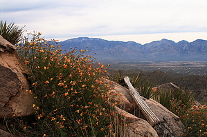
superior display of saguaros by fricknaley  2013 Route Modification Access is now from the Ritz. 2013 Route Modification Access is now from the Ritz.Ridge Crest Peak is the distinctive pyramid-shaped peak in the Tortolita Mountains, the high point of the south wall of Wild Burro Canyon. You can see it from all over Tucson, and I have been staring at it for years, wondering if, when, and how I'd get up. Take off from the common Wild Burro Trailhead and go through the hikers' gate. Drop down into the wash. This is Wild Burro wash. There is a signed, maintained trail, or you can take the wash. It doesn't matter. Your objective is the interior of the Tortolitas via Wild Burro Canyon. The wash passes through a yet uncompleted golf resort. Nothing special with this part of the hike... just make hay to the canyon. There is some lovely desert vegetation along the way.
Head towards the nearby gully and cross over it. Then head due south straight up the ridge. This is a somewhat brutally steep climb. The footing is pretty good. However, avoid shindaggers and cholla. From the takeoff, it's only about 1/4 mile to the summit. If you can hit the west slope that rides up east to the summit, you are home-free. Scramble as necessary, and you can generally see where to go. When you hit the ridge, you may pick up a trail that apparently comes up from the other side up the ridge (from Canyon Pass). If so, take it up 5 minutes to the summit. Otherwise, keep on grinding. The views from the top are sweet. The Catalinas are laid out like never before, a who's who of Pusch Ridge. The Tortolita interior is everywhere. Great looks at Picacho, Santa Ritas, and the Tucson mountains abound. Baboquivari is in the background too. Be careful on the way down and angle back towards the Alamo Springs trail... please study a topo map and consider a GPS for this desert peak. It's worth it. Gate Policy: If a gate is closed upon arrival, leave it closed after you go through. If it is open, leave it open. Leaving a closed gate open may put cattle in danger. Closing an open gate may cut them off from water. Please be respectful, leave gates as found. The exception is signage on the gate directing you otherwise. Check out the Official Route and Triplogs. Leave No Trace and +Add a Triplog after your hike to support this local community. | |||||||||||||||||||||||||||||||||||||||||||||||||||||||||||||||||||||||||||||||