Route Editor

| Guide | ♦ | 7 Triplogs | 0 Topics |
details | drive | permit | forecast | route |
stats |
photos | triplogs | topics | location |
| 57 | 7 | 0 |
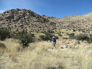
Mingle with Nature by Jeffshadows  Overview OverviewHidden pasture is a picturesque bowl of grass hidden in the hills, for lack of a better description. It's a natural amphitheater surrounded by and passing through scenic rock formations. Hidden Pasture itself is marked on maps of the area, and the route can be discerned by looking at the stream path leaving it and arriving at Ash Creek, which is also marked on maps. The route takes a hiker into the Little Rincon mountains for a quick tour to land less visited. Hike There is no official trail, but cairns can often be seen in the canyon. The route begins at a large staging area about 3-tenths of a mile beyond the end of McKenzie Ranch, just inside of Coronado National Forest. The pullout is right off the side of the road and should be easy to distinguish. Equestrians and their trailers frequent the spot to stage for rides. Just beyond this pullout to the East is Ash Creek. The route crosses Ash Creek at a point often marked by cairns directly in from the pullout. A beaten path leads as far as the creek.
Beyond the granite buttress, the route rejoins the stream-course and snakes its way uphill, bypassing small rock formations, a few large trees, and deep cutouts in the canyon floor. One has to use a little imagination to find the best way through some of the scree and minor obstacles the stream throws your way, but the views make up for it all. The route follows the path worn into the stream's bedrock and is easy to follow, easier if water is present. The stream zig-zags for a while and arrives at another rock face where the canyon has cut through the wall. The cutout is too small to pass, but the wall can again be overcome by climbing out to the north and returning back down to the stream. Soon after returning to the stream-course, one will see North Star Peak to the southeast. This peak is the highest point in the Little Rincons. A series of boulders marks the confluence of a draw-dropping steeply down from this peak and intersecting with the stream, the route follows. This point is approximately 2.3 miles in. Intrepid explorers can follow this draw and scramble up to North Star peak, if so inclined. It takes a little imagination to pick a route between the boulders and get back on course with the stream, now headed due east. After winding north and then back northeast, the stream bed meets another small granite wall, one which is easily scrambled head-on. From here, the route can be made up as you go, head toward the open grassland straight ahead. The canyon opens widely into a grass bowl surrounded by ridges, and North Star Peak to the South. The route has now covered roughly three miles and arrived at Hidden Pasture. Enjoy the splendor and return the way you came.
Check out the Official Route and Triplogs. Leave No Trace and +Add a Triplog after your hike to support this local community. | |||||||||||||||||||||||||||||||||||||||||||||||||||||||||||||||||||||||||||||||||||||||||||||||