 Route Editor

| Guide | ♦ | 41 Triplogs | 2 Topics |
details | drive | permit | forecast | route |
stats |
photos | triplogs | topics | location |
| 514 | 41 | 2 |
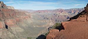
Tonto Rollercoaster by HAZ_Hikebot  Overview OverviewThe dynamic interplay of soft and hard layers of stone creates an open benchland at the rim of the Inner Gorge called the Tonto Platform. Easily visible from several South Rim overlooks, the greenish Tonto rocks have eroded into an obvious exception to the striking vertical cliffs that characterize most of Grand Canyon. The Tonto Trail follows this natural transcanyon route for 95 rough, unmaintained miles, from Red Canyon on the east to Garnet Canyon on the west. All of this makes the Tonto Trail unique among Grand Canyon pathways. Most descend from the rim towards the Colorado River, but the Tonto Trail offers passage by foot up and down the canyon, parallel to the river's course. Because of its length, most hikers approach the Tonto Trail not as a single unit but rather as a series of installments, breaking the route down into four or five sections defined by rim to river trails and the natural lay of the land. The trek along the Tonto Trail between the Grandview and Kaibab Trails offers experienced canyon walkers a representative introduction to the pleasures, as well as the problems associated with travel along this important inner canyon feature. Hike The Tonto Trail is like a contour line on your map. The trail descends into the side canyons only when there is no other option, preferring to traverse into the drainages at a consistent elevation. It is often indirect, but Tonto Trail hikers would be well advised to have faith and follow the trail - it almost always represents the most efficient way across the landscape. One quickly discovers that a trail, any sort of trail, makes for much easier forward progress. Shortcuts will not save time. The trail is not signed. The Tonto Trail leaves the bed of Cottonwood Creek near the top of the Tapeats Formation, contours around the west arm, and heads west toward Grapevine. Entering Grapevine from the east involves a short section of narrow, eroding trail with significant exposure. The views down into the lower reaches of Grapevine are wonderful but watch your step. By far, Grapevine is the largest and most complex side canyon between the Grandview and the South Kaibab Trails. Looking across the drainage's mouth from the Tonto Trail, the distance seems short, but plan on at least 2-3 hours of steady hiking to cross. The small unnamed drainages between Grapevine and Boulder and Boulder and Lone Tree will slow progress, and a little confusion on the west side of Lone Tree is typical. Still, generally speaking, the route between Grapevine and Cremation Creek is straightforward.
Notes The dry, hostile nature of the Tonto Platform belies the fact that prehistoric populations have utilized this desert landscape for thousands of years. A trained eye can detect archaeological sites in many of the side canyons. These sites testify to the creative intelligence that sustained these people over many generations living out their lives within the harsh, unforgiving world of the inner Grand Canyon. If you should find or visit such sites, please leave everything in place, exactly as you found it. Water Sources The Tonto Trail is notorious for its lack of reliable water sources, and this section is no exception. Do not expect the river to be a water source in this area; river access via side canyons in this segment ranges from extremely difficult to impossible. Heavy water loads are the norm, and dry camps almost inevitable. Check with the Backcountry Information Center for the latest water reports before embarking, know where your next drink is coming from, and have enough water to get you there. The combination of open, sunny country, lack of shade, many dry miles, and only a single reliable water source makes this hike dangerous during hot weather. The issue of water in your pack vs. distance to the next reliable spring is one to always keep in mind along the Tonto Trail. Cottonwood Creek (BG9) Cool weather: Southern spring is usually reliable. Northern Spring and O'Neill Spring are unreliable at best. Hot weather: May be dry. Grapevine Creek (BH9) Cool weather: Water in the east arm at the Tonto Trail crossing and from the spring on the east side of the drainage. Hot weather: Water ordinarily available in the east arm above or below Tonto Platform level (but sometimes dry at the Tonto Trail) and usually a small trickle from the spring on the east side of the drainage. Further downcanyon water abounds. Boulder Creek (BH9) Cool weather: Dry at the Tonto Trail crossing. Small amounts are occasionally found above the Tonto Platform level. Water may also be found downstream for about 20 minutes. Hot weather: Dry. Lone Tree Creek (BJ9) Cool weather: Small amounts at or below Tonto Trail crossing (the most reliable water source is a half-hour walk below the Tonto crossing near a lone cottonwood tree). The spring originates in the Muav. Hot weather: Dry. Cremation Creek (BJ9) Dry all year. Occasional potholes in the Tapeats (down the west arm of the drainage). Emergency Water Sources Page Spring and Hance Creek (east of Horseshoe Mesa), Burro Spring and Pipe Creek (west of the Tip-off), and Bright Angel Campground (at the bottom of the Kaibab Trail) are reliable. Any of these sources would represent a significant detour and will only be utilized by the truly desperate. Campsites "At-large" camping is allowed between Cottonwood and Cremation Creeks (see above for use area codes). Hikers should follow Leave No Trace guidelines when selecting campsites to minimize group impact. Campsites are often located where the Tonto Trail crosses the drainages and often on the Tonto Platform between the side canyons. Some regularly used campsites, especially near water, support a resident population of rodents, ravens, and other canyon residents; take steps to protect your food and gear. Segments to Consider:
Check out the Official Route and Triplogs. Leave No Trace and +Add a Triplog after your hike to support this local community. One-Way Notice This hike is listed as One-Way. When hiking several trails on a single "hike", log it with a generic name that describes the hike. Then link the trails traveled, check out the example. | ||||||||||||||||||||||||||||||||||||||||||||||||||||||||||||||||||||||||||||||||||||||||||||||||||||||||||||||||||||||||||||||||||||||||||||||||||||||||||||||||||||||||||||||||||||||||||||||||||||||||||||||||||||||||||||||||||||||||||


