username
X
password
register
for free!
help
  

Tonto Trail: New Hance Trail to Grandview Tr, AZ

Guide 46 Triplogs  1 Topic
  4.3 of 5  
Fav
Wish
2
details
drive
permit
forecast
route  
stats
photos
triplogs
topic
location
740 46 1
Statistics
tap row or icons for details
Difficulty 3 of 5
Route Finding 1 of 5
Distance One Way 9.1 miles
Trailhead Elevation 2,610 feet
Elevation Gain 1,370 feet
Avg Time One Way 4.5 hours
Kokopelli Seeds 13.67
 Backpack Yes & Connecting
 Dogs not allowed
feature photo
Photos Viewed All MineFollowing
Will recalculate on button tap!
10  2024-05-21
Escalante Route: Tanner to Grandview
ckoss_
20  2022-03-19
New Hance to Grandview
ddgrunning
11  2021-10-02
Grandview - Tonto - New Hance
jacobemerick
15  2020-02-27
Tanner to Grandview GC
derpsquad
15  2020-02-15
New Cottonview
chumley
25  2020-02-15
New Cottonview
BiFrost
20  2016-04-09
Tonto-New Hance-Grandview
The_Eagle
20  2016-04-09 Tortoise_Hiker
Page 1,  2,  3,  4
Author
author avatar Guides 16,843
Routes 17,472
Photos 24
Trips 1 map ( 6 miles )
Age 28 Male Gender
Location HAZ, TrailDEX
Associated Areas
list map done
Northwest Region
Historical Weather
Trailhead Forecast
Radar Map
Expand Map
Preferred Nov, Feb, Mar, Jan → Early
Seasons   Autumn to Spring
Sun  6:02am - 6:51pm
Official Route
 
10 Alternative


remove free decal offer

Guide Needed
Publish Full Detail Guide


Use +Add above to share photos and triplogs


Happy

Trails!


  • Grand Canyon Use Area Boundaries - Dynamic Map


Check out the Official Route and Triplogs.
Leave No Trace and +Add a Triplog after your hike to support this local community.

One-Way Notice
This hike is listed as One-Way.

When hiking several trails on a single "hike", log it with a generic name that describes the hike. Then link the trails traveled, check out the example.
WARNING! Hiking and outdoor related sports can be dangerous. Be responsible and prepare for the trip. Study the area you are entering and plan accordingly. Dress for the current and unexpected weather changes. Take plenty of water. Never go alone. Make an itinerary with your plan(s), route(s), destination(s) and expected return time. Give your itinerary to trusted family and/or friends.

 Permit $$
no fees or permits reported

if incorrect tell us about it

Grand Canyon National Park
Details for each are occasionaly below numerous alerts
Entrance Fee
Overnight/Backpacking Permits
Grand Canyon Use Areas Map
Rim-to-Rim and Extended Day Hike/Run


 Directions
or
 Road
Connector trail - Not Applicable

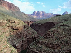
To New Hance Trailhead
Access to this trailhead is from the Grand Canyon Village. This trailhead is unsigned, but not too difficult too find. It lies 13.6 miles east of the Arizona Highway 64 & Village Loop Road intersection. At this point, which is at the bottom of the grade between Buggein Picnic Area and Moran Point, there is a small pull out area which has several “No Parking” signs along its length. There is no parking at the trailhead so one must drop off the majority of your party and all of your backpacks before taking the vehicle to one of the two parking areas and walking back. The first is Moran Point which is 1.2 miles further east. However, I’d recommend parking alongside the fire road which is 0.6 miles west of the trailhead. This dirt road heads south and is gated several hundred yards down, but one can pull off and park anywhere along it.

From PHX (I-10 & AZ-51) 240 mi - about 3 hours 53 mins
From TUC (Jct 1-10 & Grant) 345 mi - about 5 hours 24 mins
From FLG (Jct I-17 & I-40) 93.5 mi - about 1 hour 46 mins
 90+° 8am - 6pm kills
helpcorrectionissue

end of page marker