Route Editor

| Guide | ♦ | 9 Triplogs | 0 Topics |
details | drive | no permit | forecast | map |
stats |
photos | triplogs | topics | location |
| 23 | 9 | 0 |
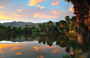
Hot Water Springs by PaleoRob  The Tucson area of southern Arizona has some of the most diverse and easily accessible trails in the Sonoran desert. Some are wild backcountry hikes into the Santa Catalinas, Rincons, or other mountain ranges that dot the basin. Others are local hikes that are popular and don't require serious wilderness experience but are still fun and interesting. One of these later sorts of hikes is located at Agua Caliente Regional Park. The Tucson area of southern Arizona has some of the most diverse and easily accessible trails in the Sonoran desert. Some are wild backcountry hikes into the Santa Catalinas, Rincons, or other mountain ranges that dot the basin. Others are local hikes that are popular and don't require serious wilderness experience but are still fun and interesting. One of these later sorts of hikes is located at Agua Caliente Regional Park.Agua Caliente means Hot Water in Spanish, and the park gets its name from a spring located at the southeastern portion of the park that is indeed warm. The water that comes out of this spring originates high in the Catalina Mountains. It seeps down into the earth and flows downhill, being heated by the earth. As it nears the bottom of the mountain it encounters a fault block that forces the water up to its face, where it bubbles out, still warm. This spring was important throughout human history in the Tucson basin. The Hohokam used this spring as a water source; the large Whiptail village is located on private land less than 1/4 of a mile away from the spring. Later, during pioneer days, ranchers diverted its flow into several ponds to water cattle. Later entrepreneurs made these hot ponds into a tourist attraction, touting the water's "healing properties." Remnants of all these phases of occupation can be seen still at Agua Caliente Regional Park.
The best place to start the hike is at the beginning and follow the water. From the parking lot, head to a shady grove of trees in the southeast corner of the park on a paved path. Here is where the spring bubbles to the surface. There are also a couple of signs that talk more about the geology and history of the spring and the basin. From here, proceed along the creek on the paved path. Ducks, turtles, and many varieties of fish thrive in the spring-fed creek and the one remaining pond. Especially in winter, the bird population explodes. This part of the park is popular not only with hikers and dog walkers, but also Frisbee players and BBQers, so this isn't a solitary hike. The trail bends north where the creek flows into the pond. There used to be a series of ponds fed by the spring, as recently as 2001, but the lower ponds have been drained to restore the habitat. The large upper pond was left, however, because of its historical significance and as a wildlife habitat. The trail follows the eastern edge of this pond to the historic resort buildings. Most of these are closed to the public. From here you can begin to get away from most of the crowds by heading west-northwest, crossing a creek on a bridge, and leaving the paved path. The trail winds around the two dry lower ponds and is certainly less crowded than the grassy portion of the park. Here you are in Sonoran desert habitat, not manicured public space. This stretch of trail is not attractive at the moment. Despite the great views of the Catalina Mountains between the trees, the former ponds are not attractive as they are slowly recovering to their natural state. The trail is generally flat, however, and well-graded so this is a good section for a trail jog or to take your dog for a walk. Once you complete the loop around the lower ponds, the trail returns you to the grassy section of the park via the same bridge over the creek. Return to your vehicle and grab your BBQ stuff for a fun after-hike meal! Water: Don't drink the water from the creek or spring. There are several water fountains around the grassy area of the park that usually work. Use them instead. Check out the Triplogs. Leave No Trace and +Add a Triplog after your hike to support this local community. | |||||||||||||||||||||||||||||||||||||||||||||||||||||||||||||||||||||||||||||||||||||||||||||