Route Editor

| Guide | ♦ | 83 Triplogs | 3 Topics |
details | drive | no permit | forecast | 🔥 route |
stats |
photos | triplogs | topics | location |
| 1.1k | 83 | 3 |
Canyons are inherently risky. Flash floods occur without notice on sunny days. Technical skills & surrounding topography knowledge required yet does not eliminate risk.
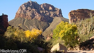
Excellent adventure by joebartels  In 1990 5,800 acres were set aside seven to ten miles south of Superior. The White Canyon Wilderness was formed. Lucky you, lucky me, as this is one awesome canyon. The canyon is mentioned as a possible route for the AZ Trail on their website ( year 2000... never materialized ). I can't imagine why anybody would bypass this canyon while in the area! In 1990 5,800 acres were set aside seven to ten miles south of Superior. The White Canyon Wilderness was formed. Lucky you, lucky me, as this is one awesome canyon. The canyon is mentioned as a possible route for the AZ Trail on their website ( year 2000... never materialized ). I can't imagine why anybody would bypass this canyon while in the area!From the narrow-ended road, the trail is easy to find. Actually, there is no official trail. This is light canyoneering with huge boulders. The going is medium effort. Obstacles are numerous, though easily negotiable. The route is to follow the canyon upstream. Which never really leaves the canyon bottom. Maybe a few feet up the side here and there.
A little over two miles in is a dry waterfall on the right. This would surely be an awesome view during thunderstorm runoff. Just be forewarned; downed willows and swirled sandbanks show the power of flooding in this canyon. Don't be a statistic; stay out if you're unsure. It's about a mile and a half more to the Tonto Forest boundary. Pleasing canyon wall views continue, but the real excitement has been conquered. More brushy sections and less boulder hopping lies ahead. I was pretty amazed when I first drove in to find a trail register out in the middle of nowhere. Then to see that several have passed through this area over the years. It had been a while since the last entry. On the other hand, there were more entries than I would have expected for such a remote area. We got a good chuckle reading the entries. Several noted how beautiful the canyon was, but the repeated gunfire was annoying. I guess we lucked out as we didn't experience the gunfire. Then again, we came at the hottest and most humid time of the year, so there wasn't much company. Other trip note entries included "looking for the BIG Javelina", "played with animals", "to cave, great trip", "clear water pools", "totally stoked", "consistent gunshots added to the wilderness feel", "press on past boulders, worth it!", "save the desert, club a golfer!", "saw javelinas". Along the way, we saw a blue jay, only to be distracted by a cardinal zipping past him. We also saw a snake, a baby turtle dive into one of the pools. Nearly every pool encountered involved a few frogs lunging in. Only one plane flew by in the far distance. Nobody else was in the canyon. No gunfire but passed ma and pa homer on the way out in Walnut Canyon river bottom. They had shovels and were doing something on the side of the river. Hopefully, nobody died. Have fun and be careful. 8/15/00 TRIP (2): White Canyon was in my mind as the best hike of the year. Naturally, I returned. This time Rachelle tagged along. On the first trip, Rasco came along in mid-August. As always, he keeps up with the pace, which continues to amaze me. On this my first hike with Rachelle, she too did a remarkable job. No complaining and kept up with the pace remarkably well. Who knows, maybe I'm getting old. I'm sure the annual Four Peaks Christmas romp will separate the boys from the men. In August, it had rained the previous night. The humidity was unbelievable until the afternoon sun cleared it up. On this outing, in late November, the weather was perfect in the low seventies! We were greeted by a running creek from all the early November rains. I thought, cool; this is gonna be even better with running water. There were several pools and cascades along the way. Unfortunately, the creek was the path last time out. This time we had to bushwhack around the creek. So my question has been answered about the Arizona Trail. Yep, they need to do some serious work here before calling this a trail. We went in two miles. I didn't want to kill Rachelle on her first outing. I've never been one to snack on the trail. Basically, I usually carry a few mountain biking (what I call) sugar packets. If you're tired and burnt, they get you going in a hurry. Well, since Rachelle is so damn fragile, I decided I better bring something more to munch on. Since I'm not into snacking, I did the Joe thing. I brought everything I could think of eating on a trail. ...so the final report... The little peanut butter Ritz crackers were awesome on the trail! Probably why I'm getting FAT! The trail register entries didn't seem to mention so much gunfire this time. Once again, we didn't hear any either. There was one long entry from an agitated man. He wrote...they should pave the trail and make it wheelchair accessible. He said it was so boring and blah blah blah. I'll tell ya what, if this is boring, I wonder what excites this guy! On the way out, we passed two couples that were hiking the two-mile access road, which has beautiful scenery but nothing like on the trail. One couple had just made it to the trail register on our way out. They signed the register and headed back. I thought it seemed funny to hike a road to a trail then turn around. I'm wondering if the upset guy even made it on the trail. Maybe he just hiked the road like these other two couples. Once again, driving out, we were both in disbelief. We made it up the rutted section. How, we don't know. It's pretty rutted in this one section. Again I gunned it. Although we seemed to nearly turn over BOTH ways, there was no damage. I used the Rasco technique and didn't tell Rachelle it was coming. On the previous trip, Rasco asked me are snakes with yellow and black rings poisonous? I was like, I don't know, why? He said, oh, cause there's one in-between your feet. Thanks! Anyhow the real reason for the trip was to play with my new camera. It's official. I suck! I kept getting my aperture and other crap I know nothing about all wrong. At least I'm honest!!! I guess I'll actually have to read that damn manual! Time to start digging in the trash. 2.5MB MP3 Audio - Teva reading trail log Check out the Official Route and Triplogs. Leave No Trace and +Add a Triplog after your canyon trip to support this local community. | ||||||||||||||||||||||||||||||||||||||||||||||||||||||||||||||||||||||||||||||||||||||||||||||||||||||||||||||||||||||||||||||||||||||||||||||||||||||||||||||||||||||||||||||||||||||||||||||||||||||||