username
X
password
register
for free!
help
 This is likely a great time to hike this trail!  Check out "Preferred" months below, keep in mind this is an estimate.
  

Massai Point Nature Trail - Chiricahua NM, AZ

Guide 29 Triplogs  0 Topics
  4 of 5  
Fav
Wish
0
details
drive
permit
forecast
map
stats
photos
triplogs
topics
location
87 29 0
Statistics
tap row or icons for details
Difficulty 0.5 of 5
Route Finding 1 of 5
Distance Loop 0.5 miles
Trailhead Elevation 6,878 feet
Elevation Gain 49 feet
Accumulated Gain 72 feet
Avg Time Round Trip 0.75 hour
Kokopelli Seeds 0.86
 Backpack No
unreported if dogs are allowed
editedit > ops > dogs to adjust
feature photo
Photos Viewed All MineFollowing
52  2025-04-16
Echo Loop Inspiration & Massai Points
CannondaleKid
9  2016-05-29
Echo Canyon Loop - Chiricahua NM
cindyl
11  2016-05-26
Heart of Rocks Loop Trail
cactuscat
51  2014-12-27
Chiricahua Shuttle
outdoor_lover
10  2014-05-30 rwstorm
12  2014-05-27
Chiricahua Shuttle
SkyIslander18
30  2012-11-20
Big Loop - Chiricahua National Monument
SkyIslander18
14  2011-02-20
Big Loop - Chiricahua National Monument
SkyIslander18
Page 1,  2
Author
author avatar Guides 170
Routes 148
Photos 5,914
Trips 2,097 map ( 11,156 miles )
Age 48 Male Gender
Location Tucson, AZ
Associated Areas
list map done
Tucson Region
Historical Weather
Trailhead Forecast
Expand Map
Preferred Oct, Apr, May, Sep → 8 AM
Seasons   ALL
Sun  5:55am - 6:36pm
2 Routes
 
3 Alternative


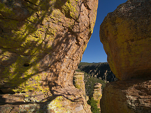
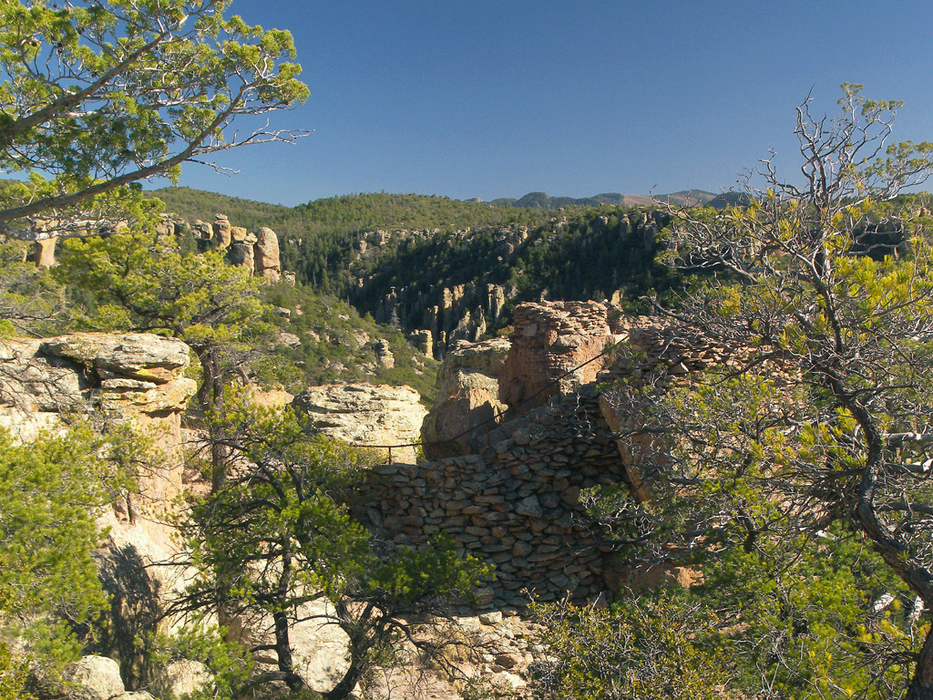
Big Foot's escape route
by PrestonSands

 Likely In-Season!
Overview
The Massai Point Nature Trail is a short, educational loop hike at Chiricahua National Monument, that explains the area's natural history. Interpretive signs along the trail describe the Chiricahua Mountain's violent volcanic past, subsequent geologic events, and the creation of its unusual rock formations. Other signs enlighten visitors to the Monument's biological communities and human history. Although this easy hike is not the Monument's star attraction, it answers the "how and why" of the Chiricahua National Monument.


Hike
Beginning at the north end of the Massai Point parking lot, the Massai Point Nature Trail heads north into the trees. It immediately comes to a signed junction with a short side trail, that heads uphill to an exhibit building at the apex of Massai Point. Follow the trail to the small exhibit building, which affords 360-degree views of southeastern Arizona. Plaques inside the circular structure describe the sky island aspect of the Chiricahua Mountains and show the outline of the Turkey Creek Caldera. At the rear of the exhibit building, a cement walkway leads down the backside of the hill to the beginning of the Massai Point Nature Trail.
remove free decal offer
Now back at its beginning, follow the Massai Point Nature Trail downhill to the west, away from the parking lot. The trail contours along a hillside, where pinyon and cypress trees frame a wonderful view to the west, overlooking the Monument. Further on, the trail passes the junction with the Ed Riggs Trail, and a short spur trail leading back to the parking lot.

The trail now ventures into an area of hoodoos overlooking Rhyolite Canyon. A short side trail climbs to the top of one of the hoodoos, where a viewpoint has been constructed. There are sweeping views to be found at its tiny summit. A large balanced rock rests nearby.

Leaving the hoodoos behind, the Massai Point Nature Trail finishes wrapping around Massai Point, before turning north to return to the Massai Point parking area. A sign marks its arrival at the south end of the parking lot.

2008-04-07 PrestonSands


    Check out the Triplogs.
    Leave No Trace and +Add a Triplog after your hike to support this local community.
    WARNING! Hiking and outdoor related sports can be dangerous. Be responsible and prepare for the trip. Study the area you are entering and plan accordingly. Dress for the current and unexpected weather changes. Take plenty of water. Never go alone. Make an itinerary with your plan(s), route(s), destination(s) and expected return time. Give your itinerary to trusted family and/or friends.

     Permit $$
    NPS

    Coronado Forest
    MVUMs are rarely necessary to review unless mentioned in the description or directions
    Coronado Motor Vehicle Use Maps (MVUMs)

    Chiricahua National Monument
    Chiricahua NM $5 per person / 7 Day Entrance Fee


     Directions
    or
     Road
    Paved - Car Okay

    To hike
    From I-10 exit 340 in Willcox, head south on Highway 186 for about 33.2 miles to Highway 181. Turn left (east) onto Highway 181, and follow it for 3 miles to the Chiricahua National Monument entrance. (see fee above) Follow the road (which later becomes "Scenic Drive") for approximately 7.5 miles beyond the Monument entrance, to its end at the Massai Point parking lot. There are trail signs for "Massai Nature Trail" at the north and south ends of the parking lot.
     90+° 8am - 6pm kills
    helpcorrectionissue

    end of page marker