 Route Editor

| Guide | ♦ | 18 Triplogs | 0 Topics |
details | drive | no permit | forecast | route |
stats |
photos | triplogs | topics | location |
| 128 | 18 | 0 |
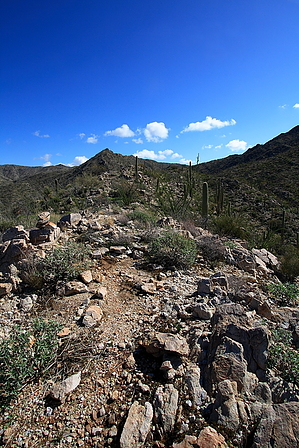
You might see a cochie on this hike by fricknaley  Overview OverviewThis is a route of interest for those hikers of the Tortolita Mountains. This is not a complete car-to-car description, rather a description to get you from the trailhead into Cochie Canyon and Cochie Spring, then up the ridgeline to traverse the Cochie Canyon/Wild Burro ridgeline and bring you back into Wild Burro Canyon via the Wild Mustang trail. Once meeting this trail, you have at least 3 (and potentially more) options of looping back to your car. Therefore, the end of the hike is left up to you as described below. The shortest loop hike for this one is 12.35 miles or so and it can be extended much beyond that. The connecting route is a purely off-trail bushwhack on a primitive hikers route and requires familiarity with the mountains. Hike As always this hike starts from the Wild Burro trailhead off Dove Mountain Blvd and requires the mandatory 1.3-mile walk up the wash, past the foolish Ritz-Carlton to the real trail network. This has been described by me on several other hikes here on HAZ (including the Wild Burro to Cochie Spring Hike), so briefly: take the Wild Burro Trail out of the gravel parking lot. It immediately drops down into the wide, sandy wash. This will take you into the mouth of the canyon. The trail itself snakes along the wash, crossing over and coming back. You can take the trail or just go straight up the wash, it doesn't really matter. The wash passes through a new high-end golf course and resort being built... we'll see how they preserve or reroute this passage in the near future. As you get closer to the mouth of the canyon, the vegetation perks up and the canyon walls slowly close in.
Take the Cochie Spring trail north as it continues to ramble across the hilltops, descending slightly through some magnificently huge saguaros. Soon the trail takes you by a drop-off where you can look northeast into the wide Cochie Canyon. Thereafter, the trail descends and west around a ridge(an old fence is encountered) before continuing back east and passing through a rickety old fence gate. You have now accessed the southern wall of Cochie Canyon. You will mostly continue along the wall of the canyon, heading northeast for about 2.5 miles. There are some ups and downs along the way. The trail crosses over several drainages feeding down the canyon wall. There are big, long views into the canyon and up the canyon all the way. You can see some old, presumably abandoned buildings in the wide wash floor, along with an inhabited ranch and some old dirt roads. This canyon has a long ranching history and there is still one active ranch in the canyon, the Carpenter Ranch. As such, you may well encounter some livestock along the trail. Ultimately the trail begins an earnest descent into the wash, where you will encounter the old Cochie Spring, with its requisite AERMOTOR CHICAGO windmill. From here, the route crosses over the wash and climbs up a short way along a well-defined path before coming to a small dam. Cross the dam and continue up along the trail for a few minutes. You may notice a small cairn and some pink tags in the trees on your right, marking the start of the traverse route, possibly along with a faint path. The spot is at 32.50875 N, 111.08888 W. Begin your bushwhack here. The route is going to basically head mostly east (and a little north) up a ridgeline to a small saddle, before climbing more seriously southeast up the canyon wall. There is a faint hikers route with some scattered cairns and possibly some tagged trees. Mostly make your way east up the ridgeline in front of you, climbing 0.8 miles to the small saddle between the last highpoint of the east heading ridge and the point where the route turns more southeast and climbs more severely. This little saddle is at 32.5116 N, 111.07734 W. From here you go mostly straight up 0.4 miles to the ridgeline separating the canyons and the highpoint of the hike at 4126 feet. The views are magnificent from here, including your first look at the Catalinas. From here you have a roughly 0.85-mile descent to the junction with the Wild Mustang Trail. The hiker's route along the south flank of the ridge is easier to follow than the climb so you may well be able to follow it without too much trouble (depending on your route finding skills). Descent Warning Forget, without too much trouble. Reportedly faint in 2018, possibly changed in 2020, a bushwhack in 2022 following one set of cairns. Pants might be a wise choice, among other protective gear/wear. The descent initially begins to the right (or southwest) before cutting back east and making a little cross country ramble through some fabulous saguaros, including a great crested saguaro, before meeting up with a wash and heading more strongly south. Once you hit this part, you may be able to look out over the wide Wild Burro Canyon floor to see where the wash lies. Continue down the route to ultimately hook up with the Wild Mustang Trail near a little brown sign naming it as such at a little wash crossing. This is at 32.50321 N, 111.06548 W. This is almost exactly 2 miles from the takeoff of the hiker's route. From here your choices include taking a left onto the Wild Mustang trail and hiking it about 0.65 miles to its end at the Alamo Spring. From here you can hike the Wild Burro trail back to the trailhead for your shortest hike of about 12.35 miles. You can take a right onto the Wild Mustang trail and hike it all the way back, past the Cochie Spring trailhead, and back to the junction with the Upper Javelina trail. Or you can take a left on the Wild Mustang, go the Alamo Spring and then hike the Alamo Spring trail roughly 5 miles back to the trail intersection and take the Wild Burro Wash back. The options are all worthy of a look. Please take caution on this hike, the connecting route may be easy to follow for some, but could lead others into confusion and getting lost in these desert mountains. Gate Policy: If a gate is closed upon arrival, leave it closed after you go through. If it is open, leave it open. Leaving a closed gate open may put cattle in danger. Closing an open gate may cut them off from water. Please be respectful, leave gates as found. The exception is signage on the gate directing you otherwise. Check out the Official Route and Triplogs. Leave No Trace and +Add a Triplog after your hike to support this local community. One-Way Notice This hike is listed as One-Way. When hiking several trails on a single "hike", log it with a generic name that describes the hike. Then link the trails traveled, check out the example. | |||||||||||||||||||||||||||||||||||||||||||||||||||||||||||||||||||||||||||||||||||||||||||||||||||||||||||||||||||||||||||||||||||||||||||||||||||||||||||||||||||||||||||||||||||||||||


