 Route Editor

| Guide | ♦ | 36 Triplogs | 1 Topic |
details | drive | no permit | forecast | route |
stats |
photos | triplogs | topic | location |
| 580 | 36 | 1 |
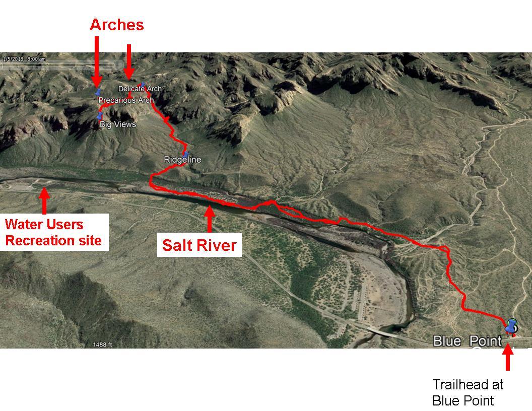
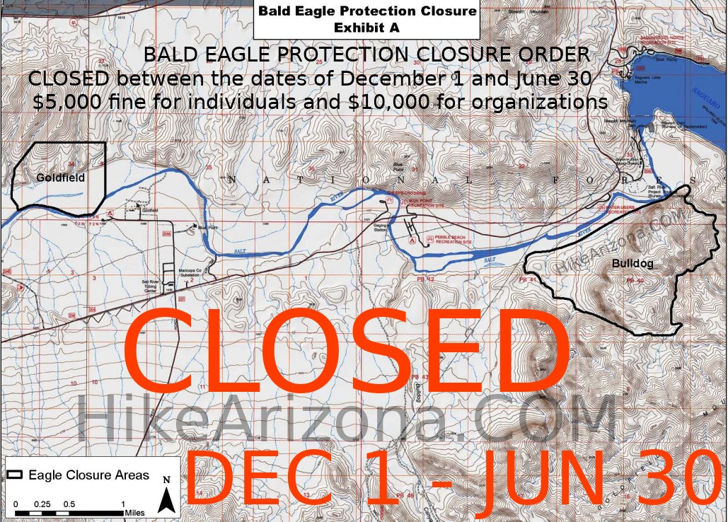
 Notice An area of this hike is closed Dec 1st - Jun 30th.  The Goldfield Mountains live in the shadow of their much younger and much more famous neighbor the Superstition Mountains. The Goldfields are a pleasurable alternative to the crowds of the Superstitions and provide many unique and varied vistas without a lot of other hikers to distract. This hike takes you to the even less visited river-high country with its connecting ridgeline vistas of the lakes, rivers, and mountains. Along the way are a variety of colorful rock formations and canyon foliage lining Gateway Canyon which opens up into a large, surprisingly level, plateau that is the staging point for further explorations or a destination of its own. The Goldfield Mountains live in the shadow of their much younger and much more famous neighbor the Superstition Mountains. The Goldfields are a pleasurable alternative to the crowds of the Superstitions and provide many unique and varied vistas without a lot of other hikers to distract. This hike takes you to the even less visited river-high country with its connecting ridgeline vistas of the lakes, rivers, and mountains. Along the way are a variety of colorful rock formations and canyon foliage lining Gateway Canyon which opens up into a large, surprisingly level, plateau that is the staging point for further explorations or a destination of its own.The hike begins at Blue Point Trailhead (N33 33 04 W111 34 54) which has a small parking area on the south side of Bush highway. The trailhead is just west of the Blue Point Bridge. After crossing the fence into the NF, there is a Forest service map and a jeep trail that leads south to Bull Dog Canyon. However, we take an immediate turn to the left (east) onto a trail that heads toward the mountains we will climb. This trail shortly turns onto a jeep road that goes southeast for about 0.6 miles until you reach a drop-off to the south flood plain of the Salt River(N33 32 46 W111 34 32). The view towards Saguaro Lake/Stewart Mountain Dam from the top of this drop-off is quite colorful in the winter when the trees are turning colors.
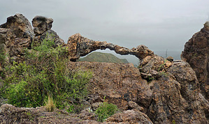
The goal is to head east about 1.5 miles until you cross under a high-voltage power line where you turn (N33 32 59 W111 33 11) towards the south looking for a small wash between two hills (N33 32 57.6 W111 33 04). The wash is pretty well hidden from view by mesquites so some searching may be needed. This small, flat, steep-sided, and brush-free wash serpentines between the two hills for a short distance before opening up into a wide valley. Just past the opening (N33 32 49 W111 33 04), there is an easy-to-miss cairn or two on the right marking the departure of the trail from the wash. The narrow-use trail goes west up a small hill and then turns south to follow the ridgeline (N33 32 46 W111 33 06). The trail is well cairned and the view into the drainage on your right is impressive. We found running water and small falls accented by huge cottonwoods when we passed by in March. The trail you are on leads to the high country while crossing the drainage once to get to the east side of Gateway Canyon. You will pass the mouth of Rhyodacite Canyon on the West at about the point where the trail becomes steep. As you follow the cairned trail up Gateway Canyon canyon, you look across at numerous caves and colorful rocks. These provide something to examine while you are pausing to rest during the climb. High and east along the skyline you will see what appears to be a large vertical arch that is just a chockstone. Oh yes, and while looking west, you may see the Fountain Hills fountain spouting its recycled water. After about 0.5 miles of steep climbing, you reach the destination of the high country plateau (N33 32 19 W111 32 11) where you can picnic, turn around, or head off to the many destinations that the high country offers. You don't want to miss the Delicate Arch which looks like 2 elephant trunks touching; this arch is on the overlook just to the northeast. Gate Policy: If a gate is closed upon arrival, leave it closed after you go through. If it is open, leave it open. Leaving a closed gate open may put cattle in danger. Closing an open gate may cut them off from water. Please be respectful, leave gates as found. The exception is signage on the gate directing you otherwise.
Check out the Official Route and Triplogs. Leave No Trace and +Add a Triplog after your hike to support this local community. | |||||||||||||||||||||||||||||||||||||||||||||||||||||||||||||||||||||||||||||||||||||||||||||||||||||||||||||||||||||||||||||||||||||||||||||||||||||||||||||||||||||||||||||||||||||||||||||||||||||||||


