 Route Editor

| Guide | ♦ | 142 Triplogs | 0 Topics |
details | drive | no permit | forecast | route |
stats |
photos | triplogs | topics | location |
| 146 | 142 | 0 |
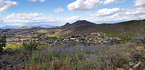
A Gem in Glendale by dbskip81  Overview OverviewFormerly known as H4 & H4-a. Now a multiple-leg trail. Originates at the North end of the amphitheater, or near Ramada 11. A branch of this trail originates at Ramada 11, travels west, and intersects the Coach Whip trail on the west side of the park. 2011 Hike This is a really fun hike that I enjoy doing almost every day. It's quick, easy, and a good workout at the same time. The trail goes to the top of a peak and there is a pretty good view of the whole park and the northwest valley.
A lot of hikes there intersect, so it would be easy to knock out a few of the trails here at once. This is a good hike to take your dogs and kids. The hike can be as hard as you want since a lot of the trails intersect. It's easy to make a loop out of the various trails. This trail at times can be a little busy, and I seem to run into the most people on this trail. One thing I noticed is I get a "hello" from almost everyone I pass. The map shows H-4 branching off to two trails, I take the one that goes up the mountain for a nice view. The top is about 1650 feet up. If you are going to hike this area, check the map and make a plan! Lots of trails to explore. Enjoy!
Check out the Official Route and Triplogs. Leave No Trace and +Add a Triplog after your hike to support this local community. One-Way Notice This hike is listed as One-Way. When hiking several trails on a single "hike", log it with a generic name that describes the hike. Then link the trails traveled, check out the example. | |||||||||||||||||||||||||||||||||||||||||||||||||||||||||||||||||||||||||||||||||||||||||||||||||||||||||||||||||||||||||||||||||||||||||||||||||||||||||||||||||||||||||||||||||||||||||


