 Route Editor

| Guide | ♦ | 174 Triplogs | 0 Topics |
details | drive | permit | forecast | route |
stats |
photos | triplogs | topics | location |
| 447 | 174 | 0 |
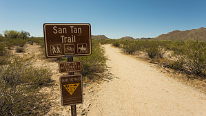
San Tan (Mountain Bike) Freeway by ferazamboni  The San Tan Trail is the longest loop trail in the San Tan Mountain Regional Park. The trail is primarily flat and wide, with minimal elevation gain. These features make it an attractive choice for visitors looking for a leisurely desert stroll, as well as mountain bikers looking to make some high-speed tracks. The San Tan Trail is the longest loop trail in the San Tan Mountain Regional Park. The trail is primarily flat and wide, with minimal elevation gain. These features make it an attractive choice for visitors looking for a leisurely desert stroll, as well as mountain bikers looking to make some high-speed tracks.There are three ways to access the San Tan Trail. The first and most direct access is from the park visitor center located at Phillips Road's end. To access the visitors center trailheads, you need to either pay per vehicle or opt to bike/walk in from outside the park entrance and pay a smaller fee. From this access point, the signed trailhead will take you clockwise through the loop. You may also opt to take the Littleleaf or Goldmine trails from the visitor center trailhead if you prefer to make the loop in a counter-clockwise fashion. The second access point is from the Goldmine trailhead located o Skyline Drive just west of Wagon Wheel Road. Taking this route will require you to hike the Goldmine Trail south until its junction with the San Tan trail after 1.5 miles. The third access point is from the Rock Peak Wash trailhead located off Brenner Pass Road near the park's southeast end. Access from this trailhead requires a 0.8-mile hike along the Rock Peak Wash trail until its junction with the San Tan trail. This trail description will be for the clockwise route starting at the visitor center.
From the junction with the Rock Peak trail, continue west on the San Tan trail. After 0.6 miles, you reach a junction with the Malpais trail. From here, there are lovely views of the mountains in the more remote southwest area of the park. If time (and energy) permits, the Malpais trail (4.2 miles) can be used to explore this area more closely and will connect back with the San Tan trail further north. From the Malpais junction, the San Tan trail continues north 0.7 miles to another junction with the west end of the Hedgehog Trail. From this junction, head west 0.2 miles to the junction with the north end of the Malpais trail, and then continue north 1.1 miles until a junction with the Moonlight trail. This is one of the more enjoyable sections of the San Tan trail because its location in the park feels remote, and the trail becomes more narrow. As a result, you will encounter fewer bikers and horseback riders in this area as those visitors tend to opt for shorter loops that stick to the wide trails. From the junction with the Moonlight trail, continue north along the San Tan trail for 1.5 miles until the next junction with the Goldmine trail. Along this section, you will enjoy lovely views of a large mountain range located just outside the park boundary in the Gila River Indian reservation. The final section of the San Tan trail follows the Goldmine trail and/or Littleleaf Trail back to the visitor center trailhead. The park visitors center has a nice memorial of the Arizona residents who lost their lives in Iraq and Afghanistan. A Desert Tortoise Habitat provides an up-close look at how these animals live and what they eat. The visitor center shop has a few items for sales as well.
Check out the Official Route and Triplogs. Leave No Trace and +Add a Triplog after your hike to support this local community. One-Way Notice This hike is listed as One-Way. When hiking several trails on a single "hike", log it with a generic name that describes the hike. Then link the trails traveled, check out the example. | ||||||||||||||||||||||||||||||||||||||||||||||||||||||||||||||||||||||||||||||||||||||||||||||||||||||||||||||||||||||||||||||||||||||||||||||||||||||||||||||||||||||||||||||||||||


