Route Editor

| Guide | ♦ | 53 Triplogs | 4 Topics |
details | drive | no permit | forecast | 🔥 route |
stats |
photos | triplogs | topics | location |
| 774 | 53 | 4 |
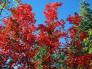
 Overview OverviewThis most pleasant and easy to navigate "off-trail" day hike or backpack within lush-green, large meadow-like "Upper Buck Spring Canyon" has much to offer: .. peaceful solitude and beauty as you enjoy a healthy forest environment of old-growth pines, spruce, sycamore, with an old cattle ranching roadbed spur (connecting to the main canyon) that offers a stunning hiking section of Big Tooth Maple Trees, that in our autumn season will make this hiking section alone worth the trip here; .. hiking between a high of 7729 feet elevation and a low of only 7480 feet makes this hike an excellent summer Flagstaff, Phoenix, or Tucson destination; .. possible deer, elk, and other wildlife sightings along this 6.5-mile round trip route; .. two perennial springs for viewing and/or backpack water sources- Upper Buck Spring and Lower Buck Spring plus numerous water seeps within this canyon hiking route; .. a visit to the historic Buck Spring Cabins Complex and its close by scenic water-dammed area; .. at Buck Spring Cabin Complex, easy access and connection to one of the five Mogollon Rim- Cabin Loop Trails (the Barbershop Trail#91 at its east TH Start); .. an easy day hike or backpack for the entire family; History Early in the 20th century, the trails we know of as the Cabin Loop was built by the early forest service. These days, there were few roads on the forest, and these trails served as a link between administrative sites and remote cabins used to house forest workers and fire patrols. One such cabin site is the Buck Springs Fire Guard Station, near the water source at Lower Buck Spring. As part of the "land of multiple uses" that the Forest Service espouses to, trails such as these became an early way for cattle ranchers to drive their herds to summer grazing locations. There is some evidence that Buck Springs Canyon was a popular area for cattle grazing long ago. Eventually, the forest road system was expanded, and old trails were not needed as much to access grazing areas such as this. Today, many of those roads still exist. Some are maintained and used regularly, and others are just overgrown roadbeds that haven't been driven in decades.
Perhaps indicative of the natural state of the area, you may encounter some researchers from the University of Montana's "Montana Cooperative Wildlife Research Unit" who spend a couple of months annually conducting a variety of studies in the area, focusing on avian life, climate change in high elevation ecosystems, and the exclusion of large herbivores in the riparian ecosystem. You may encounter several birdhouses along the hike as part of their study. Warning This easy to navigate day hike or backpack is recommended for the entire family, but being an "off-trail" use-route requires a good sense of hiking route direction. It is highly recommended that the safest and easiest way to hike this 6.5-mile round trip is to have/use adequate maps, own a GPS, and be able to download (and correctly follow) from HAZ our posted 10/2/10 "Official" GPS Route that begins hiking in from the "Drive to Option 1 (Preferred) TH/Parking" location off FR161B. Hike Description GPS coordinates for all "key" waypoints should also be loaded in your GPS Receiver. Also, as with all AZ-Mogollon Rim hikes, this one being no exception, plan accordingly and use caution if you are hiking this area during our summer Monsoon season. Hike This hike begins at the Parking/TH Start location described in the hike driving direction section. From here, hike the approximate 50 yards to the intersection of FR137/643A and cross over FR137 and hike due east, through this easy to navigate forest section, downhill for .20 mile to connect with old, unsigned ranching roadbed "FR9714V" at waypoint N34.41882 W111.14828 (Note: if you are not using a GPS with our 6/19/10 default hiking route loaded in your unit for reference, then you will need to take note of your entry point at FR9714V for your later return trip exit back up to FR137 and your vehicle). Begin hiking north (down) this Upper end of Buck Spring Canyon for a total of .75 mile to view the perennial source of "Upper Buck Spring" at waypoint N34.42615 W111.14761; From here, your hike continues down the canyon on the right (east) canyon side for a total of 1.0 mile where you will intersect (a right turn-southwest) one of this trips main highlights, the old cattle ranching roadbed spur that offers a stunning autumn hiking section of "Big Tooth Maple Trees." Continue first SW, then south up this scenic roadbed spur to its end (a total of 1.75 miles in from your TH Start location). Return to the main canyon via this roadbed spur and continue to hike north (down canyon) on the canyon's east side. Here you will see and be hiking on the old, main ranching roadbed that once ran the entire length of this upper canyon section. At a total of 2.90 miles, you will reach the fenced-in "Riparian Study Area" of Upper Buck Spring Canyon.. follow the use trail along the east side of the fence. At a total of ~3.40 miles, you will begin to see the historic "Buck Spring Cabin Complex" on the canyon west side. Here you will need to crossover to the canyon west side to enter the cabin complex area, a great location for a snack or lunch break and some meandering-around (It should be noted that depending on the season and recent weather, finding a dry crossing spot from the east side to west side may be a challenge). Behind the two historic cabins and just past the entrance road gate (to the left of the gate), you will see the east TH Start for Cabin Loop Trail- "Barbershop Tr#91". From here, continue to follow the entrance road to the large parking lot area and on to cross into the "Lower Buck Spring Water Dammed Area" for viewing; From here, you continue to follow the east side of the dammed drainage area, hiking NE over a forest road to locate the source of perennial "Lower Buck Spring" (a cement enclosure within a fenced-in area) located at N34.44459 W111.13738 You should be a total of ~4.10 miles into your hike at this point. This is the far NE end of this round trip hike. At this perennial Lower Buck Spring water source, your return hike is via retracing your route in Buck Spring Canyon heading south (up canyon), hiking back to your TH Start on the scenic "west side" (right side) of the canyon. Water Sources Perennial Upper and Lower Buck Spring, dammed water area at Buck Spring Cabin Complex, plus numerous water seeps along this canyon hike (water should be chemically treated and/or filtered before drinking). Camping Numerous primitive backpack campsite possibilities within this 6.5-mile round trip hike. Gate Policy: If a gate is closed upon arrival, leave it closed after you go through. If it is open, leave it open. Leaving a closed gate open may put cattle in danger. Closing an open gate may cut them off from water. Please be respectful, leave gates as found. The exception is signage on the gate directing you otherwise. Check out the Official Route and Triplogs. Leave No Trace and +Add a Triplog after your hike to support this local community. | |||||||||||||||||||||||||||||||||||||||||||||||||||||||||||||||||||||||||||||||||||||||||||||||||||||||||||||||||||||||||||||||||||||||||||||||||||||||||||||||||||||||||||||||||||||||||||||||||