 Route Editor

| Guide | ♦ | 34 Triplogs | 0 Topics |
details | drive | permit | forecast | route |
stats |
photos | triplogs | topics | location |
| 65 | 34 | 0 |
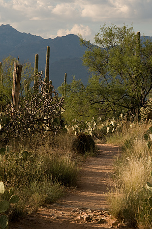
Deep History by keepmoving  Overview OverviewLoma Verde Trail runs 2.3 miles from the Loma Verde Trailhead on Cactus Forest Loop to the Shantz Trail near Speedway Blvd. Along the way, you will have great views of Mt. Lemmon, Mica Mountain, and Tanque Verde Peak, as well as passing the historic Loma Verde Mine. Hike From the Loma Verde Trailhead, follow the trail as it winds its way north through the trees. In rapid succession, you will encounter Mesquite, Squeeze Pen, Monument Wash, and Cholla Trail. Past Cholla Trail, the desert opens up, and you are treated to great views of the Tucson basin and the surrounding mountains. At 0.7 miles from the trailhead, you will encounter a sign posted on your left that announces your arrival at the Loma Verde Mine. While the mine has been filled in and no longer looks like much, according to the NPS, it reached a depth of 350 feet in 1902!
Continuing north from Pink Hill, the trail continues along its mostly northward path as it heads gently downhill. The grade is so gradual that it's almost impossible to tell you are losing elevation. Soon you will encounter a signed intersection on your left for the western section of Vanover Trail, followed by an additional sign on your right 0.2 miles further north for the eastern portion of Vanover Trail. Heading north past the second intersection with Vanover Trail, Loma Verde will begin to lose elevation more rapidly. Soon you will drop into a tree-lined area where you will encounter the terminus with Shantz Trail. You can return the way you came or use one of the many other trails in the area to form your own loop. Cumulative Mileage From Loma Verde TH:
Check out the Official Route and Triplogs. Leave No Trace and +Add a Triplog after your hike to support this local community. One-Way Notice This hike is listed as One-Way. When hiking several trails on a single "hike", log it with a generic name that describes the hike. Then link the trails traveled, check out the example. | ||||||||||||||||||||||||||||||||||||||||||||||||||||||||||||||||||||||||||||||||||||||||||||||||||||||||||||||||||||||||||||||||||||||||||||||||||||||||||||||||||||||||||||||||||||||||||||||||||||||||||||||


