Route Editor

| Guide | ♦ | 8 Triplogs | 1 Topic |
details | drive | no permit | forecast | 🔥 route |
stats |
photos | triplogs | topic | location |
| 57 | 8 | 1 |
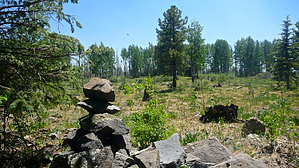
Higher because it's green! by chumley  Overview OverviewThis hike is absolutely unnecessary for anybody who isn't trying to gain all 15 Arizona county high points. There is no other reason to hike here. The high point is located less than 1/4 mile east of the Coronado Trail (US-191), about 1 mile north of the turn for KP Cienega Campground. But parking and hiking access is best from the FR8839 road, a quarter-mile farther north.
From the junction of unsigned FR8839 and the highway, hike south on the old roadbed. As of 2014, the road was littered with deadfall from the 2011 Wallow Fire. Nonetheless, the road is a better option than off-trail hiking directly toward the peak*. After about .35 miles on the road, turn right and head straight up the gentle slope. The deadfall will keep you busy, but eventually, you break through to an open grassy area, and a 2-foot cairn indicates the high-point tucked just below some pine trees. The cairn is easily spotted from the south. It is more hidden if looking for it from the north and east. There is no trail, and the fire damage makes this slightly challenging. Anybody who has been visiting Arizona's County High Points will have absolutely zero problem gaining this one. But it is a bit of an obstacle course through downed trees, which will hopefully improve as the years go by. *This has been classified as a peak due to it's county high-point status. But at a gain of 115 feet and no views to be seen, it is certainly not what most people would consider a peak. Check out the Official Route and Triplogs. Leave No Trace and +Add a Triplog after your hike to support this local community. | |||||||||||||||||||||||||||||||||||||||||||||||||||||||||||||||||||||||||||||||||||||||||||||||||