 Route Editor

| Guide | ♦ | 9 Triplogs | 0 Topics |
details | drive | permit | forecast | 🔥 route |
stats |
photos | triplogs | topics | location |
| 22 | 9 | 0 |
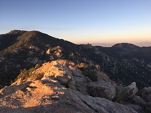
 Overview OverviewFrom specific vantage points on Mt Lemmon, you can see Lizard Rock, an iguana-shaped rock near Windy Point. This is a nice quick hike to the top of Lizard Rock, where you will be treated to fantastic views of the Tucson area, from the Rincons to Baboquivari Peak. Although no official trail exists, the area sees frequent traffic, as evident by the various use trails that wind their way to the top. Hike From the parking pullout, get out of your vehicle and head west. While your destination is hidden from view at this point, your goal is to pick one of the use-trails, or a drainage, and begin to work your way up the ridgeline. Make sure to stay towards the middle of the ridge, as this is the easiest path to the top. The hike through this area is composed of loose sand and rock that can make the footing a little tricky.
Check out the Official Route and Triplogs. Leave No Trace and +Add a Triplog after your hike to support this local community. | ||||||||||||||||||||||||||||||||||||||||||||||||||||||||||||||||||||||||||||||||||||||||||||||||||||||||||||||||


