Route Editor

| Guide | ♦ | 6 Triplogs | 1 Topic |
details | drive | no permit | forecast | 🔥 route |
stats |
photos | triplogs | topic | location |
| 141 | 6 | 1 |
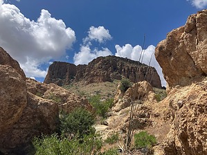
Buffalo Butte? by John10s  Overview OverviewPeak 4054 is a rugged off-trail summit that offers fantastic 360° views including the White Canyon Wilderness, Picketpost Mountain, the Superstitions, and Wood Canyon. The majority of the hike follows a jeep road and a creek bed, then circles to the west side of the peak for a final ascent up a steep chute. Note The official route and this description start from a small pullout near a cattle guard along an unnamed jeep road at 33.247457, -111.109294. High clearance is recommended to reach this point, but 4x4 isn't necessary unless there's been recent rain. Depending on vehicle capability and road conditions, you can continue following this road to shorten the hike. The posted driving directions continue ~1.7 miles beyond the starting point described here, but note that 4x4 may become preferable depending on how far you follow the road.
From the cattle guard, follow the unnamed road as it curves to the south, then quickly turns to the east for a short distance. Along this stretch, you'll pass some stacked-rock walls, possibly built by nearby ranchers to manage livestock. As the road curves to the south again, you'll get your first views of the intriguing geology around Wood Canyon, an area full of unique formations, small arches, alcoves, and caves. The yellowish rock is similar to the geology in parts of the Goldfields. Unfortunately, it also shares another similarity with the Goldfields--if you look closely, you'll see graffiti on some of the rocks. A little over a mile into the hike, you'll pass a water tank on the west side of the road, and a short distance beyond that, the first cave appears on the east side of the road. There's another similarly-sized cave farther off the road less than a quarter mile south. Along this stretch, you're approaching Peak 3820, which sits just east of the road. As you pass the peak, the canyon narrows and the road leads through an area with more boulders and larger pools of water, then parallels a cliff wall with some interesting overhangs at the base. Looking to the south along this stretch, you'll get your first views of Tower Arch in the distance, located near the top of a large butte. Further along the road, ~2.75 miles into the hike, you'll pass a creek bed that branches off to the left--this is the start of the White Canyon via Wood Canyon route. Continue on the road as it gradually deteriorates, leaving you following the creek bed. Around 3.25 miles in, you'll see several appealing spots to leave the creek bed to hike up to the butte with Tower Arch--a short and worthwhile addition to the hike if you have time. Following the creek bed, you'll pass more interesting and colorful geology below the Tower Arch butte. Peaks 3925 and 3985 are two of the higher points to the northwest, and the destination, Peak 4054 looms ahead. Viewing the peak from this angle, it appears to be surrounded by sheer cliffs on all sides, but the west side offers a relatively easy ascent. Choose a spot to leave the creek bed and approach the west side. Depending on the season, you may encounter thick grasses, but most of the brush is free of thorns. There are some small rock outcroppings but no major obstacles to avoid, so there's plenty of flexibility in choosing a route. Once you've worked your way around to the southwest side of the mountain, you'll find a steep chute that provides the best access point to the summit. Navigating the chute requires some hand use and light scrambling, but nothing more than light class 3 at most. At the top of the chute, turn right/south and scramble up a short distance to reach the high point. From the summit, you'll have fantastic views of the White Canyon Wilderness to the south, with Battle Axe Butte standing out as a particularly distinctive feature. To the northeast, you can see the butte with Tower Arch as well as Superior and the cliffs of Apache Leap beyond. Looking northwest, Picketpost is a major landmark, with the Superstitions beyond and Weaver's Needle just barely visible over the mountains. In the summit cairn, you'll find an old register, placed in February 1979. The peak doesn't get much traffic, with gaps of several years between many of the entries. In a 2009 entry, someone mentioned that locals call this peak Buffalo Butte, though I haven't seen that confirmed anywhere. After enjoying the spectacular scenery, you can return via the same route or extend the hike by exploring more of the seemingly endless peaks and features in the area. Check out the Official Route and Triplogs. Leave No Trace and +Add a Triplog after your hike to support this local community. | |||||||||||||||||||||||||||||||||||||||||||||||||||||||||||||||||||||||||||||||||||||||||||