username
X
password
register
for free!
help


Dragoon Marble Quarries, AZ

Guide 4 Triplogs  1 Topic
  2.3 of 5  
Fav
Wish
1
details
drive
permit
forecast
map
stats
photos
triplogs
topic
location
17 4 1
Statistics
tap row or icons for details
Difficulty 1 of 5
Distance Round Trip 1.4 miles
Trailhead Elevation 5,208 feet
Elevation Gain 330 feet
Accumulated Gain 350 feet
Avg Time Round Trip 1 hour
Kokopelli Seeds 3.15
 Backpack Possible - Not Popular
feature photo
Photos Viewed All MineFollowing
10  2011-05-01 johnlp
7  2011-01-12 PrestonSands
Author
author avatar Guides 170
Routes 148
Photos 5,914
Trips 2,097 map ( 11,156 miles )
Age 48 Male Gender
Location Tucson, AZ
Associated Areas
list map done
Tucson Region
Historical Weather
Trailhead Forecast
Expand Map
Preferred Mar, Nov, Apr, Oct
Seasons   ALL
Sun  5:58am - 6:38pm
0 Route
 
0 Alternative


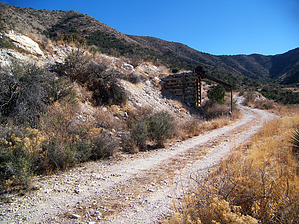
Quarry your own tombstone and save.
by PrestonSands

 
Overview
First off, nothing is exciting about this hike, unless you are interested in geology. It is just a short road hike to a cluster of small, abandoned marble quarries on the north slope of the Dragoon Mountains. Drive in as far as you like on Forest Road 689, park, and hike. These marble quarries, while not as interesting as the historic Arizona Marble Company quarry near Fort Bowie, are at least on public land.


History
In 1909 marble was discovered in a canyon on the north slope of the Dragoon Mountains, just a few miles from the town of Dragoon. The claim, situated atop a slice of metamorphosed Mississippian Escabrosa Limestone, did not produce until 1953. Small scale mining by Ligier-Arizona Marble Quarries, Inc, and its successor, Dragoon Marble Quarries, continued as late as 1981, mostly producing marble for landscaping purposes.
remove free decal offer
Hike
From whatever point you decide to park along Forest Road 689, continue south up the road on foot. The road leaves the mountain pediment and climbs into a canyon of sotol and chaparral, where the first quarry, appearing as a small white pit, is located. The road becomes rougher after passing some sort of loading structure and makes a switchback to the left. Continue north from the switchback to the main quarry area. There are several pits here, where sparkling snow white and pale grey marble were removed from the earth. From this area, one can look down across the grassy plains of Dragoon Pass to the rocks of Texas Canyon in the distance. Return the same way.

2011-01-18 PrestonSands


    Check out the Triplogs.
    Leave No Trace and +Add a Triplog after your hike to support this local community.
    WARNING! Hiking and outdoor related sports can be dangerous. Be responsible and prepare for the trip. Study the area you are entering and plan accordingly. Dress for the current and unexpected weather changes. Take plenty of water. Never go alone. Make an itinerary with your plan(s), route(s), destination(s) and expected return time. Give your itinerary to trusted family and/or friends.

     Permit $$
    None

    Coronado Forest
    MVUMs are rarely necessary to review unless mentioned in the description or directions
    Coronado Motor Vehicle Use Maps (MVUMs)


     Directions
    or
     Road
    FR / Jeep Road - Car possible when dry

    To hike
    From Tucson, travel east on Interstate 10 past Benson, and take exit 318 (Dragoon Road). Turn right onto Dragoon Road, and follow it for 5.1 miles to North Lizard Lane on the right, at highway milepost 5. Turn right (south) onto N Lizard Lane and follow it due south across private land to the National Forest boundary at 0.6 miles, where the road crosses a cattle guard and becomes Forest Road 689 (note the little brown "689" sign on the fence). Continue driving south along Forest Road 689 for as far as you like, then park and hike. The road becomes steeper and rougher (high clearance) as you approach the quarries (the first quarry is 1.7 miles past the Forest boundary). Please be respectful of the private land along North Lizard Lane so that the landowners will continue to allow Forest access here.
    page created by PrestonSands on Jan 18 2011 11:52 pm
     90+° 8am - 6pm kills
    helpcorrectionissue

    end of page marker