Route Editor

| Guide | ♦ | 6 Triplogs | 0 Topics |
details | drive | permit | forecast | route |
stats |
photos | triplogs | topics | location |
| 75 | 6 | 0 |
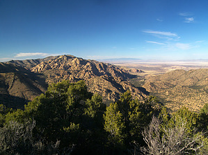
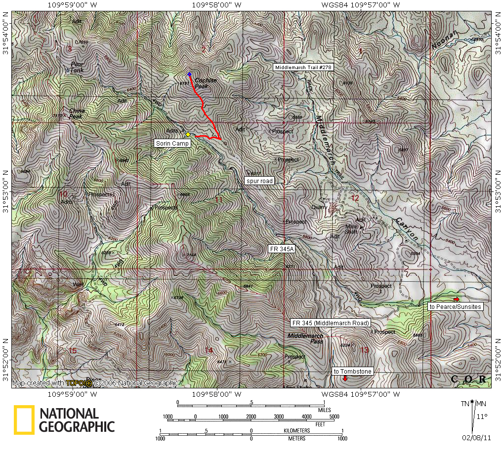
Sorin' with Cochise by PrestonSands   Overview OverviewCochise Peak, in the central portion of the Dragoon Mountains, is reached by a relatively easy off-trail hike. One can look down at Cochise Stronghold, and enjoy a fine view of the Sulphur Springs Valley from its 6797-foot summit. The hike described below begins at the turnoff for Forest Road 345A (Sorin Camp Road). If you choose to drive Forest Road 345A (high clearance 2wd), rather than hike it, you can cut this hike down to 1.5 miles and 733 AEG round trip.
In 1883, Tombstone miner Thomas Sorin purchased two copper claims in a canyon that would eventually bear his name. He constructed a five-room adobe cabin, dug two wells, and planted a large orchard in the canyon bottom. When Sorin's mining claims failed to produce, he devoted his attention to constructing a toll road over Middlemarch Pass and cutting firewood to sell in Tombstone. After many years spent in the mountains, Sorin passed away at his camp in March 1923 and was buried in Tucson. His home away from home, at the southern base of Cochise Peak, came to be known as Sorin Camp. Today Sorin Camp can be identified by a windmill and an old rock well, only a few hundred feet up canyon from the route of this hike. Hike Turning off of Middlemarch Road onto Forest Road 345A, hike or drive up Sorin Canyon. The road soon leaves the mountainside behind to travel along the floor of Sorin Canyon, among plentiful oak and alligator juniper trees punctuated by the occasional spiny yucca. After 1.3 miles of rough and rocky road, the turnoff for Cochise Peak appears as a side road on the right (north). If you reach the windmill at Sorin Camp you have gone a bit too far, just backtrack a few hundred feet to the turnoff at 31.88873 N, -109.96916 W. The side road climbs out of the canyon and reaches the top of a ridge in just under 0.2 miles. As soon as you reach the ridge, turn around to see Cochise Peak. Leave the side road at this point, and head northwest along the top of the ridge toward the peak. Cochise Peak appears deceptively close, but there is a half-mile of thorny plant life and steep terrain to go. Following the barbed wire fence is helpful, but you shouldn't get disoriented here, as the terrain is fairly open. Footing is tricky though, with knee-deep grass hiding a steep surface of loose rounded rocks. At 6797 feet, you'll top out on Cochise Peak's flattened summit. Enjoy the view and sign the register. For an even better view, head northwest across the summit to its northern edge, where you can look out across the rocks of Cochise Stronghold (Stronghold view coordinates are 31.89485 N, -109.96988 W). Camping There are a few roadside campsites along Forest Road 345A, and on top of the ridge on the spur road to Cochise Peak. Cochise Peak itself has a potential small campsite in the trees a short distance north of the summit cairn.
Check out the Official Route and Triplogs. Leave No Trace and +Add a Triplog after your hike to support this local community. | ||||||||||||||||||||||||||||||||||||||||||||||||||||||||||||||||||||||||||||||||||||||||||||