 Route Editor

| Guide | ♦ | 56 Triplogs | 0 Topics |
details | drive | no permit | forecast | 🔥 route |
stats |
photos | triplogs | topics | location |
| 508 | 56 | 0 |
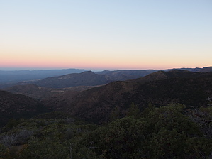
From Highlands to Grasslands by jacobemerick   Overview OverviewSurprisingly diverse trail that samples a wide range of Mazatzal environments, from the manzanita and pine highlands to prickly grasslands. The first few miles were damaged during the Sunflower Fire - otherwise, much of the area is untouched and rather enjoyable. This trail is part of several great loops and destinations (Copper Camp Loop, Plateau Overlook, Sheep Creek Cabin, Davenport / Sears Loop) and is rarely done in its entirety. Hike The southern end of the trail continues the AZT after Saddle Mountain Trail leaves for a short, aimless loop through some old mining territory. Heading north, Sheep Creek Trail crosses a small drainage, follows the side of a ridge, and then drops sharply down into McFarland Canyon. At the base of this drop, there is a pleasant campsite nestled under towering pines, complete with a nearby water source. These 0.6 miles are well-maintained, offer good views, and is easy to follow, but this is where Sheep Creek Trail leaves the AZT and heads west to more rugged lands.
An unsigned junction with Copper Camp shows up at 1.5 miles. The trail takes a sharp right here and climbs up the hill, switching back and forth with sharp twists. A reward at the top is a great view of Saddle Mountain to the south and Sheep Mountain to the north. Then, a tree-lined rocky creek shows up a short distance later, marking the boundary of Sunflower Fire, and the rest of the trail stays outside of any burn areas. For a while the tracks bounces up and up some hills, climbing up an annoying distance for a 'flat', before it hits the drop-off at 2.2 miles and offers jaw-dropping views of the western Mazzies. Now it's time to drop down into Sheep Creek. Over the next 0.8 miles, the trail plummets a thousand feet over sharp switchbacks, with only a small hillock reprieve near the middle. Much of the hillside here is mature manzanita with a few small trees. At the base is a rocky tributary to Sheep Creek surrounded by tall pines and deciduous trees. The trail sticks to the west bank for a short distance before crossing a few times, though the crossings are not always easy to make out. If in doubt there is always the rocky creekbed that can be used as an ad-hoc route. Near 4.4 miles there is some signs of an old corral on the east bank - by this point the trail has fully committed to the east side and the forested banks have transitioned to brushy grassland. Round Spring and the site of Sheep Creek Cabin show up on the main fork of Sheep Creek at 5.1 miles. The remains of the cabin are a bit east of the trail, and there are some cool knick-knacks still floating around the area. This is the point the trail leaves the creeks behind and hauls up a short hill and is poorly defined. At the top there is a rather intact corral... The junction of Sheep Creek Trail and Sears Trail is near the northwest corner, and while the sign may be difficult to find, the corral makes for a decent marker. From here the trail swings north and heads up to a small saddle, drops a short distance, and then follows along the hillside further north, dropping slightly as it swings in and out of a few little drainages. The cairns and tread here are small and hard to make out, often competing with game tracks for the easiest way forward. At 6.1 miles it makes a sharp turn downhill and follows a ridgeline composed mostly of rolling rocks to the tributary below. After a quick crossing and back the trail stays on the west bank, which gets increasingly more choked with catclaw, before passing an overgrown corral, crossing Bear Creek, and then hauling up a short ridge. On top of the ridge the last obstacle comes into view - the conflux of Mazatzal Wash into Davenport Wash. To drop down to this point the trail first makes a quick twist to the right in order to use an east ridgeline. At the bottom of the ridgeline there is a quick crossing of Mazatzal Wash, then an overgrown jog to skip the conflux, and then another quick crossing of Davenport Wash. The trail follows the bank for a short section before climbing up the long hill towards Rock Spring. The final few dozen yards is a fun, rolling trek, and then the junction with Davenport Wash Trail shows up. From here it is over nine downhill miles to Sears Trailhead or less than two uphill miles to Club Cabin. Water Sources McFarland Spring sits near the southern end of the trail. There are a few spots along the tributary to Sheep Creek that may have water, between the spot the trail first meets it and Sheep Creek Seep, plus Round Spring and the cabin area. Club Spring is the most reliable source beyond the northern terminus. Camping McFarland Spring has the most established campsite, sitting right along the AZT. There is a clearing near Squaw Flat Spring and several potential sites along the tributary to Sheep Creek. Round Spring, and the old cabin site, have a few pleasant spots. North of that the best campsite is probably Club Cabin beyond the end of the trail. Check out the Official Route and Triplogs. Leave No Trace and +Add a Triplog after your hike to support this local community. One-Way Notice This hike is listed as One-Way. When hiking several trails on a single "hike", log it with a generic name that describes the hike. Then link the trails traveled, check out the example. | |||||||||||||||||||||||||||||||||||||||||||||||||||||||||||||||||||||||||||||||||||||||||||||||||||||||||||||||||||||||||||||||||||||||||||||||||||||||||||||||||||||||||||||||||||||||||||||||||||||||||||||||||||||||||||


