 Route Editor

| Guide | ♦ | 16 Triplogs | 1 Topic |
details | drive | no permit | forecast | 🔥 route |
stats |
photos | triplogs | topic | location |
| 119 | 16 | 1 |
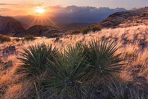
..Be Remote in The Mazatzals.. by Grasshopper  Summary SummaryThis "in and out" hike in our Central Mazatzal Wilderness starts at the Mormon Grove TH and takes you five miles into this wilderness area via 3.0mi on the scenic Saddle Mtn Trail#91 and another 2.0mi on the historic Sheep Creek Trail #88 BEFORE connecting with remote inner trail- The Copper Camp Trail #87 for another 2.53mi to a Plateau Overlook Point at 4680' elev to view the rugged/remote and scenic Southwest Mazatzal Wilderness with its deep & distant drainages to Bartlett Lake and beyond to the Verde River. Note For the first five miles of this hike, see details of HAZ Guide Saddle Mountain via Mormon Grove TH.
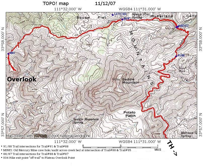
Five miles in from the Mormon Grove TH, at the intersection of the Sheep Creek Tr#88 in Squaw Flat, the published 7-mile one way Copper Camp Tr#87 begins at 5200' elev as it makes its way WNW through the Central Mazatzals to its terminus point on FR477 (close to the Verde River) at 2600' elevation. From this above starting point with the Sheep Creek Tr#88 at Squaw Flat, the Copper Camp Tr#87 begins as an easy to follow trail with a steady uphill through large Gambel Oaks, Sumac and healthy Cedars to ridgeline overlooks with grand views of Bartlett Lake, Saddle Mountain, Sheep Mountain, and Mount Peeley as you parallel the Mazatzal Divide Trail #23 over to the Northeast. The ridgeline "high point" of your hike on this Copper Camp Trail is 5475'; before starting the continuous downhill portion. At 1.61mi in on this TR#87(at 5310' elev), you will round a corner to the left and VIEW (at approximately 11:O'Clock location) in the distance, your hike ending point at the large "off-trail" Plateau Overlook Point at 4680' elevation. Now continue hiking Tr#87 downhill, looking closely for trail cairns to mark the trail way until you reach the 2.2-mile distance at GPS coordinates: N33 57.829 W111 32.836 at 4800' elevation. Key Stop here and turn left to begin your 0.33mi off trail hike: First skirt around the small hill- then you will clearly view the Plateau Overlook Ending Point ahead of you at 4680' elevation. This is a rocky, grassy yet relatively flat, and easy short off-trail. It's an 0.33mi/~15 minute hike to a very nice ending overlook. Here you'll witness some of the most remote views and drainage sections of our rugged Mazatzal Wilderness Areas... Enjoy!! At this recommended ending point, you are now 7.53mi in from your beginning TH. Reverse your route from the way you came in and head back to your beginning Mormon Grove TH. Referenced on the map: o 91/88 Trail intersections for Trail#91 & Trail#88 o MINE1 Old Mercury Mine cave hole/audit across creek bed at intersection of Trail#88 & Trail#95 o 88/87 Trail intersections for Trail#88 & Trail#87 o 004 Hike exit point "off trail" to Plateau Overlook Point Check out the Official Route and Triplogs. Leave No Trace and +Add a Triplog after your hike to support this local community. | ||||||||||||||||||||||||||||||||||||||||||||||||||||||||||||||||||||||||||||||||||||||||||||||||||||||||||||||||||||||||||||||||||||||||||||||||||||||||||||||||||||||||||||||||||||||||||||||||||||||||||||||||||||||


