username
X
password
register
for free!
help
 This is likely a great time to hike this trail!  Check out "Preferred" months below, keep in mind this is an estimate. 
  

Ladybug Peak 8780, AZ

Guide 59 Triplogs  0 Topics
  3.4 of 5  
Fav
Wish
0
details
drive
permit
forecast
route  
stats
photos
triplogs
topics
location
226 59 0
Statistics
tap row or icons for details
Difficulty 1 of 5
Distance Round Trip 0.9 miles
Trailhead Elevation 8,498 feet
Elevation Gain 256 feet
Accumulated Gain 256 feet
Kokopelli Seeds 2.18
 Interest Peak
unreported if dogs are allowed
editedit > ops > dogs to adjust
feature photo
Photos Viewed All MineFollowing
Inaugural Calculation on Button Tap!
20  2024-09-29
Moonshine - Heliograph - Ladybug
The_Eagle
13  2024-09-29
Moonshine - Heliograph - Ladybug
trekkin_gecko
11  2024-09-29
Moonshine - Heliograph - Ladybug
johnlp
3  2022-09-05 chumley
8  2022-09-05 BiFrost
12  2022-08-06
Ladybug Peak from Turkey Flat TH
Jim
16  2019-07-19
Bear Canyon Trail #299 Upper
markthurman53
4  2018-09-01 chumley
Page 1,  2,  3
Author
author avatar Guides 16,843
Routes 17,472
Photos 24
Trips 1 map ( 6 miles )
Age 28 Male Gender
Location HAZ, TrailDEX
Associated Areas
list map done
Tucson Region
Historical Weather
Trailhead Forecast
Radar Map
Expand Map
Preferred Sep, Aug, May, Jul
Sun  5:57am - 6:39pm
Official Route & 4 Rts
 
6 Alternative


remove free decal offer

 Likely In-Season! 
Guide Needed
Publish Full Detail Guide


Use +Add above to share photos and triplogs
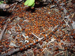
Overview: A short 1 mile round trip hike up to the peak where at certain times of the year ladybugs can be found on top by the thousands.


    Check out the Official Route and Triplogs.
    Leave No Trace and +Add a Triplog after your hike to support this local community.
    WARNING! Hiking and outdoor related sports can be dangerous. Be responsible and prepare for the trip. Study the area you are entering and plan accordingly. Dress for the current and unexpected weather changes. Take plenty of water. Never go alone. Make an itinerary with your plan(s), route(s), destination(s) and expected return time. Give your itinerary to trusted family and/or friends.

     Permit $$
    no fees or permits reported

    if incorrect tell us about it

    Coronado Forest
    MVUMs are rarely necessary to review unless mentioned in the description or directions
    Coronado Motor Vehicle Use Maps (MVUMs)


     Directions
    or
     Road
    Paved - Car Okay

    To hike
    From Safford - Travel south on US 191, turn west onto Hwy 366 (Swift Trail) and take it approximately 16.75 miles to the large paved pulloff at Ladybug Saddle.
    page created by SkyIslander18 on Apr 29 2011 10:04 pm
     90+° 8am - 6pm kills
    helpcorrectionissue

    end of page marker