 Route Editor

| Guide | ♦ | 35 Triplogs | 0 Topics |
details | drive | no permit | forecast | route |
stats |
photos | triplogs | topics | location |
| 46 | 35 | 0 |
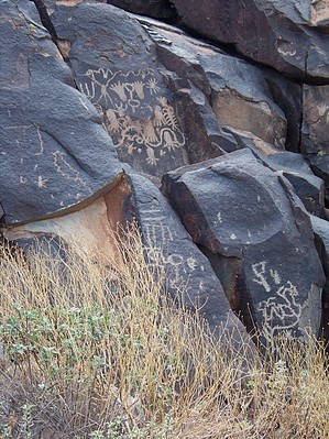
Scenic Stroll by joebartels   Note NoteThere is currently no signage stating anyone is unwelcome or even that it's a trailhead, for that matter. Lost Creek Trailhead is a "community" trailhead, according to Verrado. It sounds like a step up from nearby Victory Trailhead, which Verrado dubs a "neighborhood" trailhead. The entire area is still in major development as of Sep 2021. It seems like it will all eventually gel; just beware of the final line of their pdf: All proposed trails and trailheads are subject to change at any time, including removal all together. Hike From the end of Lost Creek Drive, walk east as if the road continued. Soon you cross over a wide sidewalk for golf carts. The trail begins at a small parallel fence walk-through. At 0.1 mi (within minutes), turn left just before an old road intersection. You merge southbound onto a road-width path that soon turns east. The road-width path crosses a wide dry creekbed. At 0.3 mi is the final route-finding of concern. Turn right and stay on the road-width path to the petroglyph site. Narrow use-trails are nearby, but the wide old jeep road is the official trail. A fence topped with concertina wire surrounds the petroglyph site.
The sharp lines of the foothill ridges along with better than average desert foliage are the highlight of the short journey. Parking is very limited and popular on cool mornings.
Check out the Official Route and Triplogs. Leave No Trace and +Add a Triplog after your hike to support this local community. One-Way Notice This hike is listed as One-Way. When hiking several trails on a single "hike", log it with a generic name that describes the hike. Then link the trails traveled, check out the example. | ||||||||||||||||||||||||||||||||||||||||||||||||||||||||||||||||||||||||||||||||||||||||||||||||||||||||||||||||||||||||||||||||||||||||||||||||||||||||||||||||


