username
X
password
register
for free!
help


Quantrell Mine Trail, AZ

Guide 29 Triplogs  0 Topics
  2.8 of 5  
Fav
Wish
1
details
drive
permit
forecast
route  
stats
photos
triplogs
topics
location
195 29 0
Statistics
tap row or icons for details
Difficulty 2.5 of 5
Distance Round Trip 5.3 miles
Trailhead Elevation 4,571 feet
Elevation Gain 551 feet
Accumulated Gain 1,217 feet
Avg Time Round Trip 3 hours
Kokopelli Seeds 11.39
 Interest Historic, Seasonal Waterfall & Seasonal Creek
 Backpack No
feature photo
Photos Viewed All MineFollowing
Will recalculate on button tap!
7  2024-03-14
Little Elephant Head - Santa Rita Mtns
fricknaley
8  2022-12-17
Elephant Head - South Approach
trekkin_gecko
12  2022-12-17
Elephant Head - South Approach
johnlp
3  2022-02-12
Elephant Head - South Approach
Pivo
10  2021-04-11
Elephant Head - South Approach
johnlp
10  2021-04-11
Elephant Head - South Approach
JuanJaimeiii
7  2021-04-11
Elephant Head - South Approach
fricknaley
19  2021-01-16
Two Heads are better than One
DixieFlyer
Page 1,  2,  3
Author
author avatar Guides 28
Routes 20
Photos 672
Trips 169 map ( 1,088 miles )
Age 47 Male Gender
Location Old Pueblo
Associated Areas
list map done
Tucson Region
Historical Weather
Trailhead Forecast
Radar Map
Expand Map
Preferred Nov, Mar, Feb, Apr → Early
Seasons   ALL
Sun  6:03am - 6:40pm
Official Route & 3 Rts
 
8 Alternative


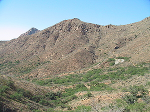
Gold? Silver? ...No chance. Amazing views? Oh yea!
by Jeffshadows

 
History
The Quantrell Mine is not unlike many other mines on the south side of the Santa Ritas. Places like Dunesque and Harshaw have stood the test of time and serve as reminders of what once drew men into these mountains. The Forest Service reports that Quantrell once produced large amounts of gold and silver in its better years. Today the only thing that sets it apart from the numerous other mines and prospects that litter the winding course that bears its name is its sheer size and the plurality of the works left on site. Quantrell boasts remains of loading works, three large tunnels, and a massive scree hill that can be seen on the Google satellite image of the area.


The Hike
The Quantrell Mine Trail begins at a junction with the Elephant Head Bike trail (FSR 930). The best way to reach the trail is to hike the first nine-tenths of a mile from Agua Caliente Canyon along Elephant Head. The trail here is well-worn and route finding is easy. The trail is rocky and typical of many desert hiking trails, offering little protection from the sun. The views to the east of Mt. Hopkins and its Multiple Mirror Telescope are excellent. The trail climbs to a saddle behind Little Elephant Head peak and offers awesome mini-forests of Santa Rita Prickly Pear. The climb is gradual and offers no major obstacles or step-ups. At the saddle, a small, stoned-off side trail breaks west to the summit of Little Elephant Head. From the saddle, Elephant Head drops sharply into Chino Canyon. The goings seem like a respite from the previous climb but provide for an exposed and fairly steep climb on your return trip. This section of the trail seems to be the most adversely affected by the mountain bike traffic, as most of the bedrock is slick and the ground is beaten and slippery in many places. At just about nine-tenths of a mile, the trail approaches a small bosque of mesquite and a trail marker sign. The Quantrell Mine trail climbs east (right) away and the Elephant Head Trail continues down the canyon. Turn right.
remove free decal offer
Now beyond the junction, you are on the actual Quantrell Mine trail. The trail winds its way up loose rock and reaches the first of several old mines after about a quarter of a mile. This initial section of the trail seems to see a lot of abuse by ATV traffic, and it makes the goings harder under loose and strewn rock and ruts in the trail. An OHV trail connects to Quantrell from Chino Canyon. Luckily, the trail beyond this first mine seems to only see use by bikes, equestrians, and hikers. The trail climbs away from the first mine and passes several more spectacular forests of Santa Rita Prickly Pear, before winding its way west and narrowing in places. It's easy to see how this was once a road traveled by motorized vehicles. Many of the minor canyons the trail encounters see it built up using crushed stone native to the area as support. In a couple of places, these supports are crumbling or gone completely. The hills have washed down and trees sprung up, leaving the trail impassible to vehicles as it winds its way around to the west and below an unnamed peak. This section of trail climbs gradually, but relentlessly.

Shortly after winding back east, Quantrell Mine is visible off on the hillside below the minor peak to the south that houses a few television and cell phone towers. This final stretch of trail is pleasant and easygoing. You now enter juniper and pinyon and finally feel like you're actually in the Santa Ritas. A few paces before the mine, a route marked by a large cairn breaks due west toward Elephant Head, and eventually achieves its summit. The trail approaches the mine and its large tailing piles after roughly four-tenths of a mile of following the ridge. The final section of the trail winds its way north and then turns southeast to climb atop the mine tailings. Amazing views of Chino Canyon and Elephant Head dominate. Care should be exercised around the mine and its tailings.

Return the way you came. One note about the return course: When approaching the junction with the Elephant Head Trail it is easy for one to become confused and begin down Chino Canyon. The Quantrell Mine trail approaches and seamlessly becomes the down-canyon section of Elephant Head, whereas the section of Elephant Head that climbs back to the saddle takes a sharp right and immediately climbs away.

2008-06-07 Jeffshadows


    Check out the Official Route and Triplogs.
    Leave No Trace and +Add a Triplog after your hike to support this local community.
    WARNING! Hiking and outdoor related sports can be dangerous. Be responsible and prepare for the trip. Study the area you are entering and plan accordingly. Dress for the current and unexpected weather changes. Take plenty of water. Never go alone. Make an itinerary with your plan(s), route(s), destination(s) and expected return time. Give your itinerary to trusted family and/or friends.

     Permit $$
    Visit overview & permits.
    2024 - FAQ
    $8 per vehicle per day
    $10 per vehicle per week
    $40 per vehicle per year (valid for one year from the date of purchase)

    There are four specific day-use areas that require a Coronado Recreational Pass or a National Pass/America the Beautiful Pass.
    1) Sabino Canyon - located on the Santa Catalina Ranger District (520)749-8700
    2) Madera Canyon - located on the Nogales Ranger District (520)281-2296
    3) Cave Creek - located on the Douglas Ranger District (520)364-3468
    4) Mt. Lemmon at 11 day-use sites.

    2022 Catalina State Park
    Per vehicle (1-4 Adults): $7.00
    Individual/bicycle: $3.00

    2022 Sabino Canyon Tram is $15 extra. [ website ]

    Coronado Forest
    MVUMs are rarely necessary to review unless mentioned in the description or directions
    Coronado Motor Vehicle Use Maps (MVUMs)


     Directions
    or
     Road
    FR / Jeep Road - Car possible when dry

    To Elephant Head (arbitrary/unofficial) Trailhead
    From anywhere in Tucson, head south to I-19. Take I-19 south to exit 56 (Canoa). Take the east Frontage road south for three miles to Elephant Head road. Follow Elephant Head for about one and a half miles and turn right onto Mount Hopkins road. Take Mt. Hopkins road for 5.5 miles and turn north onto FSR 183, which is marked by the standard vertical FS road marker. Follow FSR for about two and a half miles until it approaches the basin of Agua Caliente stream. A large sign to the right of the road states "Dead End 2 Miles." Park here under the plentiful trees. Walk back down FSR 183 in the direction you just came for about 100 meters until you encounter the junction with FSR 930 - The Elephant Head Trail.

    2015-12-20 philmacduff writes: High clearance vehicles recommended on FSR 183. The road becomes impassable to cars with less than 9" clearance (even when dry) approximately 200m from the trailhead. Up until this point, with careful driving, it is doable with a decent 2WD car. You should be able to find a spot to park on the side of the road somewhere prior to this point. Be prepared to back down the dirt road if needed. Also, note that FSR 183 is not marked well from Mt Hopkins Rd as FSR 183. There is a small sign about 40 yards down the dirt road, but nothing else was visible from Mt Hopkins Rd.

    2014-03-03 andrewbares writes: Another rougher 4x4 entrance exists, on FR 4073. Same as above, exit 56 from I-19 and turn left on Elephant Head Rd. However, continue on Elephant Head Road and simply keep straight (turns into Hawk Way). Eventually, it'll turn into a dirt road that heads southeast. Continue on that dirt road. You'll reach a gate on your left, but continue straight (goes directly south now). Finally, you'll reach another gate at the end of a big open parking area, and you'll go left through that gate. Very soon after, you'll come to a 4-way intersection... turn right onto FR 4073, which has a marker a little way down the turnoff. This is where the road starts getting rougher. You'll cross through the wash and continue heading south for the rest of the drive. Stock 3rd generation 4Runners (1996-2002) will be perfectly fine. No rear lockers are needed. I recommend 9.5" of ground clearance. Low gears aren't even needed. It's just a rocky trail. At the very end, it will get quite narrow (and eventually turns into an ATV trail) so park where you feel comfortable.

    From PHX (I-10 & AZ-51) - 2 hr 37 min (155 miles)
    From TUC (Jct 1-10 & Grant) - 58 min (45.4 miles)
    From FLG (Jct I-17 & I-40) - 4 hr 40 min (298 miles)
    (Trailhead is generic)
    page created by Jeffshadows on Jun 06 2008 10:33 pm
     90+° 8am - 6pm kills
    helpcorrectionissue

    end of page marker