Route Editor

| Guide | ♦ | 10 Triplogs | 0 Topics |
details | drive | no permit | forecast | 🔥 route |
stats |
photos | triplogs | topics | location |
| 63 | 10 | 0 |
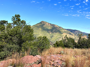
Catherine the Great by John10s   Overview OverviewMt. Catherine is located in the Mazatzal Wilderness between Mt. Peeley (~1.5 miles to the southeast) and Mazatzal Peak (~3 miles to the northeast). The summit is accessible with a round-trip hike of ~14 miles from Peeley Trailhead, with the majority of the miles on the well-maintained Mazatzal Divide Trail. Although there are several higher peaks on a ridge to the northeast (unnamed peaks 7532, 7549, and 7579), Mt. Catherine offers beautiful panoramic views of the surrounding area and many other Mazatzal summits. Hike From Peeley Trailhead, start on Cornucopia Trail #86 for roughly a half mile, then stay right at the signed intersection to continue on Mazatzal Divide Trail #23, which is typically well-maintained, as it's part of the Arizona Trail. About a mile in, you'll climb a series of long switchbacks as the Mazatzal Divide turns to the north, and after another two-thirds of a mile, the trail takes a sharp turn to the west, opening up views of Mt. Catherine and the unnamed peaks.
Roughly three miles in, Mazatzal Divide turns back to the north, heading directly toward Catherine. Along this stretch, the views eventually open up to the west to reveal some of the western Mazatzal peaks, including Table Mountain and Davenport Peak. Beyond the wilderness boundary, Horseshoe Reservoir and the peaks to its west are also visible. On this section of trail, you'll also enjoy views of the ridgeline to the south that includes Peeley, Peak 6910, and Sheep Mountain. Nearing the southeast side of Catherine, just short of five miles into the hike, you have the option to leave the trail and take a more direct route up to the peak along a steep, brushy ridge. The official route described here approaches from the north side along a gentler slope, but you can refer to the triplogs for details on the shortcut. To follow the official route, continue on Mazatzal Divide Trail as it circles around the east/northeast sides of the mountain, passing through a lot of fire-damaged trees. Choose the spot that looks easiest to leave the trail and start the final ascent to the peak. On the official route, that point is just short of 6.5 miles into the hike, at 34.0297489, -111.4961742. The approach isn't overly steep; after leaving the trail, you'll gain ~400' of elevation over a little more than a half mile. The official route provides a good reference, but brush will be the main factor that determines what route looks easiest. You may encounter some light scrambling depending on your chosen route, but the approach doesn't have any major obstacles. Mt. Catherine has a wide, flat top that offers largely unobstructed views. To the north/northeast, you can see Mazatzal Peak and the ridge with the three unnamed peaks, along with the Mogollon Rim beyond. To the southeast, Peeley Trailhead is visible below, along with Mt. Ord and Four Peaks. To the south are views of Saddle Mountain and the ridgeline from Peeley to Sheep Mountain. Both Bartlett Reservoir and Horseshoe Reservoir are also visible to the west/southwest of the summit. There are plenty of trees on top to find some shade and enjoy the summit. Depending on the time of year, you may encounter a large quantity of lady bugs that are common on many of the higher Mazatzal peaks. Before starting down, look for the register buried in the summit cairn. You can return to Peeley Trailhead using the same route or take the shortcut down the steeper, southeast side of the peak described in triplogs. Check out the Official Route and Triplogs. Leave No Trace and +Add a Triplog after your hike to support this local community. | ||||||||||||||||||||||||||||||||||||||||||||||||||||||||||||||||||||||||||||||||||||||||||||||||||||||||||||||||||||||||||||||||||||||||||||||||||||||||||||||||||||||||||||||||||||||||||||||