 Route Editor

| Guide | ♦ | 67 Triplogs | 0 Topics |
details | drive | no permit | forecast | 🔥 route |
stats |
photos | triplogs | topics | location |
| 595 | 67 | 0 |
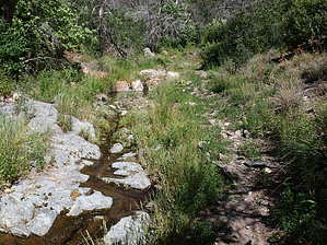
Descent into Mazzie Paradise by jacobemerick   Overview OverviewMany hikers will only use the northern end of Cornucopia Trail to hike from Peeley Trailhead to Mazatzal Divide #23, and then either summit Peeley or continue north along a scenic ridge hike. That's great, though they miss out on a scenic descent into a tributary of Sycamore Creek. Staying on Cornucopia could unlock the classic Cornucopia - Thicket Spring Loop or start a longer adventure on AZT #22. History The 2012 Sunflower Fire damaged much of this area. A few sweet spots were spared.
Mount Peeley trailhead is well signed and has parking for... several... vehicles. From here, head up Cornucopia Trail, which winds along fire-damaged hills for a quick 0.5 mile, 200' climb. The low vegetation and lack of shade will probably make this climb feel worse than it actually is. The junction w/ Mazatzal Divide Trail also marks the split of two Arizona Trail sections and is marked with the expected rusty sign. Turn left to follow Cornucopia. The trail now follows an old road and is quite rocky as it trundles downhill. The views are fantastic, with Four Peaks and Superstition Ridgeline marching to the south. At 1.5 miles, a few trees cast spotted shade near Thicket Spring, and then a busy trail sign marks the junction with Thicket Spring Trail. Turn left to continue downhill on Cornucopia. A few tall pines show up as the route plays high above a rocky canyon, though it never commits to dropping into it. Instead, it hops over a small saddle at 2.0 miles to find an alternate drainage to follow downhill. The path stays close to the bottom of this drainage, crossing a few times, and some trickling water can be found along the way. Some pleasant combinations of shade and water make for ideal resting spots. Eventually, the trail ends, and one needs to decide if they want to turn around and make the thousand-foot gain back to the trailhead, turn right to slog up West Fork Trail, or continue down along the creek towards FR 25 and forget about their parked car for a few more hours. Water Sources You might find water trickling in pools along the bottom of the creek from mile 2.0 to 3.0. Camping Thicket Spring had a flat spot and an old turn-around point uphill, though both would probably be dry much of the year. Check out the Official Route and Triplogs. Leave No Trace and +Add a Triplog after your hike to support this local community. One-Way Notice This hike is listed as One-Way. When hiking several trails on a single "hike", log it with a generic name that describes the hike. Then link the trails traveled, check out the example. | ||||||||||||||||||||||||||||||||||||||||||||||||||||||||||||||||||||||||||||||||||||||||||||||||||||||||||||||||||||||||||||||||||||||||||||||||||||||||||||||||||||||||||||||||||||||||||||||||||||||||||||||||||||


