Route Editor

| Guide | ♦ | 21 Triplogs | 0 Topics |
details | drive | permit | forecast | route |
stats |
photos | triplogs | topics | location |
| 129 | 21 | 0 |
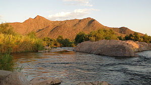
perfect for families with children by Charger55  Overview OverviewPhon D Sutton Recreation Area, off the Bush Highway west of Ellsworth, offers Valley residents one of the easiest opportunities to check out a riparian area in the Sonoran Desert. Lush vegetation is abundant. Wildlife is plentiful. And the boulders that rise out of the Salt River coupled with the stark beauty of Red Mountain in the background create a truly picturesque setting. With that said, it's also seen a lot of its beauty tarnished. Vandals have spray-painted graffiti on the boulders. Trash is everywhere. And the feral horses that call the Lower Salt River Valley home have left their evidence at every other step. Hiking here requires a think skin and an acceptance that this environment may not recover from the damage continually inflicted upon it. There is one established trail at the Rec Area; the Lower Salt River Nature Trail. It's a 2.3-mile loop that encompasses various desert ecosystems giving you a taste of scenery you won't see with other hikes this close to the metro area. Is it for the hardcore hiker? No, but it's perfect for families with children, birdwatchers, and people looking to rack up triplogs quickly. I fit into the latter two categories.
From the southwest corner of the parking lot, the trail takes off from behind the restrooms. You'll notice right away the trail is clearly marked with signposts. Many of these posts have been knocked over or are twisted to point the wrong way, but rest assured, you'll never end up too far off-trail. Just keep an eye out for the next post in the distance, and you'll do fine. After ducking in and out of a couple of drainages, you'll come to a trail junction at 0.2 miles. The natural tendency is to stick close to the river, so veer right. You'll come back the other way. Many spur trails will offer you a chance to explore the banks of the Salt. Views of Red Mountain are amazing! Enjoy them, as you can't legally get much closer. This is also the best area for birdwatching. Great Blue Herons are easily spotted wading just off-shore. The turkey vulture, a hearty scavenger, will take advantage of any left-behind garbage. Ducks and grebes can be spotted in the river, while hawks and falcons can be seen overhead. Gradually, you'll move away from the river. On this stretch, I came across some extensive burrows in the ground just off-trail. They were about one-foot in diameter. When I peered over the side, I heard the unmistakable sound of a rattlesnake. Taking a step back, I realized it wasn't coming from within the hole but above it. Perched in a tree, two feet off the ground, was a western-diamondback! I've never seen rattlesnakes exhibit arboreal tendencies before. Needless to say, every time I ducked under a tree branch, I was a little more cautious after that experience. As you distance yourself from the Rec Area, you'll notice the interpretive signs, missing earlier in the hike, will start to pop up again. You'll head through a section of Salt Cedar before coming to some giant cottonwoods at approximately 1 mile. From here, the trail contours east through a mesquite forest. The thick canopy can make this section downright spooky if you're hiking solo. The trail then turns north to head out of the mesquite forest at roughly 1.4 miles. Vegetation will thin, and soon you'll find yourself surrounded by typical Sonoran desert scenery; creosote, paloverde, and the stately saguaro cactus. Be on the lookout for Gambel's Quail. I startled a covey of at least fifty on this stretch of trail. At 2.1 miles, you'll complete the loop. The parking lot and restrooms are just a few minutes ahead. Check out the Official Route and Triplogs. Leave No Trace and +Add a Triplog after your hike to support this local community. | |||||||||||||||||||||||||||||||||||||||||||||||||||||||||||||||||||||||||||||||||||||||||||||||||||||||||||||||||||||||||||||||||||||||||||||||||||||||||||||||||||||||||||||||||||||||||||||