 Route Editor

| Guide | ♦ | 11 Triplogs | 0 Topics |
details | drive | no permit | forecast | route |
stats |
photos | triplogs | topics | location |
| 56 | 11 | 0 |
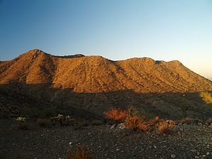
 Overview OverviewThe Casa Grande Mountain Trails MAP lists this hike at 4.60 miles and consequently the GPS track was mapped at 4.48 miles, including the overlook spur at about the four-mile mark (Fire - Four 3.4.11). The route terminates at the West Butte Trail. The return can be the same trail or a combination of the other trails within the park. Regardless of your return choice, it'll be at least nine miles roundtrip from Peart Road TH. The trail starts on the northern end at the Peart Road trailhead (though it can also be accessed from the Henness Road Trailhead) and follows the Casa Grande Mountains' foothills towards Arizona City.
This hike is long (for Casa Grande standards), hot, dry, and shadeless. There are plenty of cacti and reptiles. Use appropriate caution. History 2011, the trail was revamped by the City of Casa Grande. There was a bevy of informal use-trails across the area, but since the city has put effort into maintaining this trail, the informal trails have seen a decrease in their usage. Six Casa Grande city signs are waypointed on the official route. These represent each of the volunteer Americorps teams and the date(s) they were on one of the trails they helped build. Hike The East Ridgeline Trail is slightly misnamed as it does not follow a ridgeline. However, this is seemingly what the locals call it, so that is what I will call it here. If I find a more official name, I'll change it. The trail starts at the Peart Road trailhead. The trail branches off immediately to the east from the parking area and is very faint at the trailhead. Look for a boot-worn trail heading perpendicular to the parking lot, towards the small drainage in the middle ground. After passing by the drainage and the saguaro next to the trail, the ERT becomes much better defined and easier to follow. It loops around the low ridge near the parking area and then starts climbing up above the Heness Basin (dirt parking area and trailhead). The trail crosses the Heness/Peart closed road and climbs to a small saddle, where you get a good look at the next basin. This pattern repeats itself all along the eastern foothills of the Casa Grande Mountains. The trail stays above the valley floor and below the steepest parts of the actual Casa Grande Mountains as it winds its way between different drainage basins. The geology of this trail is much more mundane than the Ridgeline Trail, but the fauna is more diverse, as is the flora. There are a few gradual switchbacks as the trail climbs toward saddles or drops toward posted junctions. The trail is well-constructed and well-maintained by volunteers and the City of Casa Grande. You can turn around at any point you decide and make your way back to the Peart (or Henness) trailhead. Alternatively, you can continue down the trail to where it intersects either Arica Road, out of Eloy, or the southern Henness Road trailhead at the south end of the Casa Grande Mountains. This ~14-mile round trip is popular with mountain bikers but not as much with hikers. Still, with several trailhead options to increase or decrease the hike's length to your desire, good hiking and good times can be had along the ridgeless bajada ridge. Water Sources None, bring your own. Camping Not allowed. Synopsis The majority of this trail is listed as the most difficult in the park, but still tame (low AEG and good quality) when compared to many other routes in the nearby and similar mountains. This point illustrates the subjectivity of trail ratings. City of Peoria trails debuted with similar exaggerated couch potato ratings. 2024 HAZ_Hikebot, nobody's hero, merged Culture Jesus & Sporty Jesus interpretations.
Check out the Official Route and Triplogs. Leave No Trace and +Add a Triplog after your hike to support this local community. One-Way Notice This hike is listed as One-Way. When hiking several trails on a single "hike", log it with a generic name that describes the hike. Then link the trails traveled, check out the example. | |||||||||||||||||||||||||||||||||||||||||||||||||||||||||||||||||||||||||||||||||||||||||||


