Overview
At approximately 7900 feet, Mount Davis is the second-highest point in the Bradshaw Mountains, the first being nearby Mount Union, at 7979 feet. This hike uses Dandrea Trail #285 and Yankee Doodle Trail #284 forest trails along with an off-trail segment to bring you to the top of the peak. Trail #285 begins on the south side of the Potato Patch cabins area, where Poacher's Row road comes to an abrupt end on forest service land. If you don't have a high clearance vehicle, it might be wise to park along Walker Road or Poacher's Row road and walk from there to the trailhead. You can easily do this hike in conjunction with Mount Union.
Hike
At the trailhead where Poacher's Row road ends, two rough ATV trails climb up from the creek bottom into the forest. Please take the right fork, which is marked as trail #285, and follow it uphill. Almost immediately, trail #285 forks; stay left and continue uphill through the aspens. Around 0.2 miles, the trail forks again. Go right.
Tall fir trees and aspens fill the canyon of the usually dry Hassayampa River and keep the trail well shaded. You can see evidence of the area's rich mining history in the form of partially collapsed mine tunnels and overgrown tailings piles. Keep an eye out for the old arrastra (ore crushing pit) in the canyon bottom.
About a mile in the trail ascends a few switchbacks as it nears the top of the Hassayampa River canyon. The Prescott area comes into view briefly, just before trail #285 meets trail #284 in an open saddle at the 7600-foot level. Turn left and begin following trail #284 east.
After hiking about a tenth of a mile on trail #284, the forest on the left above the trail begins to open up a bit. Head uphill from this area to the crest of Mount Davis' south ridge. From its south ridge, the top of Mount Davis is easily reached in only about a third of a mile, with only a few minor rocky obstacles in an open forest of ponderosa pine and Gambel Oak.
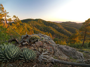
Mount Davis' summit is marked by a small cairn and register. The view from its summit of the surrounding mountains is wonderful. An even better and nearly unobstructed view from a small, rocky hilltop is about 0.1 miles past the summit.
The easiest way back down is likely the way you took to get up. Enjoy!
WARNING! Hiking and outdoor related sports can be dangerous. Be responsible and prepare for the trip. Study the area you are entering and plan accordingly. Dress for the current and unexpected weather changes. Take plenty of water. Never go alone. Make an itinerary with your plan(s), route(s), destination(s) and expected return time. Give your itinerary to trusted family and/or friends.
Only trailheads with six "amenities" have fees. Amenities are picnic tables, trash, toilet, parking, interpretive signing and security.
Directions
Road
FR / Jeep Road - Car possible when dry
To hike From the highway 69/highway 89 junction in Prescott, head east on highway 69 for 2.85 miles to the Walker Road stoplight. Turn south on Walker Road (a.k.a. county road 57, which later turns to dirt), and follow it for 10.5 miles to its junction with Poacher's Row road. Turn left and follow Poacher's Row road for 0.33 miles through the Potato Patch cabins area to its end on Prescott National Forest land. There is a brown fiberglass signpost for trail #285 next to a large tree.
page created by PrestonSands on Sep 20 2011 12:13 am
 Route Editor

 Overview