username
X
password
register
for free!
help


Cat Peaks Trail - Usery, AZ

Guide 58 Triplogs  0 Topics
  2.4 of 5  
Fav
Wish
0
details
drive
permit
forecast
route  
stats
photos
triplogs
topics
location
174 58 0
Statistics
tap row or icons for details
Difficulty 1 of 5
Distance One Way 1.1 miles
Trailhead Elevation 1,795 feet
Elevation Gain 136 feet
Accumulated Gain 136 feet
Avg Time One Way 0.5 hours
Kokopelli Seeds 1.55
feature photo
Photos Viewed All MineFollowing
Will recalculate on button tap!
7  2025-06-15
Blevins Trail
DarthStiller
8  2025-01-19
Pass Cats and peak
tibber
10  2025-01-19
Blevins Trail
DarthStiller
14  2023-12-17
Meridian Mystery Trail
DarthStiller
6  2023-01-17 Tortoise_Hiker
10  2022-11-29
Blevins Trail
Tortoise_Hiker
8  2022-11-06 wallyfrack
7  2021-11-03
Usery Park Smorgasbord
Daytripper
Page 1,  2,  3,  4
Author
author avatar Guides 16,843
Routes 17,472
Photos 24
Trips 1 map ( 6 miles )
Age 28 Male Gender
Location HAZ, TrailDEX
Co-Author
co-author avatarGuides 13
Routes 100
Photos 1,794
Trips 372 map (1,808 Miles)
Age 51 Male Gender
Location Mesa AZ
Associated Areas
list map done
Phoenix Region
Historical Weather
Trailhead Forecast
Radar Map
Expand Map
Preferred Jan, Feb, Dec, Nov
Sun  6:02am - 6:48pm
Official Route & 2 Rts
 
15 Alternative


remove free decal offer

 
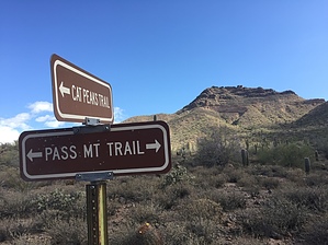
Cat Peaks trail is located within the confines of Usery Mountain park and can be reached from Blevins Trail in west or Meridian Trail from the east.


The trail has some nice elevation changes and provides great views of the Valley, the Superstition Wilderness, Goldfield Mountains, Pass Mountain and Usery Mountain.

2011-10-03 HAZ_Hikebot & BEEBEE
  • Usery Trails 2019 Map
    area related
    Usery Trails 2019 Map
  • Usery Trails 2019 Map
    area related
    Usery Trails 2019 Map


Check out the Official Route and Triplogs.
Leave No Trace and +Add a Triplog after your hike to support this local community.

One-Way Notice
This hike is listed as One-Way.

When hiking several trails on a single "hike", log it with a generic name that describes the hike. Then link the trails traveled, check out the example.
WARNING! Hiking and outdoor related sports can be dangerous. Be responsible and prepare for the trip. Study the area you are entering and plan accordingly. Dress for the current and unexpected weather changes. Take plenty of water. Never go alone. Make an itinerary with your plan(s), route(s), destination(s) and expected return time. Give your itinerary to trusted family and/or friends.

 Permit $$
Maricopa Regional Parks - 2024 [ fees ]

$7 per vehicle, $85 annual or trade your firstborn for the life pass

$2 walk, bike, or horse ride into the park

2024 [ hours ] - varies by park & season


 Directions
or
 Road
Connector trail - Not Applicable

To hike
The trail is within the confines of the park and can be reached from several different connector trails.
page created by BEEBEE on Oct 03 2011 12:09 pm
 90+° 8am - 6pm kills
helpcorrectionissue

end of page marker