 Route Editor

| Guide | ♦ | 37 Triplogs | 0 Topics |
details | drive | permit | forecast | route |
stats |
photos | triplogs | topics | location |
| 18 | 37 | 0 |
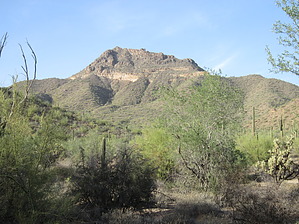
Short but sweet by BEEBEE  Overview OverviewThis 0.3-mile trail is located in Usery Mountain Park between the 2 peaks of Cat Peaks. You can access the trail from Cat Peaks Trail on the East end and the Blevins Trail on the west end. The trail itself is short by can be incorporated into other trails in the park to make for some nice loops. Hike Signs mark both ends of the trail. A short climb through the pass provides excellent 360-degree views. At the top of the pass, you can move between the 2 peaks to get a better vantage point of the valley. The elevation makes for some nice picture-taking opportunities, and overall the hike is light and would be good for out of town visitors who would like to see some of the desert.
Check out the Official Route and Triplogs. Leave No Trace and +Add a Triplog after your hike to support this local community. One-Way Notice This hike is listed as One-Way. When hiking several trails on a single "hike", log it with a generic name that describes the hike. Then link the trails traveled, check out the example. | |||||||||||||||||||||||||||||||||||||||||||||||||||||||||||||||||||||||||||||||||||||||||||||||||||||||||||||||||||||||||||||||||||||||||||||||||||||||||||||||||||||||||||||||||||||||||||


