Route Editor

| Guide | ♦ | 5 Triplogs | 0 Topics |
details | drive | permit | forecast | map |
stats |
photos | triplogs | topics | location |
| 11 | 5 | 0 |
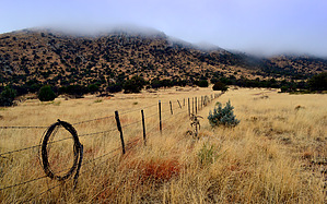
  Overview OverviewThis trail (#665 4x4 forest Rd.) steadily climbs for the first 1.5 miles to its high point at 6051 ft before dropping down into a hidden valley for the last 1.5 miles ending at a boundary gate in an area known as Bark Trick Tank. This mountain range is known locally as the Greasewoods and has many scenic views of the southern Pinaleno mountains along with a lovely meadow at the trail's end. Gate Policy: If a gate is closed upon arrival, leave it closed after you go through. If it is open, leave it open. Leaving a closed gate open may put cattle in danger. Closing an open gate may cut them off from water. Please be respectful, leave gates as found. The exception is signage on the gate directing you otherwise. Check out the Triplogs. Leave No Trace and +Add a Triplog after your hike to support this local community. | ||||||||||||||||||||||||||||||||||||||||||||||||||||||||||||||||||||||||||