tap row or icons for details
Popular
Workout
Difficulty
3 of 5
Route Finding
2 of 5
Distance One Way
3.15 miles
Trailhead Elevation
1,241 feet
Elevation Gain
1,099 feet
Accumulated Gain
1,320 feet
Kokopelli Seeds
7.55
list
map
done
Phoenix Region
Historical Weather
Trailhead Forecast Radar Map
Preferred Feb, Dec, Mar, Nov
Named Locations Coordinate Links
Pyramid Trail - South Mountain
Official Route HAZ_Hikebot
3.04 mi
Pyramid Trail - South Mountain
7.51 mi
Pyramid Trail - South Mountain
6.25 mi
Pyramid Trail - South Mountain
5.5 mi
Pyramid Trail - South Mountain
3.38 mi
Pyramid Trail - South Mountain
8.02 mi
Pyramid Trail - South Mountain
4.63 mi
Pyramid Trail - South Mountain
6.24 mi
Pyramid Trail - South Mountain
4.36 mi
Pyramid Trail - South Mountain
6.2 mi
Pyramid Trail - South Mountain
6.27 mi
Pyramid Trail - South Mountain
4.42 mi
Pyramid Trail - South Mountain
6.82 mi
Pyramid Trail - South Mountain
6.2 mi
Pyramid Trail - South Mountain
6.01 mi
Pyramid Trail - South Mountain
5.45 mi
Pyramid Trail - South Mountain
7.7 mi
Pyramid Trail - South Mountain
4.18 mi
Pyramid Trail - South Mountain
13.26 mi
Pyramid Trail - South Mountain
4.23 mi
Pyramid Trail - South Mountain
2.28 mi
Pyramid Trail - South Mountain
6.63 mi
Pyramid Trail - South Mountain
3.62 mi
Pyramid Trail - South Mountain
5.51 mi
Pyramid Trail - South Mountain
4.27 mi
Pyramid Trail - South Mountain
6.66 mi
Pyramid Trail - South Mountain
10.19 mi
Pyramid Trail - South Mountain
2.59 mi
Pyramid Trail - South Mountain
10.79 mi
Pyramid Trail - South Mountain
10.8 mi
Pyramid Trail - South Mountain
4.21 mi
Pyramid Trail - South Mountain
10.09 mi
Pyramid Trail - South Mountain
4.41 mi
Pyramid Trail - South Mountain
4.53 mi
Pyramid Trail - South Mountain
4.47 mi
Pyramid Trail - South Mountain
5.48 mi
Pyramid Trail - South Mountain
5.05 mi
Pyramid Trail - South Mountain
5.52 mi
Pyramid Trail - South Mountain
5.47 mi
Pyramid Trail - South Mountain
4.96 mi
Pyramid Trail - South Mountain
5.54 mi
Pyramid Trail - South Mountain
5.48 mi
Pyramid Trail - South Mountain
4.19 mi
Pyramid Trail - South Mountain
6.22 mi
Pyramid Trail - South Mountain
4.45 mi
Pyramid Trail - South Mountain
8.2 mi
Pyramid Trail - South Mountain
6.25 mi
Pyramid Trail - South Mountain
4.82 mi
Pyramid Trail - South Mountain
4.39 mi
Pyramid Trail - South Mountain
4.72 mi
Pyramid Trail - South Mountain
6.35 mi
Pyramid Trail - South Mountain
4.46 mi
Pyramid Trail - South Mountain
6.66 mi
Pyramid Trail - South Mountain
4.33 mi
Pyramid Trail - South Mountain
4.37 mi
Pyramid Trail - South Mountain
6.52 mi
Pyramid Trail - South Mountain
10.66 mi
Pyramid Trail - South Mountain
4.44 mi
Pyramid Trail - South Mountain
5.64 mi
Pyramid Trail - South Mountain
5.53 mi
Pyramid Trail - South Mountain
6.48 mi
Pyramid Trail - South Mountain
4.54 mi
Pyramid Trail - South Mountain
5.6 mi
Pyramid Trail - South Mountain
5.55 mi
Pyramid Trail - South Mountain
5.39 mi
Pyramid Trail - South Mountain
6.01 mi
Pyramid Trail - South Mountain
4.29 mi
Pyramid Trail - South Mountain
4.33 mi
Pyramid Trail - South Mountain
3.12 mi
Pyramid Trail - South Mountain
5.66 mi
Pyramid Trail - South Mountain
6.6 mi
Pyramid Trail - South Mountain
6.2 mi
Pyramid Trail - South Mountain
6.03 mi
Pyramid Trail - South Mountain
6.07 mi
Pyramid Trail - South Mountain
6.03 mi
Pyramid Trail - South Mountain
6.76 mi
Pyramid Trail - South Mountain
5.52 mi
Pyramid Trail - South Mountain
5.47 mi
Pyramid Trail - South Mountain
5.46 mi
Pyramid Trail - South Mountain
4.28 mi
Pyramid Trail - South Mountain
6.59 mi
Pyramid Trail - South Mountain
6.56 mi
Pyramid Trail - South Mountain
5.46 mi
Pyramid Trail - South Mountain
6.62 mi
Pyramid Trail - South Mountain
5.54 mi
Pyramid Trail - South Mountain
5.51 mi
Pyramid Trail - South Mountain
5.52 mi
Pyramid Trail - South Mountain
5.52 mi
Pyramid Trail - South Mountain
5.46 mi
Pyramid Trail - South Mountain
5.51 mi
Pyramid Trail - South Mountain
4.73 mi
Pyramid Trail - South Mountain
5.45 mi
Pyramid Trail - South Mountain
5.49 mi
Pyramid Trail - South Mountain
5.37 mi
Pyramid Trail - South Mountain
5.6 mi
Pyramid Trail - South Mountain
5.65 mi
Pyramid Trail - South Mountain
6.89 mi
Pyramid Trail - South Mountain
6.8 mi
Pyramid Trail - South Mountain
4.54 mi
Pyramid Trail - South Mountain
4.34 mi
Pyramid Trail - South Mountain
6.72 mi
Pyramid Trail - South Mountain
5.66 mi
Pyramid Trail - South Mountain
5.44 mi
Pyramid Trail - South Mountain
5.4 mi
Pyramid Trail - South Mountain
5.48 mi
Pyramid Trail - South Mountain
4.23 mi
Pyramid Trail - South Mountain
4.17 mi
Pyramid Trail - South Mountain
4.2 mi
Pyramid Trail - South Mountain
4.3 mi
Pyramid Trail - South Mountain
2018-03-11
Frostshocknoob
6.49 mi
Pyramid Trail - South Mountain
4.31 mi
Pyramid Trail - South Mountain
4.26 mi
Pyramid Trail - South Mountain
5.96 mi
Pyramid Trail - South Mountain
4.77 mi
Pyramid Trail - South Mountain
5.93 mi
Pyramid Trail - South Mountain
6.22 mi
Pyramid Trail - South Mountain
4.22 mi
Pyramid Trail - South Mountain
6.09 mi
Pyramid Trail - South Mountain
5.96 mi
Pyramid Trail - South Mountain
6.8 mi
Pyramid Trail - South Mountain
6.61 mi
Pyramid Trail - South Mountain
4.3 mi
Pyramid Trail - South Mountain
9.25 mi
Pyramid Trail - South Mountain
9.06 mi
Pyramid Trail - South Mountain
7.59 mi
Pyramid Trail - South Mountain
4.6 mi
Pyramid Trail - South Mountain
4.1 mi
Pyramid Trail - South Mountain
4.64 mi
Pyramid Trail - South Mountain
6.58 mi
Pyramid Trail - South Mountain
4.23 mi
Pyramid Trail - South Mountain
4.23 mi
Pyramid Trail - South Mountain
4.23 mi
Pyramid Trail - South Mountain
4.35 mi
Pyramid Trail - South Mountain
4.22 mi
Pyramid Trail - South Mountain
4.23 mi
Pyramid Trail - South Mountain
4.28 mi
Pyramid Trail - South Mountain
4.35 mi
Pyramid Trail - South Mountain
2016-04-03
Frostshocknoob
7.02 mi
Pyramid Trail - South Mountain
8.84 mi
Pyramid Trail - South Mountain
8.88 mi
Pyramid Trail - South Mountain
8.89 mi
Pyramid Trail - South Mountain
8.88 mi
Pyramid Trail - South Mountain
6.6 mi
Pyramid Trail - South Mountain
6.62 mi
Pyramid Trail - South Mountain
6 mi
Pyramid Trail - South Mountain
6.02 mi
Pyramid Trail - South Mountain
7.57 mi
Pyramid Trail - South Mountain
4.22 mi
Pyramid Trail - South Mountain
7.12 mi
Pyramid Trail - South Mountain
6 mi
Pyramid Trail - South Mountain
6.5 mi
Pyramid Trail - South Mountain
6.41 mi
Pyramid Trail - South Mountain
3.22 mi
Pyramid Trail - South Mountain
5.39 mi
Pyramid Trail - South Mountain
6.42 mi
Pyramid Trail - South Mountain
6.98 mi
Pyramid Trail - South Mountain
2.95 mi
Pyramid Trail - South Mountain
5.93 mi
Pyramid Trail - South Mountain
3.2 mi
Gila Gila
11.7 mi
Telegraph - Prospector Lasso Loop
9.13 mi
Telegraph - Prospector Lasso Loop
9.37 mi
Telegraph - Prospector Lasso Loop
9.3 mi
National Trail - South Mountain
15.55 mi
Lost - Gila loop
7.37 mi
Lost - Gila loop
7.91 mi
Goat Hill Loop via Pyramid / Bursera
10.78 mi
Lost - Gila loop
7.76 mi
Gila - Lost loop
11.64 mi
Pyramid Lost Loop
8.03 mi
Lost - Gila loop
8.24 mi
Lost - Gila loop
7.65 mi
Lost - Gila loop
7.65 mi
Telegraph - Prospector Lasso Loop
9.36 mi
Telegraph - Prospector Lasso Loop
9.26 mi
Telegraph - Bursera Holbert Lasso...
20.28 mi
Gila Trail - South Mountain
5.07 mi
Telegraph - Bursera Short Lasso Loop
11.52 mi
Telegraph - Prospector Lasso Loop
9.2 mi
Prospector - Holbert Loop
15.16 mi
Prospector - Holbert Loop
15.55 mi
Telegraph - Prospector Lasso Loop
9.16 mi
Telegraph - Prospector Lasso Loop
9.26 mi
Telegraph - Prospector Lasso Loop
9.27 mi
Telegraph - Bursera Canyon Lasso ...
8.11 mi
Telegraph - Prospector Lasso Loop
9.28 mi
Pyramid Ruins
8.25 mi
Pyramid Loop
10.85 mi
Gila Gila
11.67 mi
Gila Trail - South Mountain
5.55 mi
Gila Trail - South Mountain
5.72 mi
Gila - Lost loop
7.69 mi
South Mountain west Loop
20.65 mi
Lost - Gila loop
7.9 mi
Ruins National Pyramid
8.34 mi
Ruins National Pyramid
8.45 mi
Las Lomitas Loop
10.88 mi
Goat Hill Loop via Pyramid / Bursera
11.51 mi
Lost - Gila loop
7.49 mi
Las Lomitas Loop
10.97 mi
Bursera - Bajada - Gila loop
12.56 mi
Pyramid Loop
11.35 mi
Lost - Gila loop
7.66 mi
Lost - Gila loop
7.27 mi
Gila - National Loop
11.78 mi
Gila - National loop
11.7 mi
Gila - National loop
11.87 mi
Goat Hill Loop via Pyramid / Bursera
12.34 mi
SoMo West Loop
10.98 mi
Goat Hill Loop via Pyramid / Bursera
10.68 mi
Lost - Gila loop
7.66 mi
Pyramid Loop
10.72 mi
Pyramid to Goat Hill
8.34 mi
Pyramid Loop
9.83 mi
Pyramid to Goat Hill
9.78 mi
Goat Hill Loop via Pyramid / Bursera
11.07 mi
Goat Hill Loop via Pyramid / Bursera
10.61 mi
Goat Hill Loop via Pyramid / Bursera
10.61 mi
Somo West Loop
10.74 mi
Gila - Lost loop
7.54 mi
Goat Hill via Lost - Gila loop
8.29 mi
Pyramid Loop
9.91 mi
Pyramid to Goat Hill
9.55 mi
Lost - Gila loop
11.09 mi
Lost - Gila loop
7.64 mi
Lost-Pyramid loop
7.71 mi
Pyramid-Lost loop
7.63 mi
Pyramid-Lost Loop
7.96 mi
Pyramid Loop
9.59 mi
Goat Hill Loop via Pyramid / Bursera
10.64 mi
Goat Hill Loop via Pyramid / Bursera
10.69 mi
Pyramid-Lost loop
7.77 mi
Pyramid-Lost Loop
7.64 mi
South Mountain 620 Trail Loop
9.34 mi
Pyramid Loop
9.81 mi
Pyramid Loop
10.73 mi
Lost Ranch National Pyramid
8.59 mi
Lost Ranch
2.89 mi
SW Tukee Foothills
10.54 mi
Pyramid Loop
7.5 mi
Gila-Lost loop
7.59 mi
Pyramid Loop
7.59 mi
Pyramid to Goat Hill
8 mi
Pyramid Loop
7.18 mi
Prospector Loop - South Mountain
4.09 mi
Goat Hill Loop via Pyramid / Bursera
13.31 mi
Goat Hill via National West
16.23 mi
Lost Camp Loop
4.9 mi
Goat Hill Loop via Pyramid / Bursera
10.79 mi
Goat Hill Loop via Pyramid / Bursera
10.55 mi
Pyramid-Lost loop
10.3 mi
Goat Hill Loop via Pyramid / Bursera
10.61 mi
SoMo Infinity Loop
32.85 mi
Lost-Pyramid loop
7.48 mi
Lost-Pyramid loop
7.33 mi
Lost-Pyramid loop
7.35 mi
Bursera Loop and Canyon
5.59 mi
Pyramid Lost Loop
10.27 mi
Lost-Pyramid loop
7.23 mi
Bursera Gila Loop
5.97 mi
Lost-Pyramid loop
8.2 mi
Lost-Pyramid loop
7.65 mi
SoMo Cicada Swelter
5.24 mi
Lost-Pyramid loop
7.12 mi
Lost Ranch Mine and Ruins Loop
5.43 mi
Lost-Pyramid loop
7.32 mi
Ranger Trail - South Mountain
10.28 mi
Goat Hill Loop via Pyramid / Bursera
10.29 mi
Lost-Pyramid loop
7.09 mi
Lost-Pyramid loop
7.59 mi
Eliminator to Goat Hill
6.18 mi
Lost-Pyramid loop
7.32 mi
National Trail - South Mountain
16.06 mi
Lost-Pyramid loop
8.25 mi
Lost-Pyramid loop
7.32 mi
Bees Knees Loop
7.62 mi
Goat Hill Loop via Pyramid / Bursera
10.78 mi
Goat Hill Loop via Pyramid / Bursera
11.69 mi
Goat Hill Loop via Pyramid / Bursera
10.37 mi
Lost-Pyramid loop
8.65 mi
Goat Hill Loop via Pyramid / Bursera
13.98 mi
SoMo Freestyle
4.54 mi
Pyramid loop
7.23 mi
SoMo Freestyle
6.5 mi
Goat Hill Loop via Pyramid / Bursera
11.03 mi
Pyramid-Lost loop
7.37 mi
Pyramid-Lost loop
8.22 mi
SoMo Freestyle
14.46 mi
Goat Hill Loop via Pyramid / Bursera
10.55 mi
Lost Ranch Mine Trail
7.71 mi
Pyramid Loop
7.64 mi
Pyramid Loop
7.54 mi
Lost Pyramid Loop
7.57 mi
Lost Ranch Ruins Trail
7.73 mi
Lost-Pyramid loop
7.8 mi
Goat Hill Loop via Pyramid / Bursera
10.52 mi
Pyramid Loop
7.52 mi
Goat Hill Loop via Pyramid / Bursera
10.54 mi
Telegraph Pass to Pyramid
5.14 mi
Pyramid loop
7.34 mi
Pyramid loop
7.08 mi
Pyramid - Lost loop
7.54 mi
Pyramid-Natl-Lost Mine lp
7.04 mi
Lost Ranch Mine-National-Pyramid ...
7.26 mi
Lost Ranch Mine -National-Pyramid
7.51 mi
Lost Mine-National-Pyramid loop
7.32 mi
Busera-Gila-Cholla Flat
8.12 mi
Pyramid-Natl-Lost Mine lp
7.31 mi
Pyramid-Natl-Lost Mine lp
7.32 mi
Pyramid-Natl-Lost Mine lp
7.33 mi
Goat Hill Loop via Pyramid / Bursera
11.1 mi
Ruins-National-Pyramid loop
8.23 mi
Goat Hill Loop via Pyramid / Bursera
12 mi
Lost Mine-National-Pyramid loop
7.25 mi
Goat Hill Loop via Pyramid / Bursera
8.72 mi
Pyramid-National-Bursera
11.07 mi
Goat Hill Loop via Pyramid / Bursera
10.55 mi
Goat Hill Loop via Pyramid / Burs...
10.86 mi
Bursersa-National-Pyramid Loop
11.38 mi
Pyramid-National-Lost Mine loop
7.32 mi
Pyramid-National-Lost Mine loop
7.38 mi
Cholla Flats - Pyramid
5.94 mi
Pyramid-National-Lost Ranch Mine ...
7.58 mi
Pyramid-National-Lost Mine loop
7.42 mi
Cholla Flats Loop
2.64 mi
Cholla Flats Loop
6.06 mi
Lost Mine-National-Pyramid loop
7.75 mi
Lost Mine-National-Goat-Pyramid Loop
7.42 mi
Lost Mine-National-Pyramid loop
7.33 mi
Lost Mine-National-Pyramid loop
7.3 mi
Goat Hill Loop via Pyramid / Bursera
13.08 mi
Lost Ranch Mine-National-Pyramid ...
7.52 mi
Goat Hill Loop via Pyramid / Bursera
10.85 mi
Lost Ranch Mine-National-Pyramid lp
7.45 mi
Lost Mine-National-Pyramid lp
7.37 mi
Goat Hill Loop via Pyramid / Bursera
10.74 mi
Goat Hill Loop via Pyramid / Bursera
13.38 mi
Telegraph to Lost Mine loop
9.17 mi
Ruins-National-Pyramid loop
8.94 mi
Pyramid Trail - South Mountain
4.34 mi
Goat Hill Loop via Pyramid / Bursera
10.52 mi
Lost Ranch Mine-National-Pyramid lp
7.28 mi
Ruins-National-Pyramid loop
8.3 mi
Ruins-National-Pyramid loop
8.27 mi
Lost Ranch Mine-National-Pyramid ...
7.53 mi
Lost Mine-National-Pyramid loop
7.47 mi
Lost Ranch Mine - Holbert Loop
16.54 mi
Bursera-Connector to National-Pyr...
8.42 mi
Pyramid to old lookout above Kiwanis
9.44 mi
Bursera Trail - South Mountain
10.33 mi
Bursera-National-Pyramid loop
10.5 mi
Bursera - National - Pyramid
10.43 mi
Bursera - Gila - National - Pyram...
10.83 mi
Pyramid to Goat Hill
7.93 mi
Lost Mine-National-Pyramid Loop
8.33 mi
Bursera - Gila - National - Pyram...
11.75 mi
Super SoMo
41.71 mi
Lost Mine - National - Pyramid loop
7.61 mi
Bursera-National-Pyramid loop
10.37 mi
Maricopa Peak via Pyramid Trailhead
14.97 mi
Gila-National-Lost Ranch SOMO Loop
11.56 mi
Kiwanis Trail - South Mountain
3.22 mi
Pyramid to Lost Ranch Ruins Loop
7.96 mi
Goat Hill Loop via Pyramid / Bursera
10.15 mi
Goat Hill Loop via Pyramid / Bursera
10.62 mi
Lost Mine-Natl-Pyramid loop
7.26 mi
Goat Hill Loop via Pyramid / Bursera
10.46 mi
Lost Ranch-National-Pyramid loop
8.49 mi
Bursera-National-Pyramid loop
10.46 mi
Bursera-National-Pyramid loop
10.42 mi
Pyramid Wash
4.18 mi
Lost Mine-Natl-Pyramid loop
7.19 mi
Lost Ranch-National-Pyramid loop
9.05 mi
Pyramid to National to Pima Canyon
12.48 mi
Pyramid Goat Ranger Las Lomitas K...
11.5 mi
Pyramid-Alta-Bursera loop
16.57 mi
Lost Mine-Natl-Pyramid loop
7.21 mi
Bursera-Gila-National-Pyramid loop
11.23 mi
Lost Ranch Mine-National-Pyramid ...
7.31 mi
Pyramid National GH Lost Ranch Ruins
7.88 mi
Bursera-Gila-National-Pyramid loop
11.53 mi
Pyramid National Bursera Loop
10.2 mi
Lost Mine-Natl-Pyramid loop
7.2 mi
Pyramid to Goat Hill
8.81 mi
Pyramid to Goat Hill
8.6 mi
Bursera-National-Pyramid loop
10.37 mi
Pyramid-National-Bursera loop
10.17 mi
Lost Ranch-National-Pyramid loop
8.47 mi
Bursera-Gila-National-Pyramid loop
11.02 mi
Pyramid Trail-Lost Mine Loop
6.75 mi
Lost Mine-Natl-Pyramid loop
7.29 mi
Lost Ranch-National-Pyramid loop
8.86 mi
Bursera-National-Pyramid loop
10.1 mi
Lost Mine-National-Pyramid loop
7.13 mi
Lost Mine-National-Pyramid loop
7.8 mi
Lost Ranch-National-Pyramid loop
8.29 mi
Lost Mine-National-Pyramid loop
7.24 mi
Lost Mine-National-Pyramid loop
7.65 mi
Pyramid to Goat Hill
8.95 mi
Lost Mine (east)-National-Pyramid...
7.37 mi
Pyramid Trail - South Mountain
7.59 mi
Lost Ranch Mine Trail
7.6 mi
Lost Ranch-National-Pyramid loop
8.92 mi
Pyramid to Goat Hill
9.53 mi
Lost Ranch-National-Pyramid loop
9.02 mi
Pyramid to Goat Hill
9.39 mi
Bursera-Gila-National-Pyramid loop
11.46 mi
Pyramid Partial
4.88 mi
Lost Ranch-National-Pyramid loop
7.97 mi
Pyramid Trail to Telegraph Pass T...
9.34 mi
Gila-National-Pyramid loop
10.58 mi
Lost Ranch-National-Pyramid loop
8.07 mi
Pyramid to Goat Hill
8.85 mi
Goat Hill via Ranger Trail
9.46 mi
Pyramid-National-Gila South Mountain
10.41 mi
Bursera Trail - South Mountain
11.14 mi
Goat Hill via Pyramid Trail
8.59 mi
Goat Hill via Pyramid Trail
8.56 mi
Goat Hill via Pyramid Trail
8.62 mi
Pyramid Trail to Goat Hill
8.62 mi
Pyramid National Bursera Loop
10.14 mi
South Mountain Mine Trails
4.31 mi
Bursera-National-Pyramid Trl loop
10.13 mi
Goat Hill via Pyramid Trail
8.71 mi
Pyramid Trail to Goat Hill
8.66 mi
Pyramid Bursera National Loop via...
11.74 mi
Bursera-National-Pyramid loop
9.98 mi
Bursera - National - Goat Hill - ...
10.15 mi
Pyramid National Bursera Loop
10.18 mi
Lost Ranch Ruins Trail
7.98 mi
Pyramid National Bursera
10.29 mi
Pyramid Loop
7.96 mi
Pyramid National Lost Ranch Ruins...
8 mi
Pyramid National Lost Ruins Loop
7.97 mi
Bursera Trail from Chandler TH
3.42 mi
Pyramid National Bursera Loop
10.7 mi
Bursera Trail - South Mountain
5.72 mi
Bees Knees Loop
7.35 mi
Ruins National Pyramid Loop
8.47 mi
Pyramid - National - Corona
9.52 mi
Overview
Pyramid Trail's southwest portion was constructed in early 2010. The remainder appears on South Mountain maps dating from 1942 and 1964. The City of Phoenix contracted the construction of the new part of the trail, from the viewpoint down into Ahwatukee, as part of the "area 620 land acquisition". As of July 2013, most of the 620 area trails remain unmarked. Only the Pyramid and Bursera trails are marked, so it pays to have a map or GPS while hiking here for the first time.
Access
The trailhead is located at Chandler Blvd and 19th Ave. If traveling on the Loop 202 Freeway, take the
17th Ave exit . Drive north to Chandler Blvd, then west to 19th Ave. There are parking spaces for about 30 vehicles. Additional parking is available along Chandler Blvd east of the trailhead.
Hike
Once on the trail, hike to the north and east as the trail bends around the near ridge. After hiking a few minutes, the trail splits at a brown 4X4 post. Stay to the right. The left fork is the beginning of the
Bursera Trail . Another small trail comes in from a trailhead on the right. Keep going straight. The now wide trail slowly bends to the north, and shortly you will reach an intersection with an east/west old mining road/trail. Turn right (east). You will then pass through two washes over the next half mile or so. The trail splits again just after coming out of two washes.
Bear left NE towards the now clearly seen switchbacks heading up to the Gila viewpoint. Soon the trail gets steep as you start up the ridge. After considerable climbing, you will reach the viewpoint atop the ridgeline. There are good views in all directions. To the north, you can see
Goat Hill ♡ above the
National trail as it stretches west. From the viewpoint the
Pyramid Trail follows the ridgeline east then north towards the National trail. After a bit, the trail splits and about a quarter-mile later rejoins itself. The left fork is a new section of trail that skirts the ridgeline. The right fork follows the ridgeline up and is a little longer, but it's my preferred route. Both forks offer excellent though very different views. The trail continues east before turning to the north where it ends at the intersection with the National trail at post #33. Post #33 is not far above the stone hut when hiking west on the National trail from
Telegraph Pass . Return the way you came.
Many other hiking options that include the
Pyramid Trail are available. The trail can easily be accessed from the Telegraph Pass or Kiwanis
trailheads along with two other 620 trailheads. Also, many loops in this area of South Mountain can be hiked that include the
Pyramid Trail and National trails.
One-Way Notice This hike is listed as One-Way.
When hiking several trails on a single "hike", log it with a generic name that describes the hike. Then link the trails traveled, check out the
example .
 Route Editor

 Overview
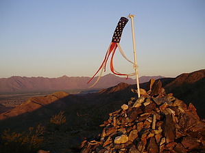


