| Guide | ♦ | 149 Triplogs | 0 Topics |
details | drive | permit | forecast | 🔥 route |
stats |
photos | triplogs | topics | location |
| 671 | 149 | 0 |
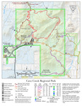
Go John By-Pass by MEWhiteman  Overview OverviewThis is a new trail (as of December 2011) in the southern part of the Cave Creek Recreation Area. It can be used to create a short loop or to extend the Go John Trail loop for a longer hike. The views are nice and provide a pleasant change from those on this section of the Go John. Hike I did this hike as an extension of the Go John Trail, which I hiked in the clockwise direction. At 4.60 miles N33 50.247 W111 59.176 on the Go John, the new Quartz Trail goes left at a signed junction. The trail is well-graded and easy to follow. It descends for a short distance then climbs gradually for about 1/4 miles. Then it descends, gradually losing 300 feet while following the contours around the hills in the southern part of the park. The trail is 1.35 miles long and ends at the Slate Trail at N33 49.619 W111 59.290. Turn right onto the Slate Trail. From here, you can follow the Slate Trail to its terminus south of the Go John trailhead or turn right on the Jasper Trail, which will bring you back to the Go John, where turning left will bring you back to the trailhead. This was a total of 7.0 miles, adding about 1.2 miles to the Go John loop.
Check out the Official Route and Triplogs. Leave No Trace and +Add a Triplog after your hike to support this local community. One-Way Notice This hike is listed as One-Way. When hiking several trails on a single "hike", log it with a generic name that describes the hike. Then link the trails traveled, check out the example. | |||||||||||||||||||||||||||||||||||||||||||||||||||||||||||||||||||||||||||||||||||||||||||||||||||||||||||||||||||||||||||||||||||||||||||||||||
 Route Editor


