Route Editor

| Guide | ♦ | 467 Triplogs | 1 Topic |
details | drive | permit | forecast | 🔥 route |
stats |
photos | triplogs | topic | location |
| 1.7k | 467 | 1 |
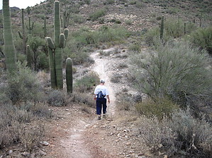
easy day hike by ck_1  The Go John Trail made Sweat Magazine's best hike list in last year's reader's poll. That proclamation made me want to check it out. If you're reading this, you are interested also. Coming from the East Valley, this was quite a haul for a short hike. The Cave Creek Recreation Area is located off the Carefree Highway north of Phoenix. The Go John Trail made Sweat Magazine's best hike list in last year's reader's poll. That proclamation made me want to check it out. If you're reading this, you are interested also. Coming from the East Valley, this was quite a haul for a short hike. The Cave Creek Recreation Area is located off the Carefree Highway north of Phoenix.As you reached the trailhead parking lot, you can't help but notice the wide trail headed virtually straight up to a pass. This is the trail. Starting from the Trailhead sign at an elevation of 2,120 feet, head north. More appropriately, head up. The trail is an old jeep road that is quite eroded. It doesn't switchback. It just heads up for about 3/4 of a mile until you come upon the pass. At an elevation of 2,470 feet, the views into Tonto National Forest are beautiful. Catch your breath. Carefully check out the abandoned mine shaft to your left. Continuing north, you descend at almost the same degree as you ascended. The trail is a steep downhill for about a quarter-mile. About this time you will encounter a junction with the Overton Trail. It is signed. From this point until the mile and a half mark you will cross and follow a series of washes. The trail is easy to follow.
For the next section of the trail, you'll be hiking along the side of the hill. When I did this hike, it must have been horse day, for we encountered more than a few riders heading in both directions. The remaining half-mile is hilly, with several short rises. You will be able to see the picnic area. Just past the four and a half mile mark, the heads right although the jeep road heads left and south. At 4.88 miles you return to the trailhead parking lot. My hike took 2 hours. This trail is multi-use. There were mountain bikers as well as riders on the trail. Take caution and be aware of your surroundings. Also, be wary of the mineshafts. This area was mined extensively. There are shafts everywhere. Although I enjoyed the hike, I'm not sure why it was voted to the best trail list.
Check out the Official Route and Triplogs. Leave No Trace and +Add a Triplog after your hike to support this local community. | |||||||||||||||||||||||||||||||||||||||||||||||||||||||||||||||||||||||||||||||||||||||||||||||||||||||||||||||||||||||||||||||||||||||||||||||||||||||||||||||||||||||||||||||||||||||||||||