 Route Editor

| Guide | ♦ | 40 Triplogs | 0 Topics |
details | drive | permit | forecast | route |
stats |
photos | triplogs | topics | location |
| 214 | 40 | 0 |
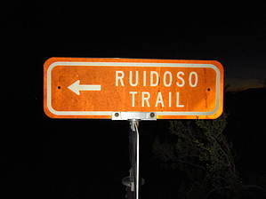
Usery Mountain Park Fun by BEEBEE  The Ruidoso Trail is a light trail. It runs for 1.35 miles from the south Trailhead located on Meridian Road south of McKellips Road to its north end where it intersects with the Spillway trail. The following description is from south to north. The trail itself connects with the Spillway trail and The County line trail. The trail is an excellent way into the center of the trail system in Usery Mountain Park. The route helps avoid the more crowded trailhead located in the main park area and the other popular ones. The trail itself on the southern end is flat and sandy with little to no shade. As you go north from the southern trailhead will first pass the County line trail at its southern end you can pause and enjoy some of the valley and may even catch an air show from the Superstition Airpark model airplane runway. As you move north you will descend into and out of washes l giving you a short shaded break. In this area, you will see more birds, rabbits, lizards, and chipmunks. As you continue north the next trail intersection is the Spillway trail which brings you to the end of Ruidoso. From here you can continue north or go south and explore more of the trails in the Usery Mountain Park Trail system. The trails in Usery are popular with local runners, hikers, mountain bikers, and horseback riders to access the trail system in Usery Mountain Park. The Ruidoso Trail is a light trail. It runs for 1.35 miles from the south Trailhead located on Meridian Road south of McKellips Road to its north end where it intersects with the Spillway trail. The following description is from south to north. The trail itself connects with the Spillway trail and The County line trail. The trail is an excellent way into the center of the trail system in Usery Mountain Park. The route helps avoid the more crowded trailhead located in the main park area and the other popular ones. The trail itself on the southern end is flat and sandy with little to no shade. As you go north from the southern trailhead will first pass the County line trail at its southern end you can pause and enjoy some of the valley and may even catch an air show from the Superstition Airpark model airplane runway. As you move north you will descend into and out of washes l giving you a short shaded break. In this area, you will see more birds, rabbits, lizards, and chipmunks. As you continue north the next trail intersection is the Spillway trail which brings you to the end of Ruidoso. From here you can continue north or go south and explore more of the trails in the Usery Mountain Park Trail system. The trails in Usery are popular with local runners, hikers, mountain bikers, and horseback riders to access the trail system in Usery Mountain Park.Note: This trail gets lots of Mountain Bike and Equestrian activity so the trail can be rutted and also lots of road apples watch where you step
Check out the Official Route and Triplogs. Leave No Trace and +Add a Triplog after your hike to support this local community. One-Way Notice This hike is listed as One-Way. When hiking several trails on a single "hike", log it with a generic name that describes the hike. Then link the trails traveled, check out the example. | ||||||||||||||||||||||||||||||||||||||||||||||||||||||||||||||||||||||||||||||||||


