Route Editor

| Guide | ♦ | 6 Triplogs | 0 Topics |
details | drive | permit | forecast | route |
stats |
photos | triplogs | topics | location |
| 90 | 6 | 0 |
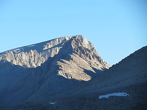
America's southernmost 14er by John10s Mt. Langley (14,032') is one of a dozen peaks of 14,000'+ elevation in California and is the southernmost 14er in the United States. Langley is accessible via a long and strenuous day hike; given the distance, it is a popular backpacking destination, with multiple lakes and prime camping areas along the route. Note that a permit is not required for day use, but overnight stays do require a permit. Langley is considered one of the three easiest California 14ers to summit, along with Mt. Whitney and White Mountain Peak. Although Langley is ~500' lower in elevation than Whitney and the hike has less AEG, Langley is generally considered a more difficult hike because of its higher mileage and a steep section with a poorly-defined trail near the summit.
History Mt. Langley is named after Samuel Piermont Langley, a pioneer in American aviation who served as a director of the Smithsonian and worked as a professor of astronomy at the University of Pittsburgh. In the late 1800s, early climbers confused Mt. Langley with Mt. Whitney, and Langley was subsequently known by several other names before receiving its official name from the Board on Geographic Names in 1943. Hike The hike begins at Cottonwood Lakes Trailhead, which includes a spacious parking lot, bathroom facilities, and a walk-in campground and equestrian camp nearby. Cottonwood Lakes Trail begins at ~10,000' and starts well-maintained and relatively flat, gaining only ~500' over the first three miles. You'll quickly enter the Golden Trout Wilderness, and the trail crosses the South Fork of Cottonwood Creek after ~1.5 miles. Soon after the crossing, an unsigned trail branches off to the left, with deadfall piled to discourage hikers from taking the turn. This is the southern end of South Fork Lakes Trail, which appears to be in the process of being decommissioned as of this writing. Stay on Cottonwood Lakes Trail as it turns north and generally follows Cottonwood Creek, entering the John Muir Wilderness around the three-mile mark. After another creek crossing, the trail curves to the west, and you'll pass a signed intersection indicating Cottonwood Lakes to the right and New Army Pass to the left. A right turn here would eventually lead to Old Army Pass, the alternate route to Mt. Langley mentioned above; stay left to continue toward New Army Pass. The trail quickly crosses Cottonwood Creek for a third time, and you'll pass a sign for South Fork Lakes Trail around the five-mile mark--this is the north end of the previously mentioned trail that is being decommissioned. Continuing toward New Army Pass, Cottonwood Lake #1 and Lake #2 soon appear on the right, and Mt. Langley is visible to the northwest. Beyond the pair of lakes, the trail remains relatively flat and leads through a large boulder field before approaching Long Lake. A short and easy-to-miss sign indicates a left turn in the trail near the south end of the lake, where it continues along the south/west shoreline. In this area, you'll enjoy nice views of New Army Pass to the northwest and Cirque Peak to the southwest. The trail starts to steepen noticeably on the approach to High Lake at ~11,500', surrounded by sheer cliffs on the north and east sides. This is the last water source before the summit, so it's a good spot to filter water before continuing up New Army Pass. From High Lake, the trail steepens again as it climbs a series of switchbacks toward the pass. Along the way, you'll enjoy impressive views of the chain of lakes extending to the southeast: High Lake, Long Lake, and South Fork Lakes. After a climb of ~800', you'll reach New Army Pass at ~12,300' with a metal sign marking the boundary as you enter Sequoia National Park. Langley once again comes into view to the north, and the trail descends ~300' through a series of switchbacks toward Old Army Pass. The trail is a little faint in this area, but it's easy to see where it starts climbing again to the northeast. A metal sign near Old Army Pass marks the boundary of Sequoia National Park, but the pass itself is not labeled. From here, you'll have a nice view to the east overlooking Cottonwood Lake #4 and Lake #5. From Old Army Pass, the trail turns northwest and starts climbing again; this stretch is easy to follow, with a smooth tread as you look directly at Langley ahead. Roughly 1.25 miles beyond the pass is an NPS sign that begins a series of cairns that mark the remainder of the route to the summit and reminds hikers not to knock them down or build new ones. The large cairns seem unnecessary at first--the trail is steep but remains obvious as the tread becomes looser and sandier. As you gain elevation, views of the surrounding lakes continue to improve, including several of the Cottonwood Lakes and South Fork Lakes to the south, plus Soldier Lake and others in Sequoia to the west. Over the final three-quarters of a mile, the route-finding becomes more challenging as the obvious trail splits into multiple tracks that approach a jumble of boulders. Cairns are sparser for the remainder of the route, but as you approach the boulders, a cairn comes into view that marks the NPS-recommended route to a short class 2/3 scramble, with the next cairn visible among the boulders ~10 feet up. Beyond this point, the route becomes steeper, looser, and more difficult to follow, with footprints leading in multiple directions through the sandy terrain--this is the portion of the route where Langley earns its reputation as a more challenging hike than Mt. Whitney. When they're visible, the cairns are helpful, but they're spaced out such that it can be hard to spot the next one in the series. At this point, it's simpler to choose the route with the best footing and use the cairns as general guidance as they come into view. The steepness finally relaxes on the final approach to the summit. The peak includes a benchmark and, as of this writing, several ammo boxes with summit registers. From the summit, you'll have fantastic, hard-earned 360° views. Looking north, Mt. Whitney and more of the Sierra peaks are visible, with Lone Pine down below to the northeast and the Inyo Mountains on the eastern horizon. The beautiful expanse of Sequoia National Park and the seemingly endless series of peaks and lakes extends to the west. When you're ready to head out, you can return via the same route. The good news: other than the 300' climb between Old Army Pass and New Army Pass, the hike out is almost entirely downhill. Check out the Official Route and Triplogs. Note This is a more difficult hike. It would be unwise to attempt this without prior experience hiking. Leave No Trace and +Add a Triplog after your hike to support this local community. | ||||||||||||||||||||||||||||||||||||||||||||||||||||||||||||||||||||||||||||||||||||||||||||||||