 Route Editor

| Guide | ♦ | 10 Triplogs | 1 Topic |
details | drive | no permit | forecast | 🔥 route |
stats |
photos | triplogs | topic | location |
| 149 | 10 | 1 |
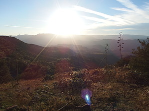
Remote Gem of the Mazzies by jacobemerick  Overview OverviewRemote trail in the Mazatzal Wilderness that ascends Wet Bottom Mesa into a rare, unburnt forest of pines before dropping into Bull Spring Canyon. Western few miles may be used to connect Verde River and Highwater Trail, the rest is seldom traveled. Hike Reaching the western end of this trail is difficult. The simplest approach is to park at the end of FR18 (high-clearance), hike the length of Red Creek (over 4 miles), cross the Verde River at Red Creek Rapids (no bridge), and then follow a short section of Verde River Trail to the trailhead. Other approaches would include hiking longer distances of Verde River or Highwater that could make for excellent multi-day adventures. This trail was not designed for easy access.
The tread remains well-defined beyond the junction, with a few cairns to mark the way eastward, though at 2.3 miles the surrounding terrain changes. Hills began to rise where the mesa was once flat and the trail slides along the north side, sweeping in and out along the numerous drainages. It mostly tracks the contour lines until 3.8 miles, when it cuts south and climbs a shaded drainage with plenty of pines, picking up a few hundred feet before entering a valley of catclaw and mesquite. Getting through this valley without bleeding may be a challenge, though if you're hiking the Mazatzals this is an accepted part of the journey. At 4.3 miles the tread firms up on the far side and climbs steeply along a drainage, gaining 400' as it crosses two rocky washes. Once it crests the saddle on top there is a brief respite, a short bit of following the contour along a semi-defined route, and then at 5.3 miles the trail begins to climb the growing ridgeline to the south, swinging in and out of drainages, choked by plentiful growth, and finding a way forward often means embracing game paths. This section is difficult and will take plenty of time to do safely. At 7.2 miles the grade begins to lessen (though it is still present) and junipers surrounded by fields of grass began to show up, a welcome respite from the thicker vegetation of earlier. The cairns are often large enough to make out in the grass ahead. That ridgeline that the trail had spent so much time dancing along is crested and huge views open up to the south, including Midnight Mesa, Wet Bottom Creek, and even Mazatzal Peak in the far distance. Up here the trail may be difficult to track, yet it barely matters, with so much to see and such open area. The highpoint of the trail is reached and a spur trail to Childer's Seep shows up around 9.1 miles. Unfortunately, this also marks the edge of the Willow Fire, and burn damage will begin to fade in, soon reaching devastating levels. After the spur, there is one short drop into a drainage, one that has some rock tanks just off-trail for a possible source, and then a quick climb on the other side. Once past the drainage, there is a good view down at Bull Spring Canyon at 9.7 miles before a steady drop down to LF Cabin and Bull Spring Trail, where one can continue east to the more traveled parts of the wilderness. Water Sources The only dependable water source is on the far eastern end of the trail, Bull Trap Spring, located next to LF Cabin. Otherwise there are some drainages along the trail that may hold water, or a short venture off-trail will lead to Childer's Seep, Canyon Creek, or Bull Spring. Camping LF Cabin in Bull Spring Canyon would make for an excellent campsite. Also, there are a few spots along the trail, especially on the western half, with fire rings and flat pads for dry campsites. Check out the Official Route and Triplogs. Leave No Trace and +Add a Triplog after your hike to support this local community. One-Way Notice This hike is listed as One-Way. When hiking several trails on a single "hike", log it with a generic name that describes the hike. Then link the trails traveled, check out the example. | ||||||||||||||||||||||||||||||||||||||||||||||||||||||||||||||||||||||||||||||||||||||||||||||||||||||||||||||||||||||||||||||||||||||||||||||||||||||||||||||||||||||||||||||||||||||||||||||||||||||||||||||||||||


