 Route Editor

| Guide | ♦ | 39 Triplogs | 0 Topics |
details | drive | no permit | forecast | 🔥 route |
stats |
photos | triplogs | topics | location |
| 486 | 39 | 0 |
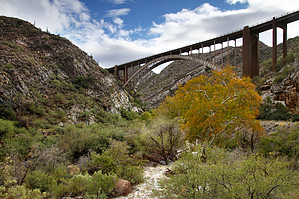
Make a Resolution to see some history by chumley   Overview OverviewThe "Canyon Segment" of the LOST ( Legends of Superior Trail ) follows the old alignment of US Highway 60 from the town of Superior up the lower portion of scenic Queen Creek Canyon through the historic Claypool Tunnel (1919). It's an easy way to spend a couple of hours and may make an excellent secondary activity for those who visit the Boyce Thompson Arboretum and are looking for something else in the area. Details The hike starts at a picnic table adjacent to Queen Creek on AZ 177, just north of the US 60 junction. There is no established trailhead or parking, but there is room for a few cars to park along the dirt road before the gate. Note that the signs on the gate indicate no trespassing, but just to the left side is a LOST trail sign that makes it clear the old road closure signs are not relevant to hikers, mountain bikers, and equestrian users.
After the water tank, the old highway switchbacks up steeply, and you will pass a couple of signs of another old road alignment before approaching the current highway as it enters the current Queen Tunnel (1952). You will reach the highlight of this trip two miles from the start, the historic Claypool Tunnel, constructed when this road was built in 1919-1922. The tunnel is the official end of the trail, and many will turn around here, but you can continue up another quarter mile until you reach the highway at the east end of the currently used tunnel. Most will turn around and head back downhill, and the mileage and distance listed here reflect that likelihood, but there is the option to make this a one-way hike if you set up a shuttle at the small pull-out along US 60 just east of the tunnel. Gate Policy: If a gate is closed upon arrival, leave it closed after you go through. If it is open, leave it open. Leaving a closed gate open may put cattle in danger. Closing an open gate may cut them off from water. Please be respectful, leave gates as found. The exception is signage on the gate directing you otherwise.
Check out the Official Route and Triplogs. Leave No Trace and +Add a Triplog after your hike to support this local community. One-Way Notice This hike is listed as One-Way. When hiking several trails on a single "hike", log it with a generic name that describes the hike. Then link the trails traveled, check out the example. | |||||||||||||||||||||||||||||||||||||||||||||||||||||||||||||||||||||||||||||||||||||||||||


