Route Editor

| Guide | ♦ | 9 Triplogs | 0 Topics |
details | drive | no permit | forecast | route |
stats |
photos | triplogs | topics | location |
| 85 | 9 | 0 |
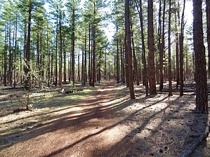
don't get lost by TrekSafari   I saw two coyotes crossing my path; I was far enough away to pay me no attention. There were a lot of prints from deer since the last rain. Two bikes and several hikers also left their footprints. Buena Vista Trail generally follows old logging roads. Consequently, the trail is typically about five wide. There are a lot of roads, trails, and paths crossing the trail. I walked the loop clockwise. I saw two coyotes crossing my path; I was far enough away to pay me no attention. There were a lot of prints from deer since the last rain. Two bikes and several hikers also left their footprints. Buena Vista Trail generally follows old logging roads. Consequently, the trail is typically about five wide. There are a lot of roads, trails, and paths crossing the trail. I walked the loop clockwise.Notice that the solid Blue signs have a Yellow dot at the shortcut. The main trail proceeds uphill on a narrow path almost adjacent to the Shortcut sign; look to your left.
Apparently, there is still active logging in the area. Many trees were painted with a blue stripe designating they were to be cut. Apache - Sitgreaves FS Details The Buena Vista Trail is a moderately difficult, 9 mile loop trail that follows portions of old logging roads through a hilly landscape covered with oak, manzanita, and pine trees. With an approximate elevation gain of 200 feet, the trail gives some impressive views of the Colorado Plateau to the north, as well as spectacular views of Mt. Baldy to the east. The route includes nine uphill sections and sections of loose rocks, which can be challenging on a mountain bicycle. Be sure to keep your eyes open for trail markers to help keep you on the trail as the trail utilizes and crosses many old roads and trails. Also keep a lookout for animal tracks in the sandy soil along the trail. Some animals to look out for are elk, deer, bear, scorpions and beetles. Check out the Official Route and Triplogs. Leave No Trace and +Add a Triplog after your hike to support this local community. | ||||||||||||||||||||||||||||||||||||||||||||||||||||||||||||||||||||||||