 Route Editor

| Guide | ♦ | 14 Triplogs | 0 Topics |
details | drive | permit | forecast | map |
stats |
photos | triplogs | topics | location |
| 79 | 14 | 0 |
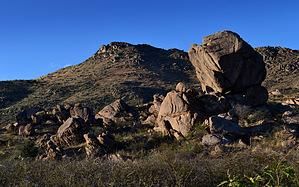
  Overview OverviewHike may be started from either Gillespie Well or the P Ranch. This description starts from Gillespie Well and follows an unmarked/unnamed dirt road east through many fascinating boulder formations, then rounds Gillespie Mountain heading north where the road ends and wash hiking takes you down to the P Ranch. Check out the Triplogs. Leave No Trace and +Add a Triplog after your hike to support this local community. One-Way Notice This hike is listed as One-Way. When hiking several trails on a single "hike", log it with a generic name that describes the hike. Then link the trails traveled, check out the example. | |||||||||||||||||||||||||||||||||||||||||||||||||||||||||||||||||||||||||


