 Route Editor

| Guide | ♦ | 36 Triplogs | 0 Topics |
details | drive | no permit | forecast | route |
stats |
photos | triplogs | topics | location |
| 368 | 36 | 0 |
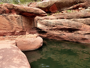
  Overview OverviewThis guide represents the full trail. The more popular option is to "The Crack" at Bell Crossing and back. Bell Trail #13 is the only developed route into Wet Beaver Creek Canyon and the Wilderness Area it shelters. It is a very popular trail with hikers and anglers who come to enjoy the solitude and other rewards offered by a clear, cool stream flowing through a scenic desert canyon.
For the most part, the trail follows a route along a bench well above the streambed. However, several side trails lead down to the waterside and possibly indicate suitable swimming holes or popular fishing spots. If you take advantage of these well-used detours, you'll find several places along the stream where deepwater holes alternate with bubbling riffles to invite you to take a dip or wet your line. At one point, the trail leaves the canyon bottom to wind high along an escarpment of red sandstone and offers scenic views of the riparian area, the canyon, and the surrounding mountains and valleys. Most people who come to this trail hike only the first 3.3 miles to Bell Crossing, taking advantage of any one of several access paths that branch off the main trail and lead down to the stream. After crossing the Wet Beaver Creek, the Bell Trail climbs the canyon's south wall to a high, grassy plateau where it winds through pinyon-juniper stands and open grasslands, offering views that stretch to the Sedona Red Rocks Country and the San Francisco Peaks. Eleven miles from the trailhead at Beaver Creek, Bell Trail ends at Forest Road 214. Check out the Official Route and Triplogs. Leave No Trace and +Add a Triplog after your hike to support this local community. One-Way Notice This hike is listed as One-Way. When hiking several trails on a single "hike", log it with a generic name that describes the hike. Then link the trails traveled, check out the example. | ||||||||||||||||||||||||||||||||||||||||||||||||||||||||||||||||||||||||||||||||||||||||||||||||||||||||||||||||||||||||||||||||||||||||||||||||||||||||||||||||||||||||||||||||||||||||||


